El Niño was officially declared in June 2026, raising the prospect of widespread impacts across Southeast Asia, from extreme heat and water shortages to higher energy demand and agricultural stress.
The World Meteorological Organization has warned countries to “prepare for it to be severe”, while several global forecast models suggest the event could rank among the strongest on record.
What is El Niño?
El Niño is one of three phases of the El Niño-Southern Oscillation (ENSO) – a global ocean and atmosphere phenomenon originating in the tropical Pacific. El Niño occurs when sea surface temperatures in the tropical Pacific become warmer than average and trade winds blowing across the tropical Pacific weaken or reverse.
These changes cause cloud and rainfall to become suppressed in the western Pacific and enhanced over the central and eastern Pacific. The images below show how El Niño changes rainfall and temperatures patterns across the world.
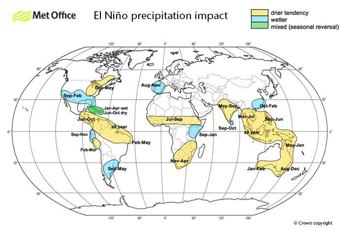
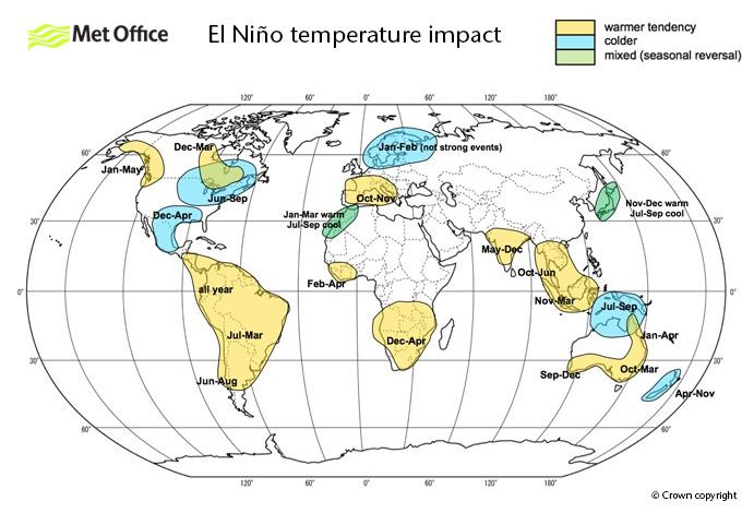
Images: El Niño precipitation (top) and temperature (bottom) impact across the globe, with yellow showing drier and warmer conditions and blue showing wetter and colder. Source: UK Met Office.
This El Niño could be one for the record books
Current forecasts indicate that this El Niño will continue to strengthen through the second half of 2026 and should persist into early 2027. This event is expected to become strong or very strong, with the Bureau pointing out that “around half of the models indicate this event could peak at levels among the highest observed since 1950.”
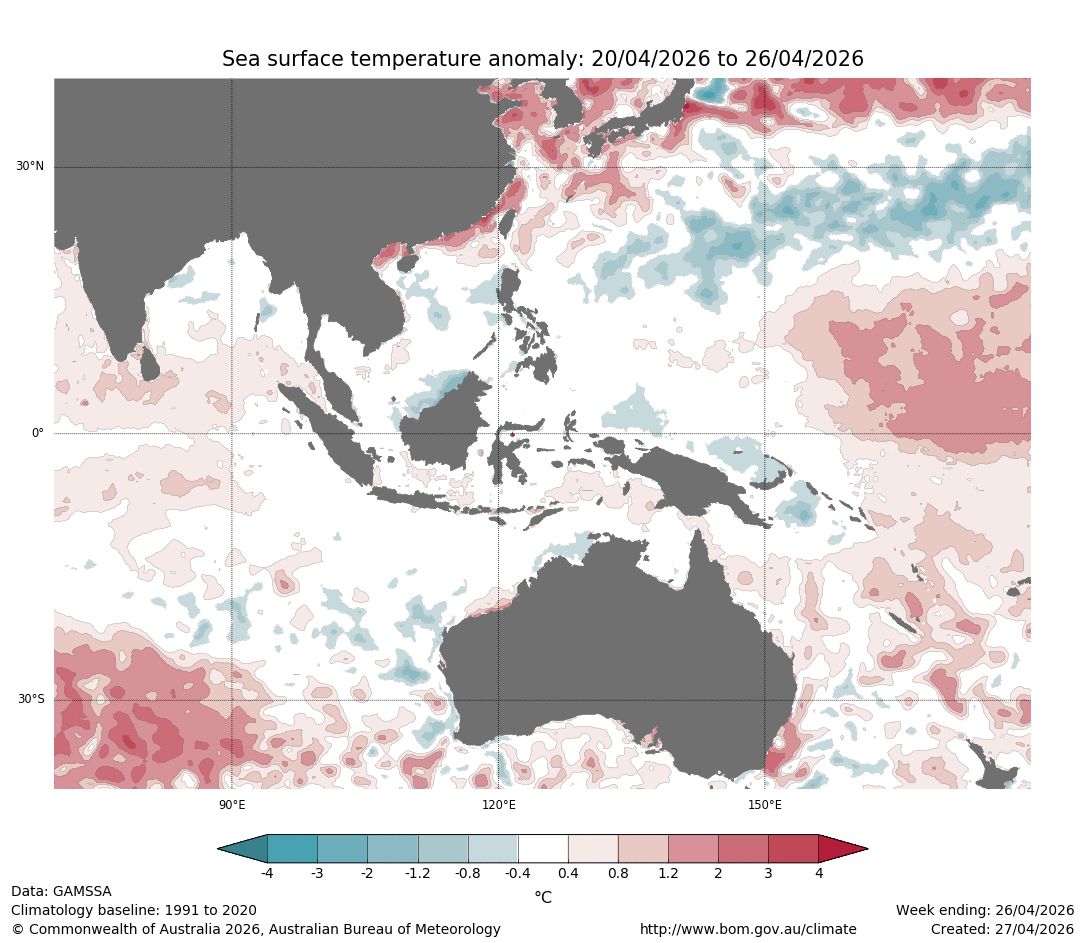
One of the key metrics used to measure El Niño is the relative Niño3.4 index – a measure of sea surface temperature anomalies on the central tropical Pacific Ocean. In Australia, El Niño occurs when the relative Niño3.4 index is above +0.8°C for a prolonged period.
Images: NOAA Daily Sea Surface Temperature (SST) anomalies between May 25 and June 23, 2026. Source NOAA Coral Reef Watch.
According to data on the Bureau of Meteorology’s website, the highest monthly Niño 3.4 value in records dating back to 1900 was +2.65°C in November 1902. The Bureau’s ACCESS-S model currently forecasts the relative Niño3.4 index to reach +3.3°C in November this year, which would obliterate the old record by more than 0.6°C.
What does this El Niño mean for southeast Asia?
Broadly, temperatures across southeast Asia are forecast to be warmer than average particularly at the end of the dry season. Extreme heat events are more likely which is very relevant to industries that are managing heat stress in the workplace, equipment and perishable goods.
The rainfall picture shifts country to country and month to month, shaped by local weather patterns that can alter any forecast – the following reflects average conditions across the entire season.
Malaysia and Singapore
During July to September these countries typically are significantly drier-than-normal during El Niño years, however later in 2026 the signal reverses with wetter tendencies likely impacting the region.
Hong Kong and southern China
Typically, the regions see wetter-than-normal conditions in July and August which increases flood and landslide risk, with implications for logistics, construction, infrastructure operations and marine activity.
Philippines and Thailand
Generally, the signal is drier with reduced monsoon reliability, stressing water-dependent agriculture and hydropower. The drier tendency also increases fire risk, though there is higher variation in these countries, which can be wetter in some years.
Pakistan and Nepal
These countries face widespread drier-than-normal conditions under the current outlook, however slow-moving, localised rainfall events are possible and given dry and hard ground conditions, can produce disproportionate flash flooding when they do occur. Pakistan’s agricultural sector and Nepal’s hydropower industry face elevated risk from reduced monsoon inflows, while remaining alert to episodic high-rainfall events.
India
El Niño events reliably suppress monsoon rainfall across much of the country, particularly over central and peninsular India. In fact, the monsoon has collapsed with the IMD reporting a rainfall deficit of 64% between June 4 and June 15, 2026, consequently. Central Indian mining operations could see reduced flood-related disruptions during the wet season but can amplify heat stress, dust.
The ECMWF seasonal forecast maps below illustrate the forecast precipitation anomaly for July and August – when the drier signal across South and Southeast Asia is at its strongest -and November, when the pattern begins to reverse for parts of the region.
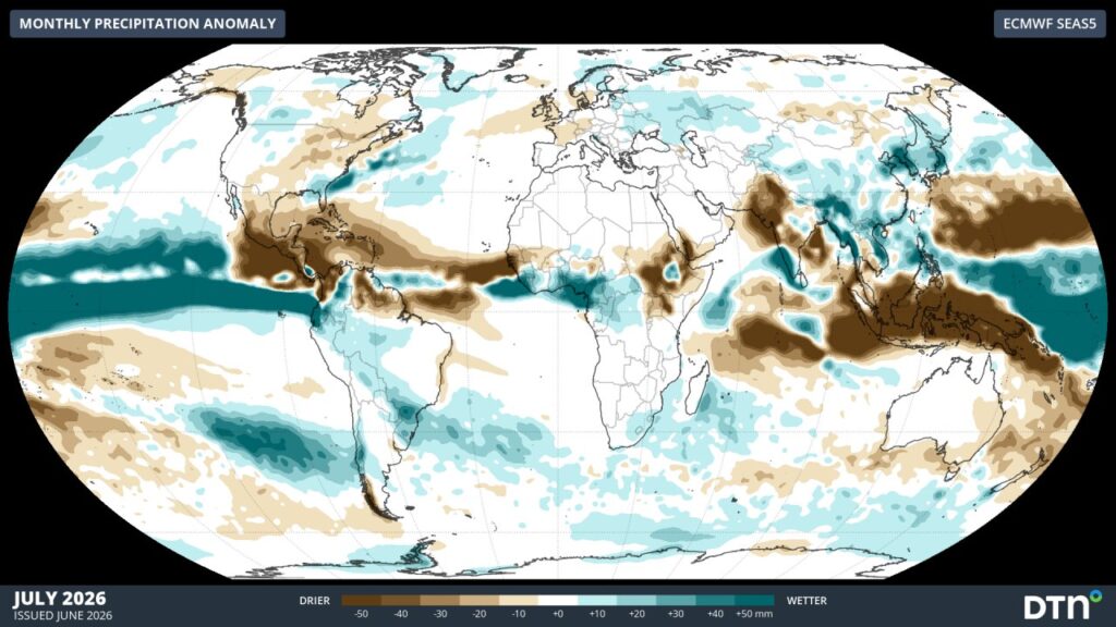
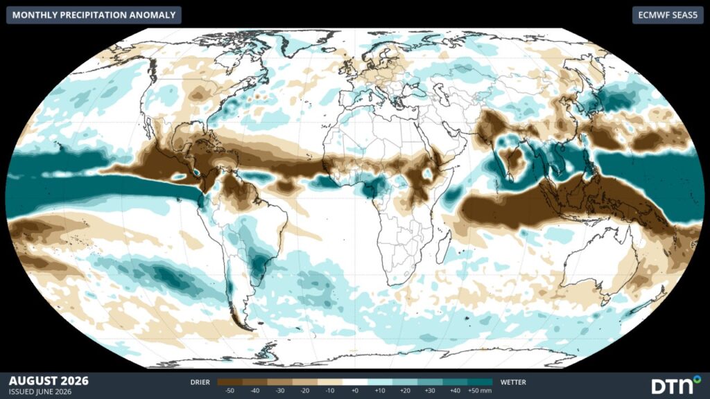
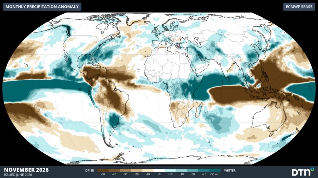
Images: ECMWF SEAS5 monthly precipitation anomalies for July, August and November (top to bottom)
Australia: Drier, Hotter, and longer fire season
The maps above show that El Niño should reduce rainfall across eastern and southern Australia in the second half of the year. El Niño also warms the continent, increases fire weather risk, reduces alpine snowfall delays the northern monsoon and reduces cyclone numbers. It typically causes the most significant impacts during spring and early summer.
For Australian businesses, the risk profile is well-understood but demands active management:
- Mining: Dry conditions can aid productivity but elevate fire risk, heat stress on workers and equipment, and dust events all require careful monitoring.
- Energy: Above-average temperatures drive demand peaks in summer. Stronger wind generation can occur during spring, and dry conditions can elevate fire risk near transmission infrastructure.
- Agriculture: Reduced winter and spring rainfall compresses the growing window for winter cropping regions.
- Marine and Ports: El Niño can increase wind and swell Australia’s coastline during spring.
Along with El Niño, a positive IOD could develop later in the season, driving wetter-than-normal conditions across India and southern China. Across much of Southeast Asia and Australia, however, the combination of El Niño and a positive IOD could have a compounding drying effect. DTN APAC will continue tracking these interactions and advising our clients.
How DTN APAC Can Help
As El Niño intensifies through winter and spring, operational decisions depend not just on understanding the broad climate signal — but on knowing what it means for your specific site, sector, and supply chain.
DTN APAC provides layered weather intelligence connecting large-scale climate drivers like El Niño to real-world business outcomes:
- Seasonal rainfall and temperature outlooks — connecting El Niño’s global signal to regional and site-level impacts across Asia, India, and Australia
- Sub-seasonal forecasting (2–6 weeks) — identifying emerging high-impact weather windows before they become operational disruptions
- Industry-specific solutions — tailored forecasting for mining, energy, marine, aviation, agriculture, insurance, and transport across the APAC region
- Monitoring and alerting — real-time tracking of heat, fire weather, drought, tropical activity, and extreme rainfall events
- Expert consultation — direct access to DTN’s meteorology team for scenario planning and risk assessment
Whether you are managing operations in the Pilbara, running mine sites in Southeast Asia, or planning around India’s monsoon season, the El Niño signal is too significant to monitor passively.
Get in touch with the DTN APAC team to understand what El Niño means for your business: Contact Us
Thumbnail: Bureau of Meteorology SST anomaly maps