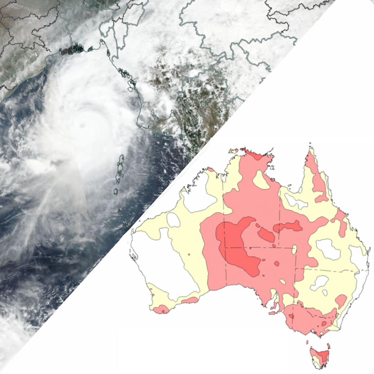
Tropical Cyclone Mocha, which devastated Myanmar and Bangladesh earlier this month, may have set off a chain-reaction in the Indian Ocean Dipole that will lead to a hot, dry spring in Australia this year.
Tropical Cyclone Mocha was a powerful system that formed in the northeastern Indian Ocean, over the Bay of Bengal, on May 9. This powerful system intensified into the equivalent of a category 5 tropical cyclone with 1-minute sustained winds of 280km/h, before making landfall over Myanmar on May 14. This makes Mocha the equal-strongest tropical cyclone to form in the northern Indian Ocean on record, tied with Cyclone Fani in 2019.
BREAKING: Cyclone #Mocha is making landfall in #Myanmar (near #Sittwe) with 1-min winds of 135 kts (250 km/h) in the US JTWC scale.
It ties with Cyclone Giri (2010) as the strongest landfalling tropical cyclone in Myanmar in recorded history, in terms of 1-min sustained winds. pic.twitter.com/aphjhKmHpU
— Matthew Cuyugan (@MatthewCuyugan) May 14, 2023
#MochaCyclone It is currently close to the highest tide time in Sittwe, be careful of storm surge! pic.twitter.com/pZgylNjSTw
— Jim yang (@yangyubin1998) May 14, 2023
In addition to the destruction and loss of life caused by this devastating cyclone, Mocha appears to have changed the air pressure balance across the Indian Ocean, which could lead to a positive Indian Ocean Dipole (IOD) developing this year.
The IOD is a similar climate driver to El Niño and La Niña in the Pacific Ocean. It is based on the interaction of ocean temperatures and the overlying atmosphere of the tropical Indian Ocean, which leads to changes in rainfall and temperatures over Australia.
The IOD has its strongest effect on the weather during winter and spring, but unlike El Niño and La Niña, it becomes irrelevant during summer once the north Australian monsoon first arrives. The IOD can be in three states: positive, negative and neutral.
During a positive IOD, warm waters are pushed towards Africa and away from Indonesia and Australia. Much like an El Nino, the atmosphere responds by increasing convection and rainfall near Africa.
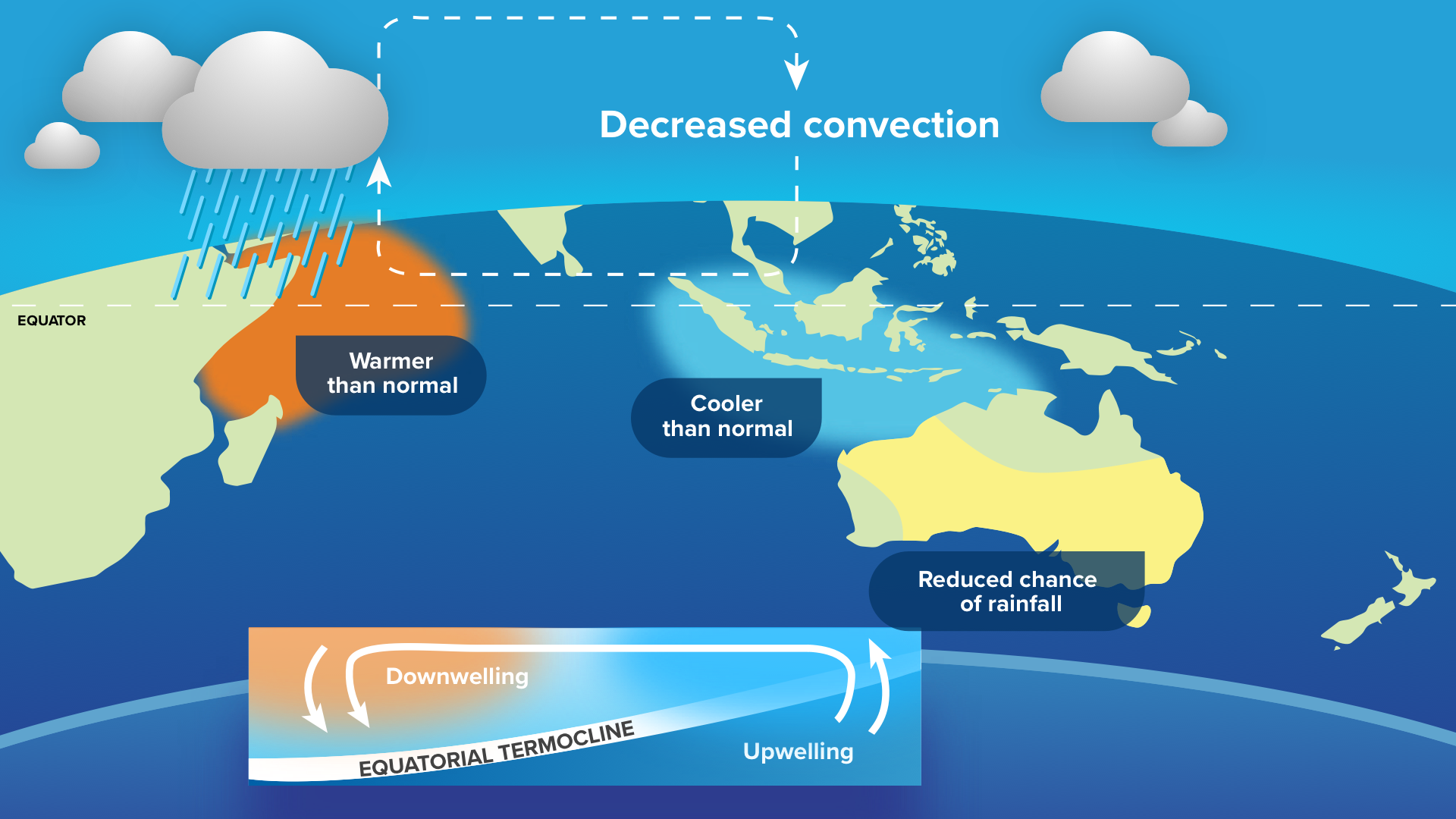
Image: Diagram of a positive IOD
Over Australia, rainfall and cloud formation is suppressed during positive IOD events, leading to drier but also hotter conditions over the continent. Rainfall tends to be most reduced in South Australia and the Murray-Darling basin, due to the lack of northwest cloudbands.
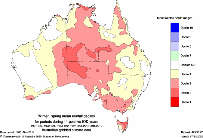
Image: Typical winter and spring rainfall over Australia during positive IODs. Source BoM
Research from Francis et al. 2007 shows that strong tropical cyclones forming in the Bay of Bengal during April or May often leads to a positive IOD later that year. They found that all eight positive IODs between 1958 and 1999 were preceded by a severe tropical cyclone over the Bay of Bengal.
These cyclones created positive IOD events by the following sequence:
- The pressure gradient over the region causes southeasterly winds to increase off the Indonesian coast
- Moisture content drops and skies become clearer near Indonesia
- Easterly winds start to develop along the equator
- Warm waters are pushed towards Africa
- Convection increases near Africa, while the atmosphere starts to suppress convection near Indonesia
- Colder waters start to upwell near Indonesia
- The circulation repeats steps 2-6, amplifying over time into a fully developed positive IOD
It appears that Tropical Cyclone Mocha has already initiated the above sequence, increasing the likelihood that we could see a positive IOD in 2023.
So far, step 1 has been clear in the last few weeks, with high pressure to the south directing persistent southeasterly winds along the Indonesian Coast. Conditions developing this week suggest that skies are also becoming clearer to the west of Indonesia, possibly signalling that step 2 has started.
It is worth noting that not all April/May tropical cyclones in the Bay of Bengal have triggered positive IODs, such as in 1990, but there are good indications that they can trigger these events. However, all international models are currently signalling a positive IOD to be active during this winter and spring.
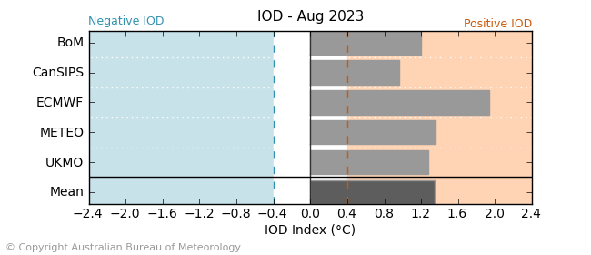
Image: International forecasts of the IOD. All five are showing positive IOD thresholds to be met during this year.
Weatherzone will keep an eye on the potential development of the IOD over the coming weeks and months.
DTN APAC can provide tailored climate briefings to your business to alert you of the most likely weather conditions and hazards to look out for during the upcoming season. Now is a good time to get a good look at the forecast for winter, spring and beyond. To find out more or to book a presentation, please email apac.sales@dtn.com.


