
Australia’s mean maximum temperature in 2023 was 1.34ºC warmer than the 30-year period ending in 1990, making it the country’s 5th warmest year on record.
The combined warming effects of El Niño, a positive Indian Ocean Dipole (IOD) and climate change helped make 2023 one of Australia’s top 10 warmest years ever recorded.
Every state and territory registered an annual mean temperature in 2023 that was warmer than the 1961-1990 average, with NSW/ACT, SA, Tas and WA all experiencing one of their top seven warmest years on record.
The national mean temperature (combined minimums and maximums) in 2023 was 0.98ºC above the 1961-1990 average, which was Australia’s 8th warmest year in 114 years of records. The county’s maximum temperature anomaly of +1.34ºC was the 5th highest on record, while the national mean temperature anomaly of +0.61ºC was the 17th warmest on record.
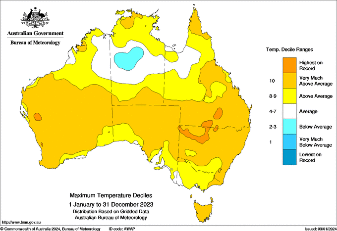
Image: Observed maximum temperature deciles during 2023. Source: Bureau of Meteorology
Rainfall was close to average when looking at the year for Australia as a whole. However, there were some notably wet and dry periods and contrasts across the country.
Heavy rain caused flooding across the nation’s interior and north early in the year under the influence of La Niña. There was also heavy rain in parts of eastern and southeastern Australia towards the end of the year, driven partially by Tropical Cyclone Jasper.
These two wet periods bookended an exceptionally dry spell in the middle of 2023, with August to October ranging as the country’s driest three-month period on record. While the influence of El Niño and a positive IOD waned towards the end of the year, these climate drivers had a noticeable influence from later winter to early spring.
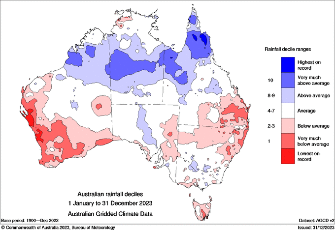
Image: Rainfall deciles during 2023. Source: Bureau of Meteorology
Australia’s warm year occurred amid a backdrop of record-breaking global warmth in both the oceans and atmosphere. While the final numbers are still being compiled, 2023 is likely to go down as Earth’s warmest year on record based on global air and ocean temperatures.
Our long-range forecasts enable you to prepare for the seasons ahead – whether it’s tropical cyclone risk, La Niña’s above average rainfall or the bushfire seasons of El Niño. For more information, please contact us at apac.sales@dtn.com.


