Prosper in a dynamic world
Search

Geraldton’s hottest September day in more than a century of records

It was Geraldton’s hottest September day in more than a century. Temperature records are being broken in WA today as a searing air mass spreads across the state’s north and west.

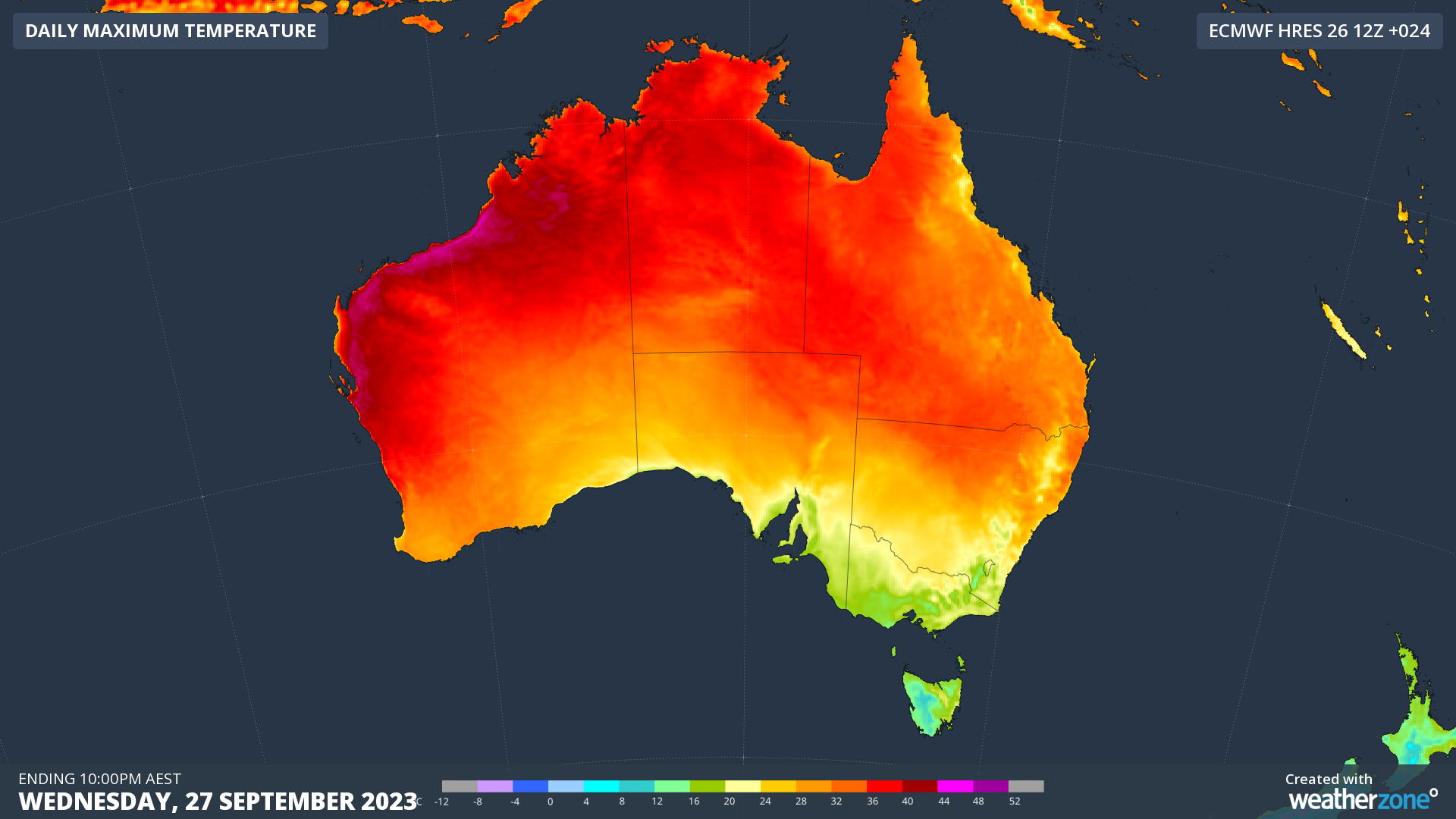
A high pressure system centred over the Great Australian Bight is causing a pool of hot air to intensify over northwestern Australia, with temperatures soaring 15ºC above average in some areas today.
Geraldton's hottest September day. century of records

Image: Modelled maximum temperatures on Wednesday, September 27, according to the ECMWF-HRES model.

As of midday on Wednesday, September 27, temperatures in the state’s north had already reached as high as 41.4ºC at Mardie.

Geraldton’s hottest September had a running maximum of 38.0ºC by midday which was its highest September temperature on record, easily beating the old record of 36.1ºC from 2010. This is an impressive record, with data at Geraldton dating back to 1907.

Perth had only reached 30.3ºC by midday, although the city is forecast to reach around 34ºC in the afternoon. This could challenge the city’s September record of 34.2ºC from 2014.

Other records may fall in WA during the afternoon. This story will be updated with more information later in the day. For more information on Weatherzone’s extreme temperature forecasts, please contact us at apac.sales@dtn.com.

Latest news

Satisfy your weather obsession with these news headlines from around the nation, and the world.

East Coast Low to bring flooding rain, gales, huge waves to eastern NSW

Warnings for strong to gale force winds, hazardous surf and flooding are in place across eastern NSW and southeast Queensland as an East Coast Low develops. A deepening coastal trough over southeast Queensland and northeast NSW has already brought widespread falls of 30 to 70mm over Sunday afternoon and Monday morning. Dunwich Airport, on North […]

East Coast Low brewing for coastal NSW next week

Heavy rain, intense winds and large surf could impact eastern NSW next week as a significant low pressure system develops off the coast, with potential for an East Coast Low. East Coast Lows (ECL) are a type of low pressure systems that rapidly form and stay within close proximity to the east coast of Australia […]

Possible negative IOD could impact mining industry

Signals of a negative Indian Ocean Dipole (IOD) developing in the coming months could bring increased risk of heavy rainfall, severe thunderstorms and tropical cyclones for the mining sector. Indian Ocean Dipole (IOD) The IOD is a measure of the difference in sea surface temperatures across the equatorial Indian Ocean. A negative IOD occurs when […]

Polar blast brings high energy demand to southeast Australia

A cold front sweeping over southeastern Australia is bringing an icy polar blast and chilly nights. The animation below shows the forecast temperatures at 850 hPa (approximately 1,500 metres up) easily dropping between –2°C to -4°C above the capital cities, which translates to near sea-level surface temperatures in the low-teens. Video: Forecast 850 hPa temperatures over […]