
Winter is usually the peak season for East Coast Lows in Australia, but this year has been eerily quiet in the Tasman Sea. So, where have all the ECLs gone?
East Coast Lows (ECLs) are intense low pressure systems that cause severe weather along Australia’s east coast, mostly between southeast Qld and eastern Vic. They are one of the most dangerous maritime weather systems in eastern Australia.
All East Coast Lows cause severe weather, and the most common impacts include one or more of the following:
- Gale to storm force winds near the coast, with tornados also possible
- Heavy, widespread rain that can cause flash and/or major riverine flooding
- Very rough seas and prolonged large waves and heavy swells over coastal and ocean waters
- Coastal erosion and inundation
Australia typically sees a few East Coast Lows each year, on average, while the strongest systems that cause the most severe impacts occur once every few years.
One of the most recent high-impact East Coast Lows occurred in June 2016. This powerful low and an associated coastal trough caused severe flooding and coastal erosion in eastern NSW. One of the standout features of this event was a long period east to northeasterly swell that caused significant coastal erosion at north-facing beaches that are typically protected from large waves.
 Image: Satellite image of cloud feeding into an East Coast Low and assocaited low pressure trough on June 5, 2016. Source: NASA Worldview
Another well-known month for East Coast Lows was June 2007, which saw five separate East Coast Lows during the month, one of which caused the Pasha Bulker to run aground near Newcastle. This system produced wind gusts up to 135 km/h at Norah Head and dumped close to 300 mm of rain in 24 hours at Mangrove Mountain.
Image: The Pasha Bulker sits beached on Nobby’s Beach, Newcastle in June 2007. Source: AAP/ Dean Lewins
It’s no surprise that these two infamous East Coast Lows occurred during June. While these damaging weather systems can form at any time of year, they are most likely during winter and have a peak frequency in June.
This season, however, we have seen no East Coast Lows forming during the winter months. So, what has made this winter so quiet in the Tasman Sea?
Recent research has found that two key ingredients for the development of intense East Coast Lows are the presence of an upper-level low above southeastern Australia and a surface low pressure system more directly over the east coast. When this pattern is in place, the upper-level low helps the surface low gain strength and linger near the coast. While the surface low causes the direct impacts, it is the upper-level low that provides the energy.
The charts below show the upper-level weather patterns from June 2007 and June 2016. Both months saw upper-level lows passing over southeastern Australia, with an associated increase in surface-based low pressure near the east coast.
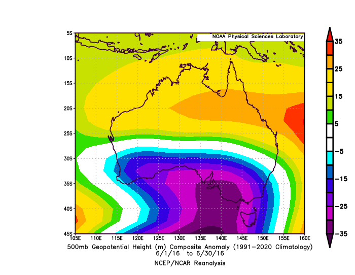
Images: 500 hPa geopotential height anomalies for June 2007 (top) and June 2016 (bottom). Source: NOAA
By contrast, this winter has been dominated by blocking high pressure systems over Australia’s east coast, which has forced upper-level low pressure system to be located too far west to promote East Coast Low development. As a result, we have seen no East Coast Lows forming near Australia so far this season.
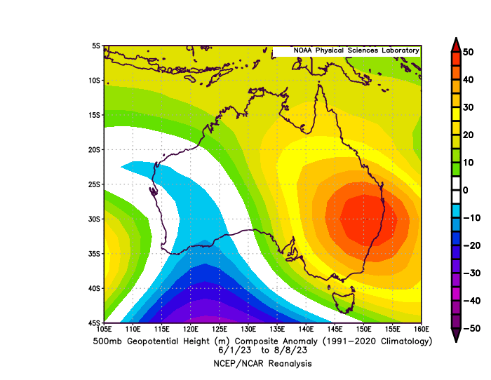
Image: 500 hPa geopotential height anomalies for the 2023 winter to date (June 1 to August 8). Source: NOAA
Another factor that influences the formation of East Coast Lows are sea surface temperatures in the Tasman Sea. In general, warmer ocean temperatures promote the development of low pressure systems near the NSW coast.
The maps below show that most of the Tasman Sea was warmer than average in the middle of June 2007 and June 2016, which helped cause the high-impact East Coast Lows in those months. In mid-June this year, however, there were more areas of cooler-than-average water at the surface of the Tasman Sea.
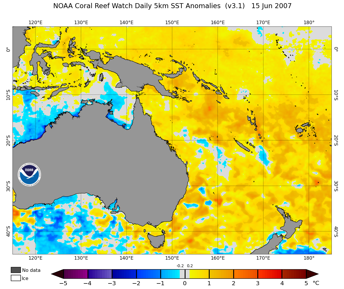
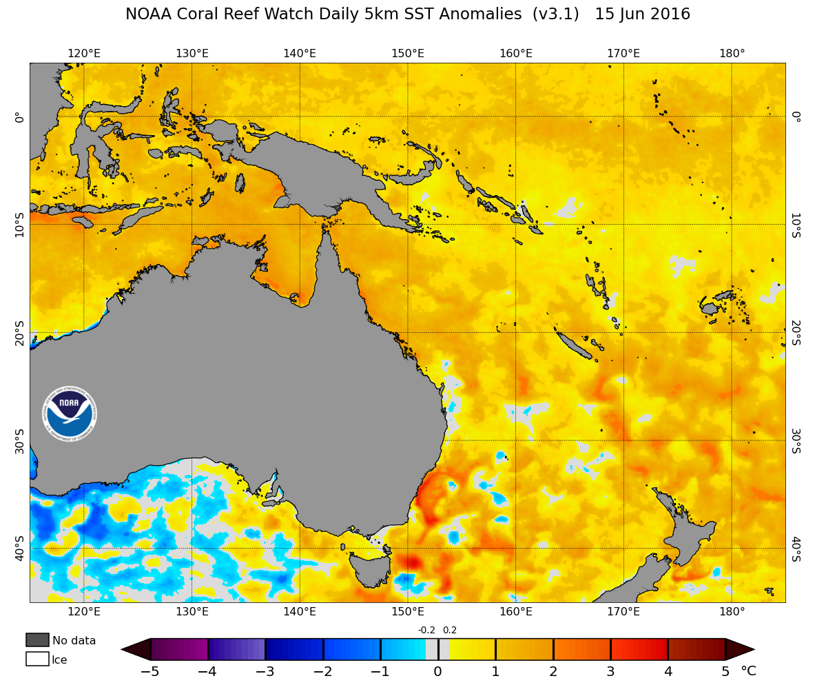
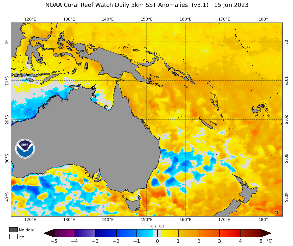
Images: Sea surface temperature anomalies in the middle of June 2007 (top), 2016 (middle) and 2023 (bottom). Source: NOAA
A combination of weather patterns and sea surface temperatures have prevented East Coast Lows from forming this winter.
Looking ahead, there are no strong signs that this pattern will change substantially in the next few weeks, which may continue to limit the development of East Coast Lows as we head into spring. However, individual East Coast Lows are still possible, so be sure to stay up to date with the latest forecasts and warnings if you line in eastern Australia.
DTN APAC offers a comprehensive suite of services, refined through years of collaboration with the marine, ports, insurance and offshore industries, to optimise the safety and efficiency of your operations.
We work with you to understand your intrinsic operational challenges and customise high-precision forecasting, metocean, insurance and aviation services to your exact location and operational scope. For more information, please contact us at apac.sales@dtn.com




