
Another prolonged spell of cold, wet and windy weather will spread over a large area of southern, central and eastern Australia next week.
The final days of May and first few days of winter saw a powerful burst of cold and damaging winds surging across southeastern Australia.
This blustery cold snap caused daytime temperatures to stay 4 to 7ºC below average over large areas of NSW, TAS, SA and VIC, driving up energy demand and damaging energy network infrastructure at the same time.
Now, another mass of frigid air has its sights on Australia and some areas could see even lower temperatures, and more damaging winds, over the coming week.
The first in a series of cold fronts will move over SA on Friday before weakening over TAS and VIC on Friday night into Saturday morning. This will be a relatively weak system without any significant impacts.
Another stronger front and associated low pressure system will then move over southeastern Australia on the weekend, causing a burst of cold, wet and windy weather on the weekend and into early next week.
The strongest winds from this system will occur between Saturday night and Monday night, with damaging gusts possible in parts of SA, TAS, VIC, the ACT, NSW and southern QLD. This wind poses a risk to key electricity infrastructure across the National Electricity Market and other wind-prone industries. While this period of increased winds will increase wind power generation, it may be too strong at times and cause cut-offs at wind farms. Wind should ease on Tuesday into Wednesday, although another frontal system could cause winds to restrengthen from Thursday and possibly linger into the weekend.


Image: Forecast wind gust speed and direction at 1pm AEST on Sunday, June 5 (top) and Monday, June 6 (bottom), according to the ECMWF-HRES model.
This flurry of strong cold fronts will also drag very cold air from the fringes of Antarctica over a board area of Australia during the coming week.
Temperatures will start to drop with the passage of the first front this weekend, before cold air continues to spread across southern, central and eastern Australia throughout most of next week. Some of this cold air could even reach the tropics towards the end of next week.
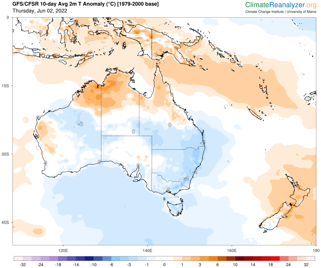
The map below shows the predicted temperature anomaly over the next 10 days combined, with much of Australia likely to be cooler-than-average for this time of year.

Image: Modelled 2m air temperature anomaly during the 10 days starting on June 2, 2022. Source: ClimateReanalyzer.org
Maximum temperatures are expected to be about 1 to 4 degrees below average in Adelaide, Melbourne, Hobart, Sydney, Brisbane and Canberra on most days next week. This prolonged period of cooler-than-average weather is likely to increase energy demand across the National Electricity Market, even more than usual for the first fortnight of winter.
Based on current forecasts, Sydney could stay under 19ºC during the first fortnight of winter. This hasn’t happened since 2000.
This impending cold weather will also bring widespread showers across southeastern Australia, along with snow in elevated areas of TAS, VIC, NSW and the ACT.
Snow will fall in the alps from Friday through the weekend, before flakes start to become more widespread and reach lower levels outside the Alps from Monday until at least Wednesday. Snow could settle in central and northern NSW in the middle of next week.
The mainland alps cold see more than 50cm of snow between this Friday and the middle of next week, with higher ski resorts likely to see the most snow.
Severe weather warnings are likely to be issued in the coming days, so be sure to check the latest warnings and forecasts in your area.
Weatherzone’s Energy services are designed to put the power back in your hands. Our principle value proposition to the energy industry is the timely delivery of highly accurate weather information, to allow intelligent and effective decision making, reducing weather risk and maximizing profit. Weatherzone leads the energy industry with a wide range of products and systems that allow better visibility on forecast generation (such as wind and solar) as well as demand.
No matter how volatile the market is, Weatherzone’s energy services are designed to give you the tools to understand risk and make quick and correct decisions. For more information, please contact us at apac.sales@dtn.com.




