Prosper in a dynamic world
Search

Who had Australia’s coldest start to winter?


Today is the first day of winter in the Southern Hemisphere and for much of Australia, the season has arrived with a timely polar blast. So, who endured the lowest temperatures in Australia on the first morning of winter?

The map below shows the lowest temperatures recorded at official weather stations on the morning of Wednesday, June 1, 2022.

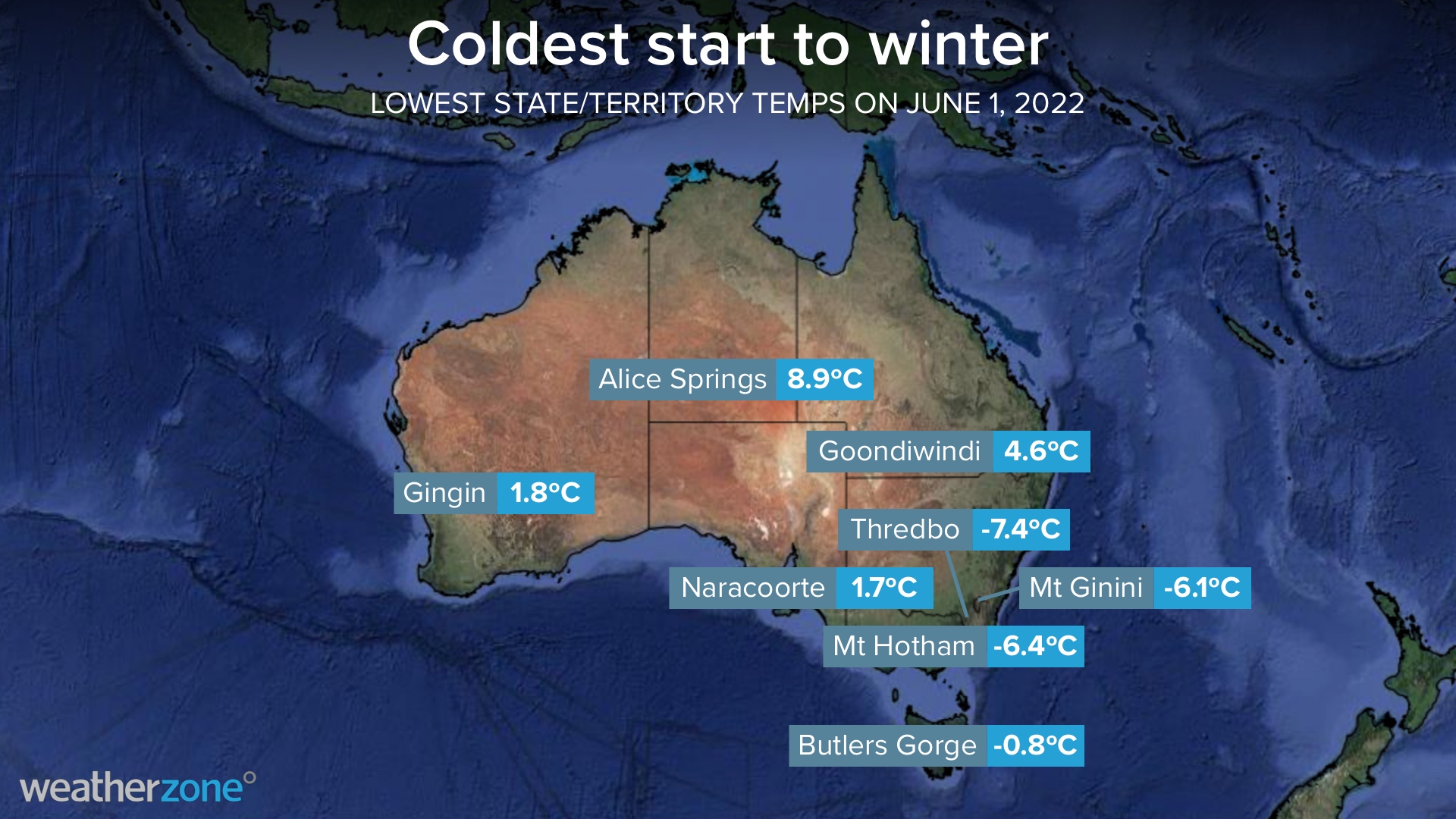
The lowest temperature in Australia was recorded at  Thredbo Top Station in the NSW Snowy Mountains, where the temperature reached -7.4C shortly after 6am. This isn’t a surprise, given this is Australia’s highest weather station (1957m) and the Alps have seen around half a metre of snow in the past 48 hours.

Wind chill was also making temperatures feel fittingly freezing over large areas of southern and eastern Australia on the first morning of winter.

The temperature in Sydney felt like 1ºC at 8:30am thanks to fresh to strong westerly winds blowing over the city. In Canberra, the wind chill made it feel like -5ºC around 6:30am. For more information on Weatherzone’s 14 day temperature forecasts, please contact us at apac.sales@dtn.com.

Latest news

Satisfy your weather obsession with these news headlines from around the nation, and the world.

El Niño Is Here: What a Potential Record Event Means for Southeast Asia and Australia

  El Niño was officially declared in June 2026, raising the prospect of widespread impacts across Southeast Asia, from extreme heat and water shortages to higher energy demand and agricultural stress.   The World Meteorological Organization has warned countries to “prepare for it to be severe”, while several global forecast models suggest the event could rank among […]

How El Niño will shape Australian port operations in winter-spring 2026

Australian ports and marine pilots can expect a season of shifting wind and swell patterns through winter and spring 2026, as a developing El Niño brings the likelihood of drier conditions and more variable operating windows across the country’s coastline.  Will El Niño develop in 2026?  There are clear signs that an El Niño pattern is becoming […]

From Kimberley to northern NSW: Bushfire outlook flags risk for resources sector this winter

Bushfire risk doesn’t usually make headlines in June, but AFAC’s winter seasonal outlook is putting mining and resources operators on alert from the Kimberley to the NSW.  Australia’s official seasonal bushfire outlook for winter 2026 was released by AFAC on Thursday, May 28. The outlook predicts increased fire risk across the northern parts of the Great Sandy Desert and surrounds […]

The signal was there weeks earlier: forecasting one of the year’s biggest wind events

In mid-May 2026, DTN APAC meteorologists flagged a strengthening Southern Ocean pattern in model guidance, signalling an extended run of record-challenging wind conditions across the NEM.  Nearly three weeks later, NEM wind generation climbed from around 1.5GW to more than 9GW, supplying roughly one-third of the grid and coming within 1GW of the all-time generation record.  The event highlighted […]