
Major flooding redeveloped at Lismore overnight after severe thunderstorms dumped heavy rain into the already inundated Wilsons River and other areas of northeast NSW.
A low pressure system located off the far north coast of NSW caused heavy rain and embedded severe thunderstorms to push across the state’s Northern Rivers region on Tuesday night.
This rain and thunderstorm activity delivered 223 mm of rain at Alstonville during the 6 hours ending at 3am on Wednesday. During the 22 hours ending at 7am, Alstonville had received over 400 mm.
Further west, more than 150 mm of rain fell near Lismore during the 12 hours ending at 6am on Wednesday.
This downpour caused the already inundated Wilsons River to reach the major flood level of 9.7 meters at Lismore shortly before 3am. By 6am, the river had risen to 10.3 metres and the Bureau of Meteorology predicts that it will overtop the Lismore Levee around 8am on Wednesday. Further river level rises are possible on Wednesday afternoon and flood peak predictions will be made for Lismore once river levels have peaked further upstream.
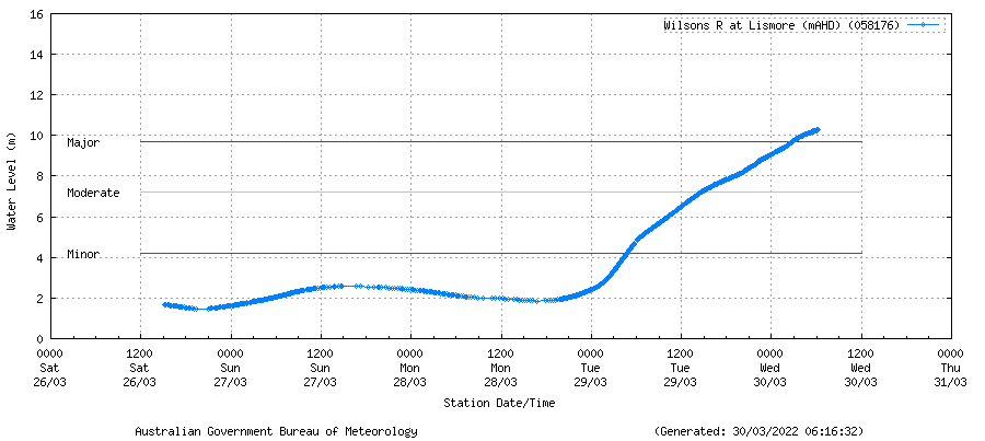
Image: Wilsons River level height observations showing the river level exceeding the major flood threshold at Lismore on Wednesday morning. Source: Bureau of Meteorology.
The low pressure system responsible for last night’s heavy rain and storms is likely to remain near northeast NSW on Wednesday, possible moving closer to the coast during the morning. This will cause more heavy rain, thunderstorms and potentially damaging winds in some areas. Eavans Head clocked a wind gust of 100 km/h at 6:20am.
At 7am AEDT, a severe weather warning was in place for heavy rain and damaging winds along the coast and adjacent inland between Murwillumbah and Forster. A severe thunderstorms warning was also in place for locally intense rainfall and flash flooding in parts of the Northern Rivers district, including Lismore, Byron Bay, Ballina and Alstonville.
Flood warnings are also being updated regularly as river level data becomes available across the region. You can find all the latest weather and flood warnings for NSW here.For more information, please contact us at apac.sales@dtn.com.


