Thick clouds, relentless rain and flooding are plaguing eastern NSW this morning, with Sydney now having its wettest start to a year on record. The composite satellite and radar animation below shows bands of rain lashing the central and southern coast and ranges of NSW on Tuesday morning.
The clouds and rain in the animation above can be seen circulating around a well-defined upper-level low positioned above the state’s Mid North Coast. To the south of this low, moisture-laden onshore winds are driving rain and thunderstorms into central and southern parts of NSW.
Widespread falls of 50 to 150 mm have been recorded between Port Macquarie and Green Cape during the last 24 hours, across an area covering about 700 km of the NSW coast and adjacent ranges. Isolated totals have been even higher in some areas, even exceeding 230 mm in the Illawarra.
The state’s heaviest rain in the 24 bours to 9am on Tuesday was at Mittagong, which received 232mm. This is more than two months’ worth of rain for Mittagong at this time of year.
Further north, Sydney’s Observatory Hill weather station copped 95.4 mm of rain during the 24 hours to 9am on Tuesday. This brings the city’s running annual total for 2022 up to 821.6mm, which is Sydney’s wettest start to a year on record, beating 782.8mm to the same date in 1956. Rainfall data at Sydney Observatory Hill dates back to 1858.

Prior to this last 24 hours, Sydney’s running annual total for 2022 (726.2mm) was sitting in third place behind 1956 (782.8mm) and 1990 (753.8mm).
Floods worsen as heavy rain continues
The heavy rain that has fallen in eastern NSW over the last 24 hours is exacerbating flooding across numerous catchments. Unfortunately, more heavy rain will fall throughout Tuesday as a surface-based low pressure system deepens near the NSW coast and tracks south.
The map below shows how much rain Australia’s high-resolution ACCESS-C forecast model is predicting on Tuesday.

Accumulated falls of around 50-150 mm are possible over parts of the coast and ranges between the Hunter and South Coast on Tuesday, with isolated falls in excess of 200 mm. Some of this heavy rain could fall over a short period of time, with 6-hourly rain rates possible exceeding 100 mm in some places.
Minor to Major flooding is already occurring across a broad area of eastern NSW and a flood watch has been issued for all NSW coastal rivers from the Mid North Coast to the South Coast.
Major flooding continues in western Sydney as water spilling from Warragamba Dam combines with heavy rain falling locally.

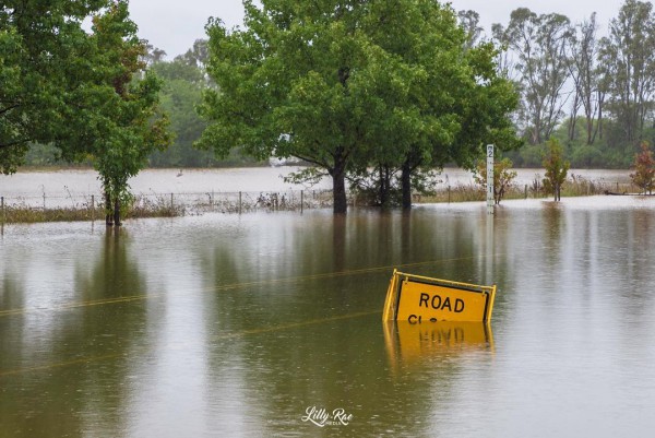
Image: Flooding in Camden on Tuesday, March 8. Source: @lillyraemedia / Instagram
On Tuesday morning, the Nepean River at Menangle Bridge was already experiencing major flooding that exceeded the levels seen there in March 2021. According to the Bureau of Meteorology, major flooding could also surpass March 2021 river levels in the Hawkesbury River at Windsor, Lower Portland and Wisemans Ferry, either on Tuesday or Wednesday.
Very heavy rain over an already sodden Georges River Catchment also caused moderate to major flooding at Liverpool and Milperra in Sydney’s southwest on Tuesday morning. Tens of thousands of residents were evacuated on Monday ahead of this flood, before the Georges River at Liverpool Bridge peaked at around 4.4 metres early Tuesday morning.

Image: The Georges River rose rapidly to a major flood peak early on Tuesday morning. Source: Bureau of Meteorology.
In addition to more heavy rain and flooding, eastern NSW will also be battered by damaging winds and damaging surf over the next couple of days as the low pressure system strengthens offshore.
Check the latest severe weather warnings, flood warnings and flood watches here for the most up-to-date information on this evolving weather event.
We understand the needs of Electricity and Gas Network Managers, that’s why our products give you accurate real-time monitoring of severe weather, allowing you to maximise resource allocation for repairs and maintenance. Our solutions are specified to how the weather will impact your network, rather than offering a broad and general forecast.
How can our innovative solutions help you? Our meteorological experts will take the time to understand your needs and then develop custom interfaces integrating all weather information into a single, easy to use interface. For more information, please contact us at apac.sales@dtn.com.


