
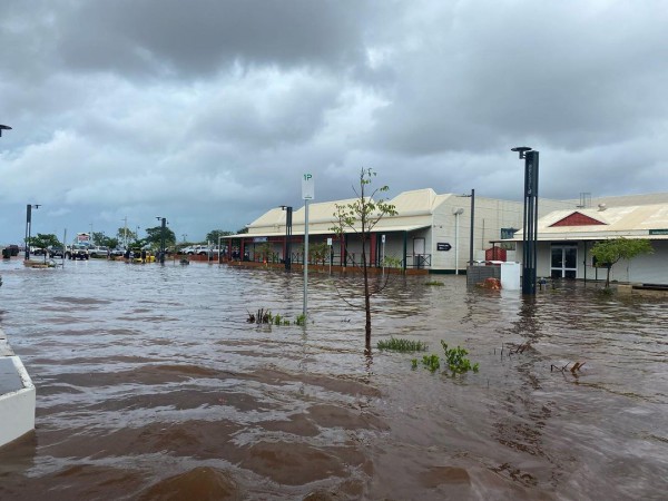
Parts of the Kimberley have been lashed with the heaviest rainfall in 120 years, with the multi- day deluge leaving towns, roads, and railways underwater.

Image: Flooding in Broome on Sunday, January 30, Source: @lauren.hall95
Businesses and residents across northern WA can expect heavy rainfall, thunderstorms, and damaging winds to continue as the monsoon trough and a low-pressure system deepen in the region.
The map below shows a deep low-pressure system over the Kimberley embedded within the monsoon trough, which is slowly moving southwest.

Image: Visible satellite image at 11:10am EDT on Tuesday, February 1, showing thick cloud over northern WA.
Broome Airport has recorded 326mm of rain since 9am Monday morning, with 48-hour totals reaching a 120-year high of 563mm. In just two days, Broome airport received more rain than during the whole of 2021.
To the east of Broome, Fitzroy crossing saw daily rainfall totals of 128mm to 9am Monday morning. Koolan Island also clocked a 102km/h damaging wind gust on Monday morning.
Damaging winds will continue to affect parts of the Kimberley, Pilbara and the northern interior on Tuesday, with gusts of 100km/h possible. The strongest winds are likely over the southwest Kimberley, where locally destructive gusts above 125 km/h are possible.
Heavy rainfall will also linger in these regions near the low-pressure system on Tuesday and early Wednesday. Daily rainfall totals of 100 to 200 mm are likely, with isolated falls in excess of 250mm.

Image: Access-G 24-hour rainfall totals to 8am Wednesday, February 2.
The rainfall will focus inland from Wednesday, as the low moves east briefly. Coastal locations such as Broome will notice a significant easing in the rain as this happens.
The low is expected to move off the Pilbara coast on Thursday night into Friday, with rainfall expected to ease slightly as it moves away from the area.
As the low moves off the northwest coast, there is a low chance at this stage of it developing into a tropical cyclone. However, at this stage, the low is expected to move towards the west and away from the Australian mainland after it moves offshore.
Weatherzone’s flood risk system
We have developed a flood risk system which accurately determines rainfall intensity at any given point along your mine site, catchment, road or railway.
The system uses radar technology which scans typically every 6-10 minutes, sending your business regular alerts or updates for your specific mine site or railway using geofencing technology.
Will the flood event subside, continue or worsen? The rainfall risk system is used in combination with Opticast™, an industry leading forecast system which forecasts rainfall intensity and accumulation at your location.
Weatherzone also provides businesses with long term rainfall forecasting solutions out to 6 months, which allows businesses to plan well in advance and reduce the impact on day-to-day operations. For more information, please contact us at apac.sales@dtn.com.




