Prosper in a dynamic world
Search

Heavy rain and severe thunderstorms set to impact northern Australia this week


The monsoon trough is deepening over northern Australia and is set to bring heavy rainfall and frequent gusty thunderstorms across this week. 

The deepening monsoon trough and associated convective activity have already caused and increase in rain and allowed a couple of low pressure systems to develop. 

One of these low pressure systems developed to the north of the Kimberley late last week. While there were indications that this low could become a tropical cyclone, this now looks unlikely, with the low’s proximity to land restricting its development. This low is expected to weaken on Monday and has a very low chance of developing into a tropical cyclone.  

The satellite image below shows another tropical low to the northwest of the Cocos Islands on Monday morning. This low may briefly move into Australia’s Western Region on Tuesday, before moving west again out of the region. This system will pose no direct threat the mainland of Australia and is also unlikely to develop into a tropical cyclone. 

 MicrosoftTeams-image (197)

Image: The satellite image shows another low to the northwest of the Cocos Islands, the green circle is highlighting its location. 

However, while tropical cyclones look unlikely this week, the lows and monsoonal trough are likely to enhance rainfall and bring severe storms to a broad area of northern Australia extending from the Kimberley, across the northern NT and into eastern tropical QLD. 

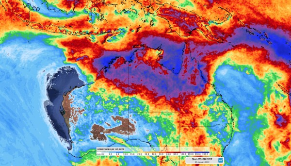
The image below shows this week’s forecast accumulated rainfall, with large rainfall totals expected across northern Australia. With active periods of the monsoon, widespread weekly rainfall totals will likely be more than 100 millimeters, with some places likely to see several hundred millimeters by the end of this week. 

 MicrosoftTeams-image (195)

Image: ECMWF weekly accumulated forecast rainfall to 11pm Sunday, January 30. 

The main threats during this week’s monsoon burst will be heavy rain, flooding, lightning and damaging winds. For more information on Weatherzone’s tropical cyclone, heavy rainfall alerting and thunderstorm forecasting, please contact us at apac.sales@dtn.com.

Latest news

Satisfy your weather obsession with these news headlines from around the nation, and the world.

El Niño Is Here: What a Potential Record Event Means for Southeast Asia and Australia

  El Niño was officially declared in June 2026, raising the prospect of widespread impacts across Southeast Asia, from extreme heat and water shortages to higher energy demand and agricultural stress.   The World Meteorological Organization has warned countries to “prepare for it to be severe”, while several global forecast models suggest the event could rank among […]

How El Niño will shape Australian port operations in winter-spring 2026

Australian ports and marine pilots can expect a season of shifting wind and swell patterns through winter and spring 2026, as a developing El Niño brings the likelihood of drier conditions and more variable operating windows across the country’s coastline.  Will El Niño develop in 2026?  There are clear signs that an El Niño pattern is becoming […]

From Kimberley to northern NSW: Bushfire outlook flags risk for resources sector this winter

Bushfire risk doesn’t usually make headlines in June, but AFAC’s winter seasonal outlook is putting mining and resources operators on alert from the Kimberley to the NSW.  Australia’s official seasonal bushfire outlook for winter 2026 was released by AFAC on Thursday, May 28. The outlook predicts increased fire risk across the northern parts of the Great Sandy Desert and surrounds […]

The signal was there weeks earlier: forecasting one of the year’s biggest wind events

In mid-May 2026, DTN APAC meteorologists flagged a strengthening Southern Ocean pattern in model guidance, signalling an extended run of record-challenging wind conditions across the NEM.  Nearly three weeks later, NEM wind generation climbed from around 1.5GW to more than 9GW, supplying roughly one-third of the grid and coming within 1GW of the all-time generation record.  The event highlighted […]