
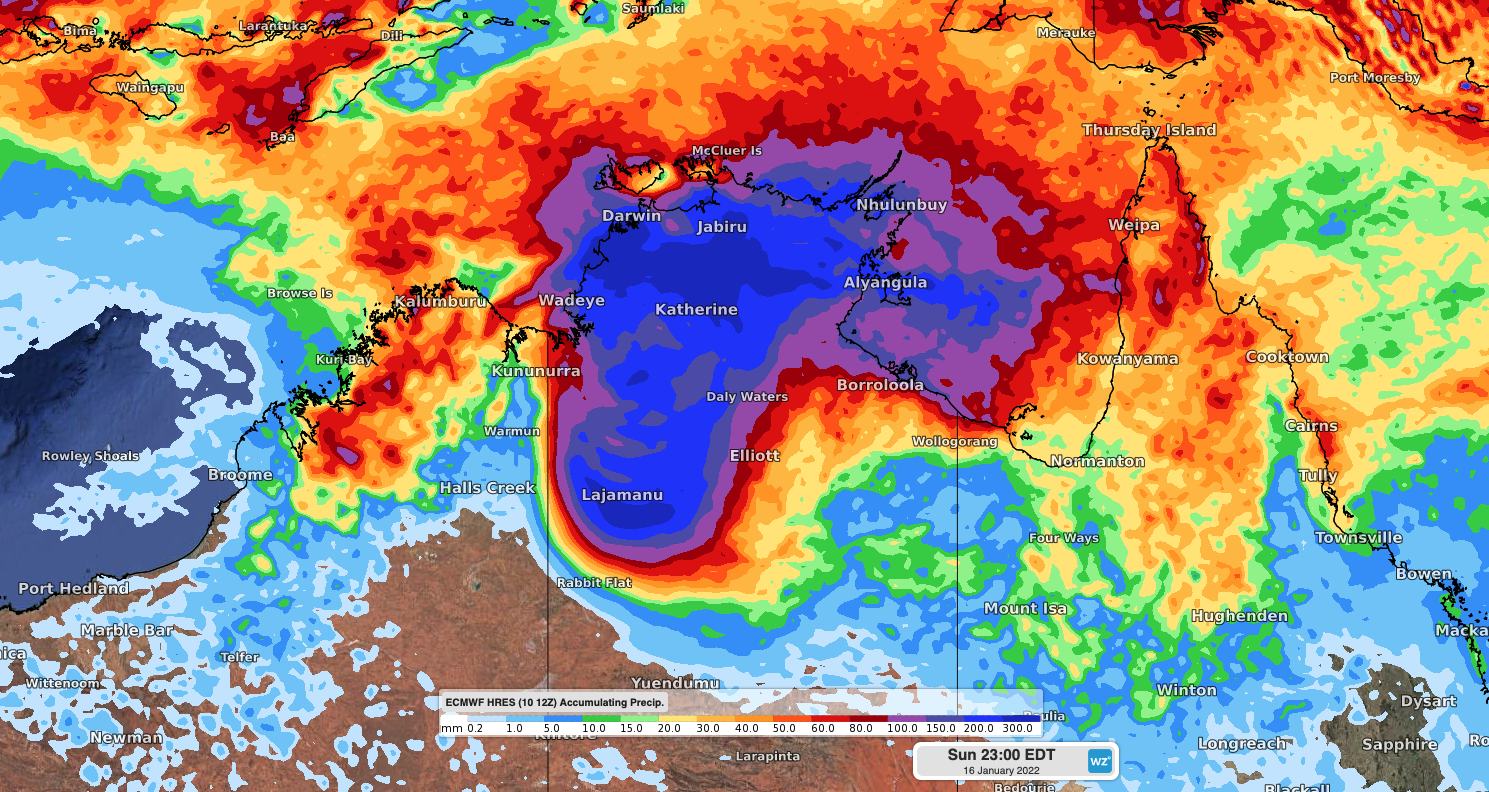
Ex-Tropical Cyclone Tiffany is likely to redevelop over the Gulf of Carpentaria today, before unleashing potentially destructive winds and several days of flooding rain in the NT.
Tropical Cyclone Tiffany formed over the Coral Sea on Sunday and made landfall to the south east of Coen, QLD on Monday. The tropical cyclone has since traversed Cape Yorke Peninsula and weekend to a Tropical Low, located in the eastern Gulf of Carpentaria on Tuesday morning.
The satellite animation below shows thunderstorms erupting over the Gulf of Carpentaria on Tuesday morning as ex-Tropical Cyclone Tiffany moved off the west coast of Cape York Peninsula.
Video: Visible satellite image sequence showing thunderstroms forming to the west of ex-Tropical Cyclone Tiffany on Tuesday morning. Source: RAMMB/CIRA SLIDER
With the system now tracking over warm water in the Gulf, the Tropical Low is like to reintensity into a tropical cyclone on Tuesday.
At this stage, Tiffany is expected to drift west and reach Groote Eylandt as a category two tropical cyclone on Wednesday.
Based on current modelling, very destructive wind gusts of around 140 km/h are possible near the eye wall of Tropical Cyclone Tiffany when it strikes Groote Eylandt on Wednesday morning.
Gale force winds, with gusts to around 100km/h, are also possible along the NT coast between Nhulunbuy and the QLD/NT border on Wednesday, most likely from the afternoon. Gusts could still be exceeding 125km/h near the center of Tiffany as it crosses the coast of the NT mainland.
In addition to this dangerous wind, heavy rain and potentially severe thunderstorms will spread over the eastern Top End, including Groote Eylandt, from today into Wednesday. This may cause flooding in low lying areas and river rises.
Most forecast models now agree that after making landfall on Wednesday, the remnants of Tropical Cyclone Tiffany will move over the northern inland of the NT and linger there for several days.
While over land, the remnants of Tiffany will continue to drag tropical moisture over the NT and convert it into rain and thunderstorms. This setup has the potential to produce prolonged heavy rain over the northern and central districts of the NT.
Multi-day accumulated rainfall totals of 100-300mm are possible between about Thursday and Sunday, with some areas at risk of receiving more than half a metre of rain over three days.

Image: Forecast accumulated rain between Tuesday and Sunday, according to the ECMWF-HRES model.
This much rain would cause widespread flooding that could cut off major outback roads, disrupt travel and isolate communities for days or even weeks.
The upcoming rainfall may be similar in some ways to January 1998, when the remnants of Tropical Cyclone Les inundated the Top End after drifting in from the Gulf of Carpentaria.
A flood watch has been issued in the NT and tropical cyclone watches and warnings are being updated regularly. You can find information about how to prepare for a tropical cyclone here.
Weatherzone will continue to monitor Tropical Cyclone Tiffany closely over the coming week and bring daily updates on its development. Be sure to check the latest warnings and forecasts for the most up to date information if you live in northern QLD or the NT. For more information on Weatherzone’ tropical cyclone forecasts and risk analysis, please contact us at apac.sales@dtn.com.




