
During Australia’s black summer of 2019/2020 7.4 million hectares of land burned. The fires were fuelled by prevalent dry and warm north-westerly winds, lightning, extreme temperatures, heatwaves, and below average rainfall.
The Climate and Atmospheric Science journal reported that a “super-outbreak” of fire thunderstorms during Australia’s Black Summer released the energy of about 2,000 Hiroshima-sized nuclear weapons.
While we had some respite last summer due to La Nina, the Northern hemisphere has been battling with a bad fire season in theirs. The current fires in Siberia, Canada, California as well as our black summer fires in 2019/20 have something in common, they have all generated pyrocumulonimbus.
Pyrocumulonimbus or fire storm is created when a bushfire becomes so intense that it changes the surrounding atmosphere, building a distinctive, anvil-shaped cumulonimbus cloud high above the fire.
Thunderstorms are known to generate strong and variable wind gusts which often make fighting the fires even more difficult. Not to mention the danger of lightning, which can light additional spot fires nearby. Firefighting aircraft also have trouble in thunderstorms, due to the turbulent nature of the atmosphere (Figure 1).
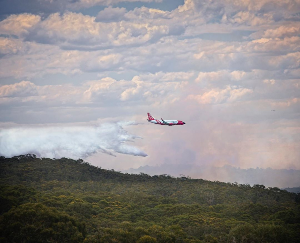 Figure 1: Aircraft waterbombing the fire in the NSW Royal National Park on the October 11, 2020. Source: @malibumedia
Yes, large bushfires often change the weather around them. But they may also be powerful enough to affect the climate. The rising air in thunderstorms can transport smoke and ash as high up as the stratosphere.
When that much smoke and ash is released into the atmosphere, it travels into the stratosphere (up to about 50 km above the earth’s surface. In the case of Australia’s Black Summer, the smoke remained there for as much as a year and was transported across the Tasman Sea.
The effects on climate of all that smoke and ash are not yet fully understood. Potentially, it could temporarily cool the climate, creating a similar effect to “volcanic winters” which have occurred in the past when particles from huge eruptions blocked direct sunlight.
Pyrocumulonimbus is yet another phenomenon that our meteorologists do watch out for in the summer. For more information on our fire and climate services, please contact us at apac.sales@dtn.com.




