
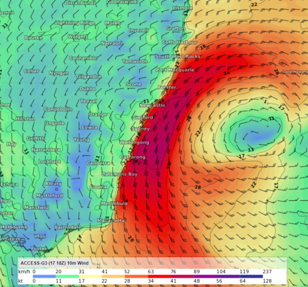
A deepening Tasman Low will bring a burst of wind, rain, and large waves to parts of Tasmania, Victoria, and NSW during the next 3 days.
The low could be seen clearly in satellite images last night, sitting roughly 350 km to the east of Victoria and is expected to deepen today and tomorrow.
WAVES
The low is expected to whip up a surge of large and dangerous waves, which will affect coastal areas from Tasmania up to northern NSW between Friday and Sunday.
Waves are expected to peak on Saturday, reaching 5-6 metres. There is potential for the heavy surf to generate coastal erosion and localised damage. The waves will gradually decline on Sunday to around 3-4 metres by the end of the day.
WIND
The strongest wind and heaviest rain will target eastern Tasmania, eastern Victoria and southeastern NSW during Friday and Saturday. Mainly along the coastal fringe.
Winds are predicted to increase along the central and southern NSW coastline this afternoon and evening. However, the strongest winds are expected to impact the NSW coastal fringe south of Seal Rocks during Saturday.
The damaging winds are expected to begin during Saturday morning along the South Coast of NSW, before pushing up the coastline as the Tasman Low extends a trough up the coastline.
The damaging winds are modelled to average 25-35 knots (about 45-65 km/h), with peak gusts reaching 35-45 knots (about 65-85 km/h).
Coastal showers and the possibility of thunderstorms may bring gusts in excess of 48 knots (90km/h) as they move over the coastal fringe of southeastern NSW.
RAIN
The heaviest rain will target eastern Tasmania, eastern Victoria and southeastern NSW on Friday and central eastern NSW on Saturday.
Some areas could see 20-40mm of rain, with flood watches and minor flood warnings already in place for parts of eastern Tasmania and the East Gippsland region in Victoria.
Sydney is predicted to see 20-40mm in the eastern suburbs from Friday evening until Sunday, while the western suburbs are not likely to observe these totals.
Temperatures across southeastern Australia are expected to drop to 1-2 degrees below average. The temperatures, high winds and rainfall will increase the chill factor for people over the weekend.
Wind and rain will ease later Sunday as the low-pressure system moves out over the Tasman Sea.
Our Meteorologists here at Weatherzone provide consultation and 7-day detailed forecasts for businesses that may be impacted by events such as this. Our operational forecast summary shows a high impact on operations during the next 3 days for a port. For more information, please contact us at apac.sales@dtn.com.




