
Prosper in a dynamic world
Search

Is there a lack of radar coverage at your location? Oracle can help fill the gaps.


Radar coverage is sparse across regional Australia, much to the frustration of miners and local communities. This is because radars are typically placed near the coast, where much of Australia lives. Unfortunately, they can only detect rainfall within a 256 kilometre radius, leaving many areas without coverage.

Significant rainfall was observed in the Pilbara last week, which was not covered by your stock standard radar. The holes in the coverage through regional Western Australia are noticeably clear.


Weatherzone has the solution, and its name is Oracle.

Oracle is a new ‘radar’ system, which enables users to see rain as its happening anywhere in the world. In addition to tracking current rain, Oracle also provides live forecasts of rainfall rates, lightning, and cloud for up to three hours in advance, for anywhere in the world.

It does this by feeding live satellite imagery, lightning data and nearby radar imagery into the forecast system. This cutting-edge technology was built in collaboration with Solcast.

Oracle certainly hit the nail on the head last week, with Oracle rainfall rates of 40mm/hr shown near the Tom Price area (yellow shade figure 2).

But how did this compare to the rainfall observed on the ground at weather stations?

Rainfall observation sites on the ground near Tom Price, WA, have received between 39-41mm in the 24 hours leading up to 9am last Wednesday, 5 May (boxes with rainfall observation numbers in figure 2).
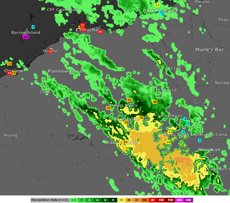
 

Figure 2: Oracle observed rainfall rates (shading) on Wednesday 5 May 8:05am (am or pm) WST. The boxes with numbers are rainfall observations since 9am on the 4 May.

Oracle is a more than adequate replacement for radar, but the genius of it is also a one-of-a-kind forecast system, delivering accurate forecasts out to 4 hours. Stay tuned for additional updates on Oracles new forecasting capabilities. For more information, please contact us at apac.sales@dtn.com.


Latest news

Satisfy your weather obsession with these news headlines from around the nation, and the world.

A warm, light wind spring ahead for the NEM

A strong El Niño and an unusually stable Antarctic polar vortex are setting up a spring signal of light winds, elevated solar output, and a real risk of high-intensity heatwaves for the NEM.   This forecast could be a major flip to what the National Electricity Market (NEM) has experienced so far during Winter 2026. On 1 July 2026, the NEM […]

Habagat and successive typhoons trigger widespread flooding in the Philippines

Three consecutive weeks of enhanced southwest monsoon (Habagat) and back-to-back typhoons have flooded Luzon and the Visayas, grounding flights, triggering distribution power outages, cutting off transport corridors, and raising landslide risk across mining-dense provinces like Benguet and the Cordillera. The disruption is far from over with PAGASA expecting the monsoon to remain in place until […]

Australia’s Spring 2026 Bushfire Outlook: Increased Risk Across Seven States and Territories

Fire agencies, land managers and businesses are being urged to prepare as the AFAC spring seasonal bushfire outlook, released on August 19, 2026, warns of elevated bushfire risk across Australia this season. The outlook identifies above-average fire danger across seven states and territories, with conditions driven by a combination of elevated fuel loads, an El Niño […]

Businesses under pressure: how this powerful high will affect Australian industries

A very strong high pressure system centred over Tasmania will impact southern and eastern Australia’s weather over the coming days. How strong is this high pressure system? Mean Sea Level Pressure (MSLP) has already reached 1039.3 hPa at Ouse, Tasmania on Sunday morning, and is forecast to peak at 1041 or 1042 hPa on Monday […]


