Albany Wind Farm near the town of Albany , Western Australia.
Low wind power during October 2020
During the past month, a positive Southern Annular Mode (SAM) (Figure 1), has been promoting below normal wind power for much of the National Electricity Market (NEM). The SAM refers to the north-south shift of westerly weather systems/fronts in the Southern Ocean compared to their usual position. Periods of positive SAM typically bring less wind generation and greater potential for heat waves at the same time, due to the dominance of high pressure near southern Australia.
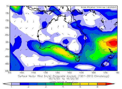
High pressure anomalies near the Southern Ocean and Great Australian Bight, and associated light winds over much of the NEM, were observed during October (Figure 2 and 3).
The onshore winds along Australia’s east coast (shown in Figure 3) are typical in periods of positive SAM.These onshore winds also promote cloud and precipitation along the east coast.
Spring and Summer NEM wind power forecast
A positive SAM is forecast to continue into November (see Figure 1), promoting periods of light wind power for the NEM.
In addition to the SAM, La Niña thresholds were met in the tropical Pacific Ocean and the overlying atmosphere in late September. This La Niña is forecast to reach a peak around December and continue until at least February 2021.
La Niña is well known for generating increased cloud and rainfall in Australia during spring and summer, particularly in eastern states. Reduced daytime temperatures are forecast during this La Niña event due to increased cloud cover, with a reduced risk of extreme temperatures also likely this summer.
La Niña is also directly correlated to periods of positive SAM. Research has shown that positive SAM events occur four times as often during La Niña. Periods of positive SAM are likely to shift frontal features further south than normal, promoting high pressure across the Southern Ocean and reduced wind power for the NEM. Positive SAM can also increase the risk of heatwaves for the southern coastal cities, including Adelaide and Melbourne. This is quite a contrast to the spring and early summer period we saw last year, during which a negative SAM created abnormally windy, warm and dry conditions for the NEM.
Below normal wind power is predicted over much of the NEM during summer, due largely to increased periods of positive SAM. However, low pressure anomalies over South Australia during the remainder of spring and summer may still promote periods of increased wind power for the South Australian wind farms at times.
For more information on Weatherzone’s services, wind power products and to ask any questions please email us on apac.sales@dtn.com.


