Australia has just experienced a highly impactful tropical cyclone season, with more than 60% of systems reaching severe intensity, causing widespread disruption and damage to communities and multiple industries across northern Australia.
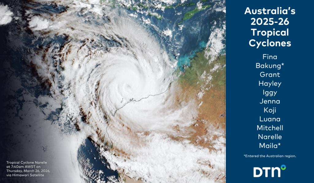
The 2025–26 Australian tropical cyclone season officially ran from 1 November 2025 to 30 April 2026. During this six-month period, Australia saw 11 tropical cyclones, with nine forming within the Australian region and two forming outside of Australia’s area of responsibility. Five of these systems made landfall, bringing severe weather to parts of the country.
While eleven cyclones is slightly above the long-term average of 9.5 systems, the season was notable for an unusually high proportion of severe cyclones forming in the region. Of the eleven cyclones, seven systems reached severe intensity (Category 3 or higher), compared to a historical average of approximately 4–5 severe cyclones per season.
The seven severe systems of the 2025–26 season were Narelle (Cat 5), Maila (Cat 5), Fina (Cat 4), Bakung (Cat 4), Hayley (Cat 4), Jenna (Cat 4), and Mitchell (Cat 3). Of the seven severe tropical cyclones, four made landfall on the Australian mainland, with Narelle notably crossing the coast multiple times across different states/territories.
Cyclone activity during the season was not evenly distributed, with peak periods occurring during monsoon onsets and when tropical pulses such as the Madden–Julian Oscillation (MJO) were active. The most active period occurred between February and March 2026, when the monsoon trough, MJO and warm ocean temperatures coincided.
Wet season
The season also delivered above-average wet season rainfall across northern Australia, driven by monsoon lows, tropical cyclones and the background influence of warm SSTs and La Niña. Pockets of far north Queensland, the western Top End and the Kimberley in WA saw the highest rainfall on record.
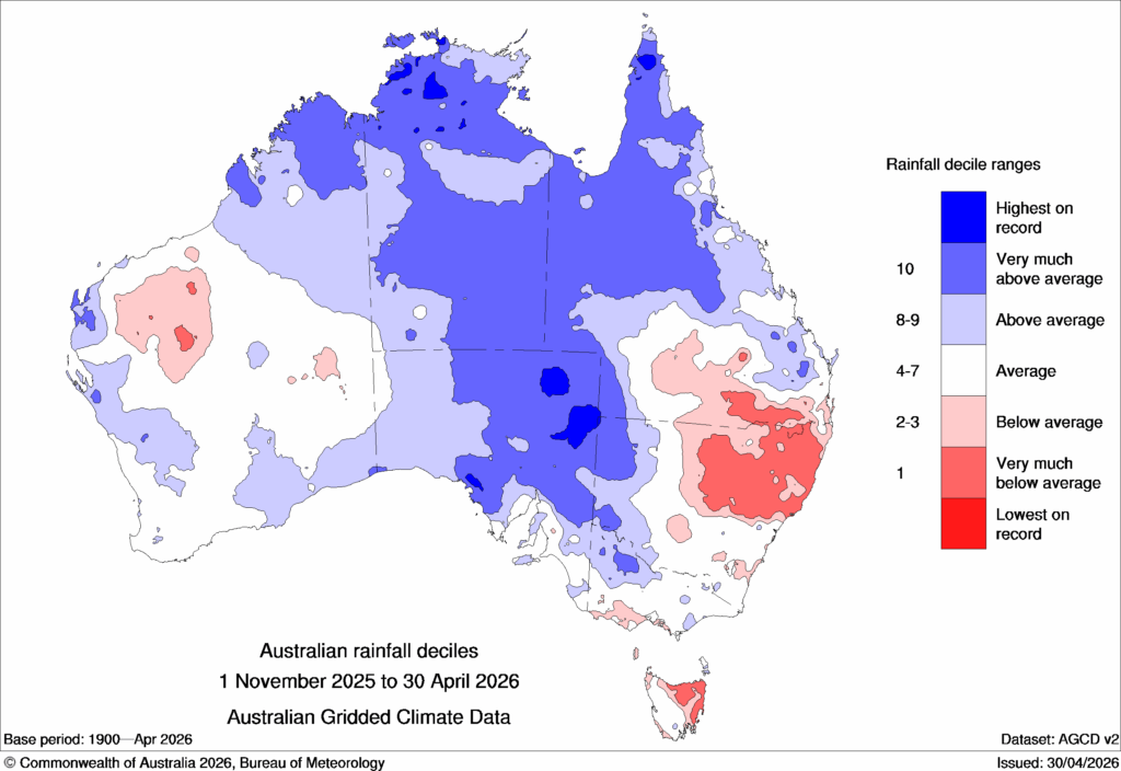
Image: Australian rainfall deciles between 1 November 2025 to 30 April 2026, source: Bureau of Meteorology
The Top End wet season officially runs from the start of October to the end of April. To 9am this Thursday, April 30 (in the unlikely event of rain after 9am, it will be counted in May’s total) Darwin recorded:
- 2397.4mm of rainfall across the wet season, which made it the 4th-wettest on record.
- The average across the season in 157 years of records is 1691.7mm.
- Above-average rainfall in each of the last six months of the season from November through April. The only other time that happened was in 2016/17.
Persistent rainfall events limited recovery windows between systems, increasing flood risk, while frequent thunderstorm activity introduced additional hazards including lightning, damaging winds, and intense rainfall rates—compounding operational disruption for weather-sensitive industries.
Climate drivers
The intense season occurred under the combined influence of above-average sea surface temperatures (SSTs), a warming climate background, and a La Niña event declared by the Bureau of Meteorology on 27 November, which persisted into early April 2026.
Additionally, exceptionally warm oceans surrounding northern Australia—approximately 1 to 3°C above average in key regions—provided significant additional energy for cyclone development. This was the dominant driver of intensity, supporting:
- Rapid intensification events
- Higher peak cyclone intensity
- Longer-lived severe systems
The northern Australian monsoon arrived earlier than usual on 23 December 2025, marking the first active phase of the wet season -typical of La Niña years, which often see an earlier onset.
Once established, the monsoon became highly active and moisture-rich, contributing significantly to both rainfall and cyclone development.
Tropical cyclones and monsoonal lows also contributed significantly to seasonal rainfall totals, particularly inland, with above to very much above average rainfall observed across northern Australia.
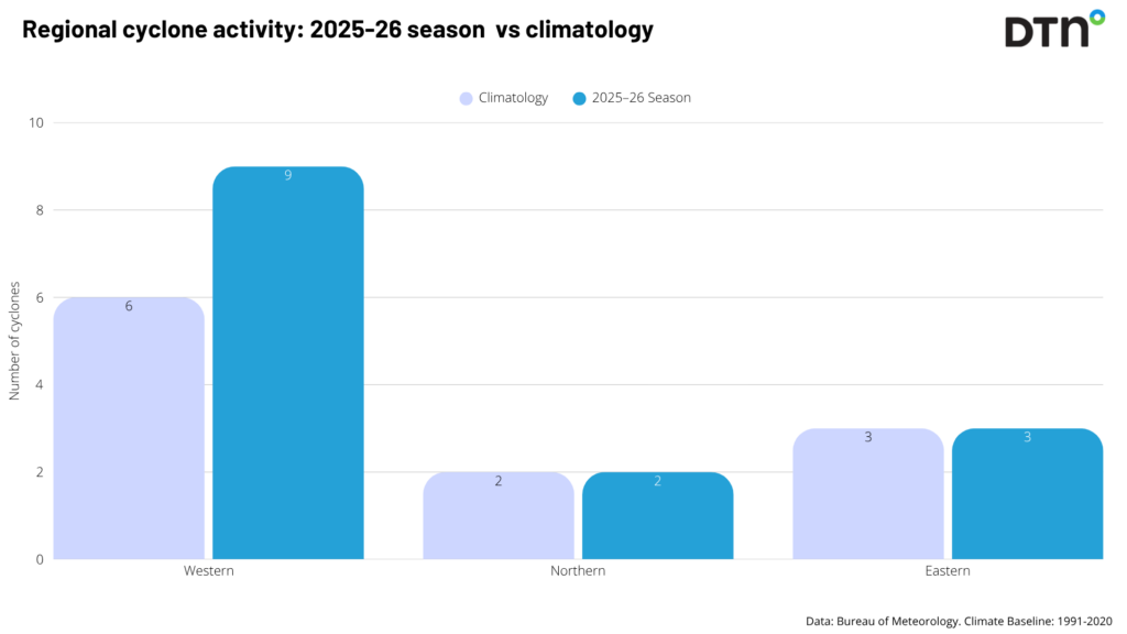
Regional distribution vs climatology
The 2025–26 season broadly followed the typical spatial pattern; however, the western region saw more cyclones than normal with nine forming or moving into the area.
Cyclone trend in Australia: fewer cyclones, greater intensity
The number of tropical cyclones in the Australian region has decreased in recent decades, with an average reduction of around one system every 11 years since 1980, likely linked to broader climate change influences.
This long-term decline also reflects strong ENSO variability, with La Niña years typically producing more cyclones, while El Niño years are associated with fewer systems.
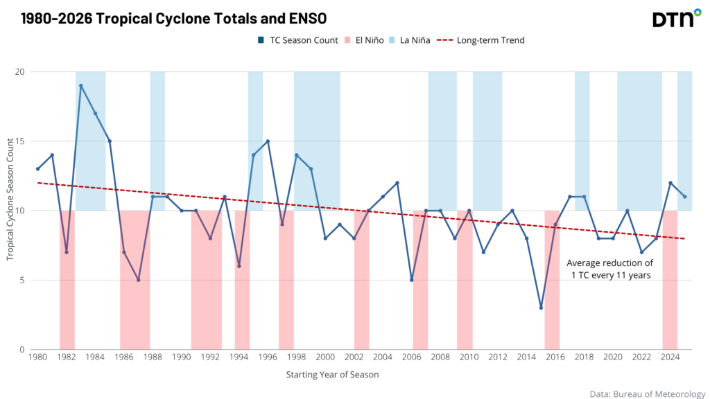
While total cyclone numbers are decreasing, the proportion of severe cyclones is increasing. Warmer ocean temperatures are a key driver of this trend, supporting more frequent rapid intensification and higher peak intensities.
Forecast performance and operational response
Ahead of the season, DTN APAC’s seasonal outlooks accurately projected a slightly above-average number of cyclones, alongside an elevated risk of severe systems, communicated through detailed briefings to clients across northern Australia.
The impactful season meant that our team of risk communicators provided extensive support to clients, including:
- 96 tropical cyclone briefings
- 1,750 email advisories
This reflects sustained engagement across multiple cyclone events and prolonged impacts.
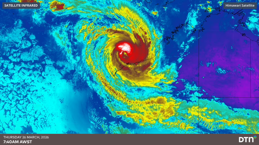
Tropical Cyclone Narelle- the most impactful system of the season
Tropical Cyclone Narelle accounted for a disproportionate share of operational activity due to its duration and multi-region impact. It is highly unusual for a system to cross three Australian jurisdictions (Queensland, the Northern Territory, and Western Australia), making Narelle a rare “triple-impact” cyclone.
This type of track is extremely uncommon in modern records. Narelle became the first tropical cyclone since 2005 to make landfall in three Australian states while maintaining tropical cyclone intensity, with the only other comparable cases since 1980 being Cyclone Ingrid (2005) and Cyclone Steve (2000).
Narelle reached severe intensity across three Australian states and territories, with our meteorologists supporting exposed clients with the following;
- 48 briefings (~50% of seasonal total)
- 790 advisories
Narelle highlights how a single long-track system can dominate seasonal risk exposure.
With climate change, this shift toward fewer but more powerful systems is becoming increasingly important for forecasting, planning, and operational resilience across weather-sensitive industries.
Through our weather intelligence and risk communication services, DTN APAC helps businesses prepare for and respond to severe weather impacts, including tropical cyclones, intense rainfall. For more information, take a look at our 7-Day Tropical Cyclone Service and Risk Communicators.


