
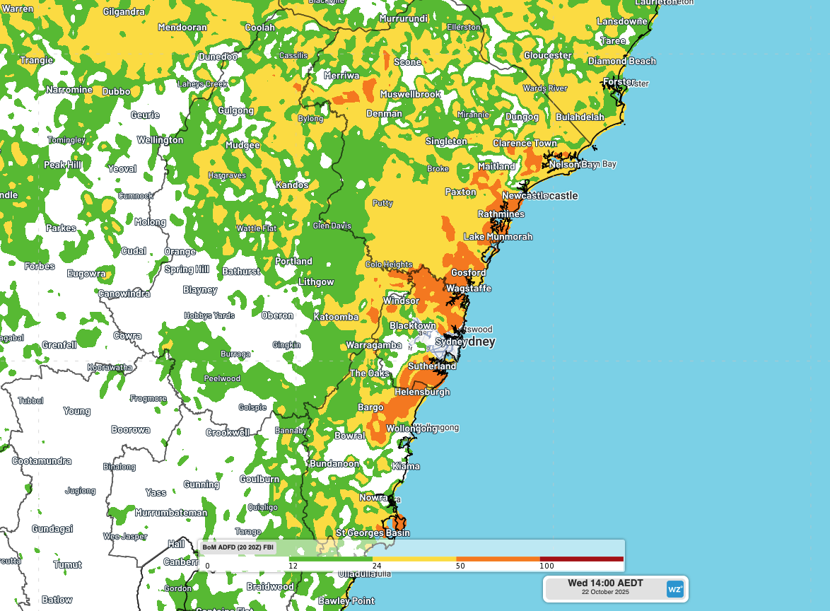
A burst of record-challenging October heat and blustery winds will cause Extreme fire danger ratings and Total Fire Bans over parts of NSW on Wednesday, including Sydney.
Clear skies and dry air have allowed intense heat to build over western NSW, southern Queensland and northern SA in the last few days.
On Monday, the temperature soared to 44.9°C at Birdsville in Queensland’s Channel Country. This was surpassed on Tuesday when the mercury reached 46.1°C shortly before 2:30pm AEST, setting a new October record for the state.
Tuesday was also exceptionally hot in far western NSW, with Bourke reaching 44.3°C shortly after 3:30pm AEDT. This was also a new October record for NSW.
This sweltering inland heat will be flushed towards Australia’s east coast on Wednesday as northwesterly winds strengthen ahead of an approaching cold front and low pressure trough.
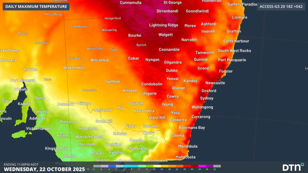
Image: Forecast maximum temperature on Wednesday, October 22, 2025.
The tongue of intense heat sweeping over NSW on Wednesday will see temperatures climb more than 15°C above average for this time of year in the state’s east, with October records likely to be challenged.
Sydney is forecast to reach 38°C in the city on Wednesday, which is 16°C above average for the middle of spring. The city’s October maximum temperature record – currently 38.2°C set in 2004 – may even be challenged. Some of Sydney’s western suburbs could get close to 40°C.
Wednesday’s intense heat will combine with fresh to strong northwesterly winds, resulting in Extreme fire danger ratings and Total Fire Bans for parts of central and eastern NSW.
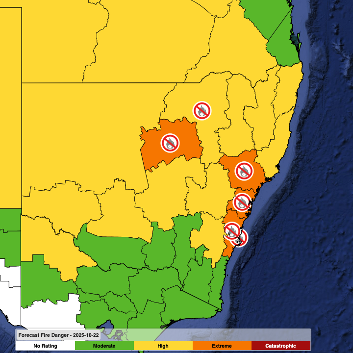
Image: Forecast fire danger ratings and Total Fire Bans on Wednesday, October 22, 2025.
Firefighters in NSW and southwest Queensland will also be keeping a close eye on thunderstorms on Wednesday. There is a risk that storms associated with the low pressure trough will cause dry lightning, which could ignite fires amid the hot and windy conditions. Thunderstorms are possible over most of NSW on Wednesday, except for the state’s northeast.
How DTN APAC Services Fire-Prone Outdoor Industries
Working in often challenging conditions across high-risk outdoor operations including forestry, emergency services, mining, rail, and utilities, our consolidated weather services ensure full situational awareness for you and your team.
DTN APAC serves fire-prone outdoor industries, delivering trusted weather data and severe weather alerting to maintain safety, protect your assets and underpin your operational planning.
Reinforce your Prevention, Preparedness, Response and Recovery (PPRR) efforts with our tailored services.
Prevention: Utilise our seasonal outlooks and daily forecasting to identify and implement prevention measures. Understand the climate risks affecting your operations. Calculate optimal timing for maintenance activities, vegetation management, and scheduled shutdowns.
Preparedness: Gain understanding of bushfire risk in the days, weeks and months leading up to peak fire season. Use DTN APAC’s seasonal outlooks and 14-day forecasting to plan workforce deployment, equipment positioning, and preventative operations such as controlled burns or asset maintenance.
Response: We deliver fire danger forecasts and provide nowcasting and forecasting of severe weather events, including thunderstorm/lightning detection and alerting, to give you full situational awareness of emergency conditions likely to impact your operations and infrastructure.
Recovery: Assess the weather risks affecting post-incident recovery and restoration processes. Utilise post-event analysis reports to support insurance claims, evaluate operational response effectiveness, and inform future risk management strategies.
We work to bring you full situational awareness so you can mitigate risk, ensure workforce safety, and maintain operational continuity across your outdoor assets.
Learn more about our large range of industry leading products and services or email us at sales.apac@dtn.com
See our Case Study on how Tasmania Fire Service (TFS) improved lightning detection and continued optimising preparations for challenging fire seasons ahead with DTN APAC’s full suite of solutions.




