
Intense thunderstorms are likely to pummel parts of NSW on Friday, with damaging winds, large hail and heavy rain all a risk for mining, transport, insurance and aviation sectors.
A cold front and associated low pressure trough will sweep across NSW on Friday, causing a relatively cool air mass travelling from the south to clash with a much warmer air mass over NSW.
An upper-level trough passing over southeastern Australia on Friday will also help to destabilise the atmosphere, resulting in an outbreak of thunderstorms across central and northeastern parts of the state.
A few isolated showers and storms will develop over the state’s south and west early on Friday. However, the day’s main thunderstorm activity will build over central NSW from the late morning and early afternoon, including Sydney, before spreading into the state’s northeast in the afternoon and evening
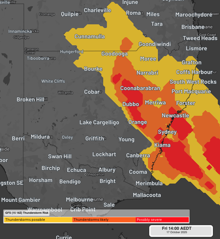
Image: Forecast thunderstorm risk on Friday afternoon, showing the areas that could experience thunderstorms, some of which could become severe, as seen on the DTN APAC Stormtracker Dashboard.
Sydney will be dry and warm on Friday morning and is forecast to reach a top of 32°C in the afternoon, which would make it the city’s warmest day since March. This heat could help storms develop over the Sydney Basin in the afternoon and evening.
Damaging winds and large hail will be the main threats with any severe storms in NSW on Friday – threatening power utilities, insurance claims and outdoor workers. Heavy rain and flooding are less of a risk compared to wind and hail, although isolated bursts of intense rain are likely under some storm cells.
Isolated supercell thunderstorms are also possible on Friday, particularly over central eastern NSW – possibly affecting mining areas over the region. If these supercells do form, they may cause destructive wind gusts in excess of 125 km/h and giant hail measuring more than 5cm in diameter.
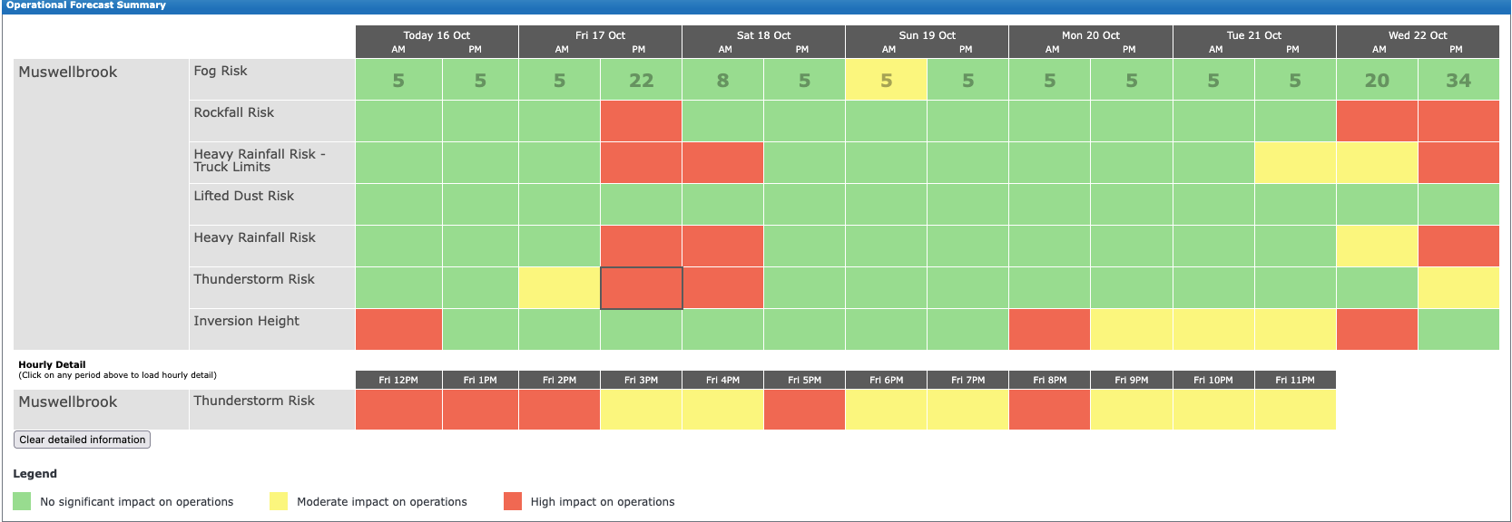
Image: DTN APAC’s Operational Forecast Summary highlighting the risk of ‘High impact on operations’ from heavy rainfall and thunderstorms on Friday afternoon for mining operations in the Hunter region.
Severe thunderstorm warnings will be issued throughout Friday as storms develop across the state. Be sure to check the latest warnings in your area using the Stormtracker dashboard, particularly in the afternoon and evening.
How DTN APAC’s Stormtracker can help your business
Embedded in DTN APAC’s industry interfaces, the system gives you a time advantage when monitoring conditions developing over your infrastructure and location.
Stormtracker is our Global Information System (GIS) tracking tool, providing multiple weather layers and zoom controls overlaid on a map of your location and infrastructure. You can choose a snapshot or full screen view, depending on your requirements. The maps allow you to monitor all weather, and specifically any systems likely to cause risk for your business. You also have the capacity to observe:
- real time lightning and thunderstorm alerts
- localised lightning strike frequency
- official warnings for storm, cyclone, wind, flood and fire
- sentinel hotspot fires and fire agency current incidents
Stormtracker’s radar imagery updates every 5 minutes, so you are always able to respond rapidly to changing conditions. You can customise alerting to notify you when your staff or infrastructure are under threat. With increased situational awareness, your ability to make informed decisions quickly is optimised.
DTN APAC’s experience and intelligence gives you a clear path through complex situations. Let us assist you, offering actionable insight when extreme weather poses risk to your business.
Learn more about our large range of industry leading products and services or email us at sales.apac@dtn.com
Thumbnail image source: iStock / Philip Thurston.


