Parts of southeast Queensland just had a remarkably dry start to spring, with Brisbane registering its driest September since 1987, increasing the risk of elevated bushfire danger into October.
Rainfall was variable across Queensland in September as cloudbands and bursts of tropical moisture delivered healthy totals in the state’s southwest and northeast, while a broad corridor of lacklustre rainfall stretched from the southeast to the northwest.
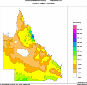
Image: Observed rainfall during September 2025. Source: Bureau of Meteorology.
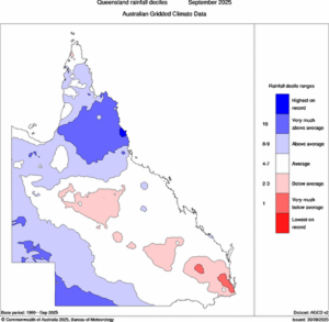
Image: Observed rainfall anomalies during September 2025. Source: Bureau of Meteorology.
Brisbane only collected 0.8 mm of rain through the entire month, making it the city’s driest September in 38 years and its 4th driest in records dating back to 1840.
Townsville also only received 0.8 mm during the month, although this was more than the 0 mm they saw in September last year.
A number of locations further inland had no rain at all this September, including Blackall, Hughenden and Richmond, but this wasn’t the first rainless September for these places.
One area that saw lots of rain this September was the North Tropical Coast, where a six-day deluge in the middle of the month dumped more than 600 mm of rain in some areas. This was a remarkable period of rain considering September is typically the region’s driest month of the year. Topaz’s 701 mm, Innisfail Airport’s 351 mm and South Johnstone’s 320 mm were standout monthly totals in the region. For South Johnstone, this was more than three times its monthly average and the wettest September in 27 years. In Topaz, more than 370 mm fell in a single day.
Cairns Airport received 148.4 mm in September, while the Cairns Racecourse rain gauge picked up 273 mm. This amounted to the wettest September since the mid-1800s in Cairns.
September’s variable rainfall across Queensland will affect bush and grass fire potential through the middle of spring. Areas that were dry in September, including the state’s southeast and central inland, will have heightened fire potential in October due to enhanced curing boosting early-season fire fuel loads.
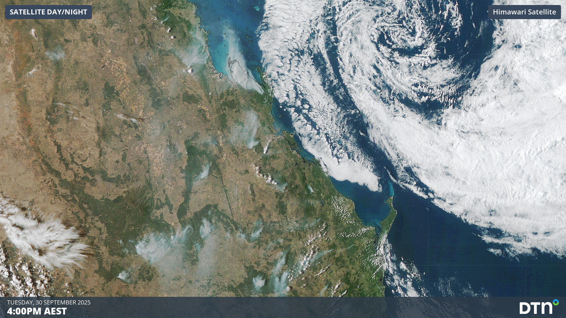
Image: Satellite images showing fires in southeast and central Queensland on Tuesday, September 30, 2025.
Satellite images captured on Tuesday showed numerous fires causing large smoke plumes across the Maranoa and Warrego, Central Highlands and Coalfields, Darling Downs and Granite Belt, and Wide Bay and Burnett Districts. Large fires like these ones will be a frequent sight on the skyline until the parched landscape receives decent rainfall.
How DTN APAC Services Fire-Prone Outdoor Industries
Working in often challenging conditions across high-risk outdoor operations including forestry, emergency services, mining, rail, and utilities, our consolidated weather services ensure full situational awareness for you and your team.
DTN APAC serves fire-prone outdoor industries, delivering trusted weather data and severe weather alerting to maintain safety, protect your assets and underpin your operational planning.
Reinforce your Prevention, Preparedness, Response and Recovery (PPRR) efforts with our tailored services.
Prevention: Utilise our seasonal outlooks and daily forecasting to identify and implement prevention measures. Understand the climate risks affecting your operations. Calculate optimal timing for maintenance activities, vegetation management, and scheduled shutdowns.
Preparedness: Gain understanding of bushfire risk in the days, weeks and months leading up to peak fire season. Use DTN APAC’s seasonal outlooks and 14-day forecasting to plan workforce deployment, equipment positioning, and preventative operations such as controlled burns or asset maintenance.
Response: We deliver fire danger forecasts and provide nowcasting and forecasting of severe weather events, including thunderstorm/lightning detection and alerting, to give you full situational awareness of emergency conditions likely to impact your operations and infrastructure.
Recovery: Assess the weather risks affecting post-incident recovery and restoration processes. Utilise post-event analysis reports to support insurance claims, evaluate operational response effectiveness, and inform future risk management strategies.
We work to bring you full situational awareness so you can mitigate risk, ensure workforce safety, and maintain operational continuity across your outdoor assets.
Learn more about our large range of industry leading products and services or email us at sales.apac@dtn.com


