
Huge Southern Ocean swells generated by a series of cold fronts are bearing down on three of Australia’s coastlines, and parts of Indonesia and the Pacific.
Vigorous cold fronts to the south and southwest of Australia have been generating gale to storm force winds over the past few days. Gale force winds can be estimated to have been blowing over an area greater than the landmass of Western Australia at times during Tuesday.
Video: Cold fronts to the southwest of Australia on Wednesday, July 16, 2025.
Huge seas exceeding 10 metres have been generated within the core of the storm, with wave heights exceeding 5 metres extending west and south of Tasmania nearly to Africa.
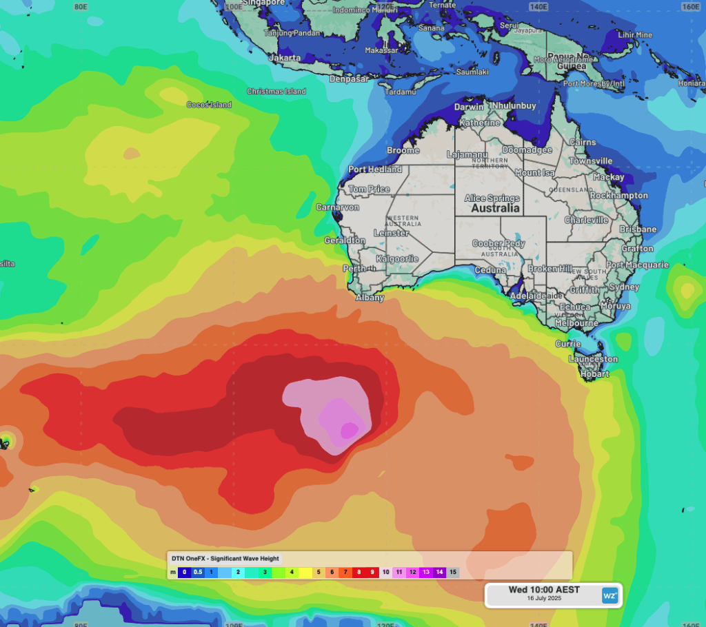
Image: OneFX significant wave heights to the south of Australia at 10am on Wednesday, July 16, 2025.
The swell is propagating across the neighbouring oceans, impacting western and southern Australia with high intensity, before radiating north into the Indian Ocean, Tasman Sea and Pacific Ocean.
Video: OneFX peak wave period radiating out from the storm centre across the Australian region and beyond between Tuesday, July 15, 2025 and Wednesday, July 23, 2025.
Western Australia
Significant wave heights will be largest around the southwest corner, remaining between 5 to 6 metres until early Saturday. A cold front crossing the southwest will bring a pulse of wave heights exceeding 6 metres on Friday morning.
Wave heights of 4 to 5 metres are also expected across parts of the west and south coasts. Wild and woolly weather will mostly dominate under persistent westerly winds. Port and maritime operations should see more favourable conditions over the weekend as the swell eases off.
South Australia, Victoria and Tasmania
Wave heights exceeding 4.5 metres are filling into South Australia, southwest Victoria and western Tasmania this Thursday. The secondary cold front crossing over the region on Saturday should bump up the swell height to around 6 metres, and possibly up to 7 metres for the exposed west coast of Tasmania.
The more northerly wind direction across the coming days will favour a number of South Australia and Victoria’s coasts. For the prime surf breaks of Victoria’s Surf Coast, the westerly swell direction will limit the size reaching into Bells Beach, but favourable conditions should promote a good run of waves.

Image: Bells Beach breaking in a large swell back in May 2023. Source: iStock / FiledIMAGE
The surge of swell on Saturday could limit shipping operations in and out of Adelaide, Melbourne and the Bass Strait with longer period waves reaching 15 to 16 seconds moving into the more sheltered bays and ports.
New South Wales
Australia’s East Coast will see minimal size from this powerful Southern Ocean swell due to the very west direction and distance from the source. Regardless, a very long period south swell (due to the swell refracting around Tasmania into the Tasman Sea) will be felt during Friday.
Possibly as early as the late morning, but most likely in the afternoon, waves from a distant ocean will arrive with periods of 18 to 19 seconds. Even with the limited size of the swell (around 0.2-0.3 metres), every 10-15 minutes surges of wave energy should push into NSW ports.
Indonesia and the South Pacific
While Australia will experience the greatest size and impacts of this swell, the waves will continue propagating across the Indian and Pacific Oceans.
Port and maritime operators across Indonesia may see early signs of the swell on Thursday afternoon as frontrunning waves with extra long periods of 22-24 seconds begin to move into the archipelago. The bulk of the swell will fill in overnight into Friday, with heavy surf extending to Monday next week.

Image: Large waves break off eastern Java’s Grajagan, Indonesia. Source: iStock / Jack Smith
While Australia’s East Coast will mostly miss out on the bulk of this swell, South Pacific islands like Fiji, as well as New Zealand, will see the swell filling in over the weekend, with peak periods reaching into the 20 seconds.
Beyond?
It might not look like it on a map, but on the globe a straight line runs from the Indian Ocean all the way to North America’s west coast. This means our 10-12 metre swell generated southwest of WA can travel unimpeded all the way to California – a journey of about 16,000 kilometres.
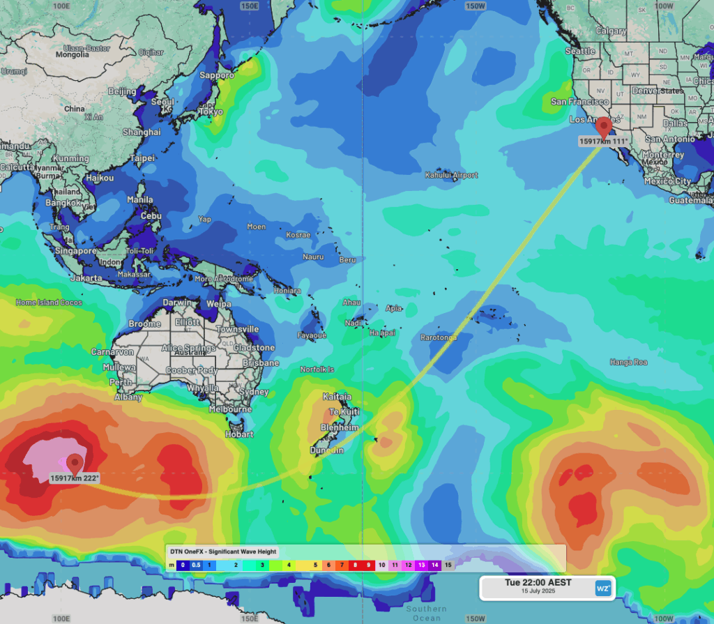
Image: On a globe, this line marks a 16,000 kilometre straight line between the Southern Ocean and the California coast.
Over a week and a half, the swell height will decay to less than 10% its original size – but every 20-30 minutes, a surprisingly powerful set of waves from the other side of the globe will break in in California or Mexico, and it’ll have travelled from south of Australia.
How DTN APAC’s industry leading weather data and alerting minimises risk for offshore, ports and maritime industries
DTN APAC offers a comprehensive suite of services, refined through years of collaboration with the marine, ports and offshore industries, to optimise the safety and efficiency of your operations.
We work with you to understand your intrinsic operational challenges and customise high-precision forecasting, metocean and aviation services to your exact location and operational scope.
When working offshore, our solutions can underpin planning and safe execution for offshore oil and gas enterprises and wind farms. Our data can support your exploration, development, rig moving, shuttle tanker operations, and production and decommissioning phases. Whether your crews are on-site, being transported to shore, or diving to perform maintenance, we deliver tailored weather risk briefings to ensure you choose the optimal time to proceed.
DTN APAC’s trusted nowcasting and forecasting system, OpticastTM, allows you to rapidly respond to changing conditions offshore, en route and in port. We take your port topography and berth orientation into account, ensuring site-specific forecasts. For offshore oil & gas, wind farms, ports and logistics, we have your weather situational awareness covered, no matter where you are. We deliver real-time severe weather and lightning alerts to your team via your integrated dashboard: Portzone, and our Weatherguard app.
DTN APAC’s Total Lightning Network (TLN) ensures you avoid hours of unnecessary downtime by providing the most accurate technology in lightning detection and alerting. Safeguard your teams and assets with lighting and Dangerous Thunderstorm Alerts (DTAs), customised to your existing parameters and delivered in real-time across all devices in your network. You gain full spatial awareness of developing severe weather systems, allowing you to plan ahead and, where needed, execute your shutdown and evacuation procedures.
With extreme conditions slowing production and affecting infrastructure, safety and transport, trust us to deliver Australia’s most precise weather data and tailored insight, giving you decisive confidence when it’s most needed.
Learn more about our large range of industry leading products and services or email us at sales.apac@dtn.com


