The first major cold front of the year is bringing damaging and destructive winds to parts of southeastern Australia as a powerful low moves in from over the Bight.
The satellite loop below shows a deep low pressure system over the Great Australian Bight, and the associated cold front sweeping into South Australia on Monday morning.
Image: satellite loop showing the deep and powerful low and cold front moving into South Australia this morning on Monday, May 26.
A weaker front crossed the southeast over the weekend, bringing wind gusts exceeding 80-90 km/h, with the strongest gusts in each state reaching:
- 119 km/h at Mount William, Victoria, on Sunday evening
- 113 km/h at Neptune Island, SA, on Saturday and Sunday evenings
- 111km/h at Thredbo, NSW, on Saturday evening
- 109 km/h at King Island, Tasmania, on Saturday evening
Steady wind across the Victorian wind farms lead to the highest ever NEM wind generation from Victoria on Saturday evening, with generation peaking at 4,111 MW across the state.
But conditions are getting worse as the most powerful cold front since last year bears down on South Australia this Monday morning.
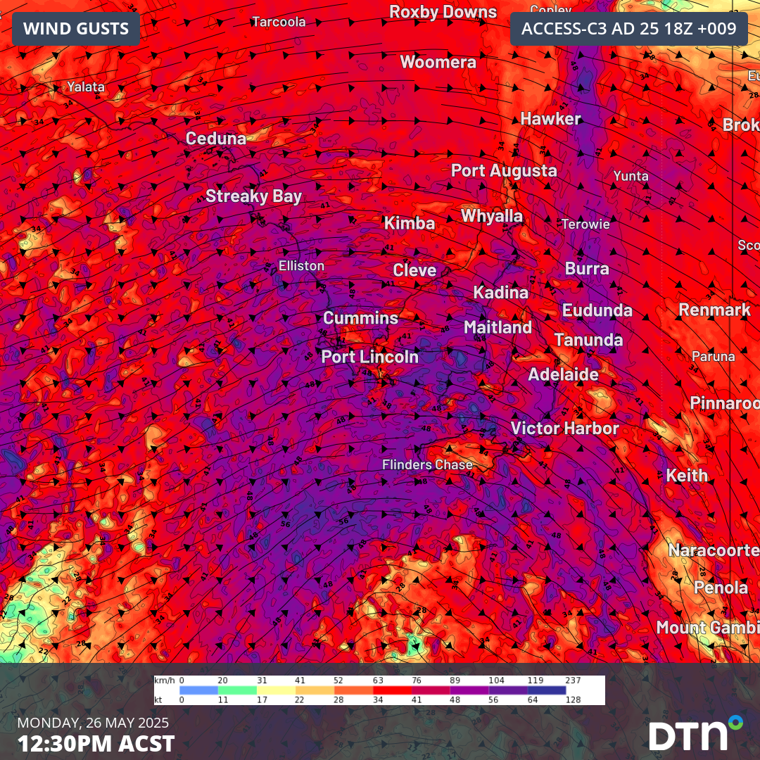
Surface wind speeds of 70-80 km/h are expected from the west to northwest on Monday. However, winds associated with the low and front are exceeding 120-130 km/h just a few hundred metres above the surface. These strong winds aloft will easily mix down to the surface, resulting in wind gusts exceeding 110-120 km/h across coastal and exposed parts of South Australia. As of 9:30am ACST, notable wind gusts recorded on Monday, May 26, include:
- 126 km/h at Neptune Island, SA. The strongest gust since July last year.
- 96 km/h at Cape Borda, SA. The strongest gust since December 2023.
- 89 km/h at Kingscote Ap, SA. The strongest gust since November 2018.
- 122 km/h at Mount William, Victoria. The strongest gust since July last year.
- 104 km/h at Mount Buller, Victoria.

Image: forecast wind gusts across South Australia at 12:30 ASCT on Monday, May 26.
100-110 km/h northwesterly wind gusts will also extend into coastal and elevated parts of Victoria as well on Monday, reaching southern and eastern NSW on Tuesday. Gusty south-to-southwesterly winds behind the front will reach 90 km/h over Tasmania later on Tuesday and Wednesday.
Exceptionally dry soil moisture content across parts of South Australia and western Victoria have resulted from drought conditions over the past 1-2 years. As a result, tree roots across the region are weakened or dead. Combined with the flaky dry grounds surrounding them and lack of powerful cold fronts, the strong winds bring an increased risk of trees and branches falling across transport and power infrastructure. As of 9:30am ACST, South Australia Power Networks was reporting nearly 3,000 customers without power, with more outages to come.
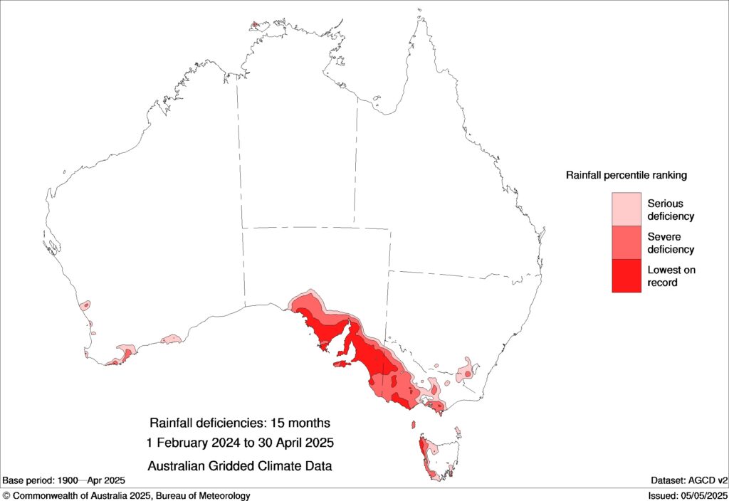
Image: Lowest on record rainfall deficiencies across much of South Australia’s agricultural belt and western Victoria from February 2024 to April 2025. Source: BoM.
While southern Australia is phenomenally dry, the inverse over eastern Australia with recent historical flooding will also bring the risk of trees falling under the strong winds with muddy and loose soil.
Along with the risk of down powerlines and lightning strikes hitting the energy grid, here are seven other ways the strong winds and wild weather over the coming days could lead to power outages over southeastern Australia.
Periods of intense winds can damage wind farm turbines – so propellers are usually stopped when winds reach a ‘cut off’ wind speed of about 90 km/h (25 m/s). As a result, the powerful winds generated by these vigorous cold fronts often go unharnessed by the energy network to maintain the health and operation of the assets.
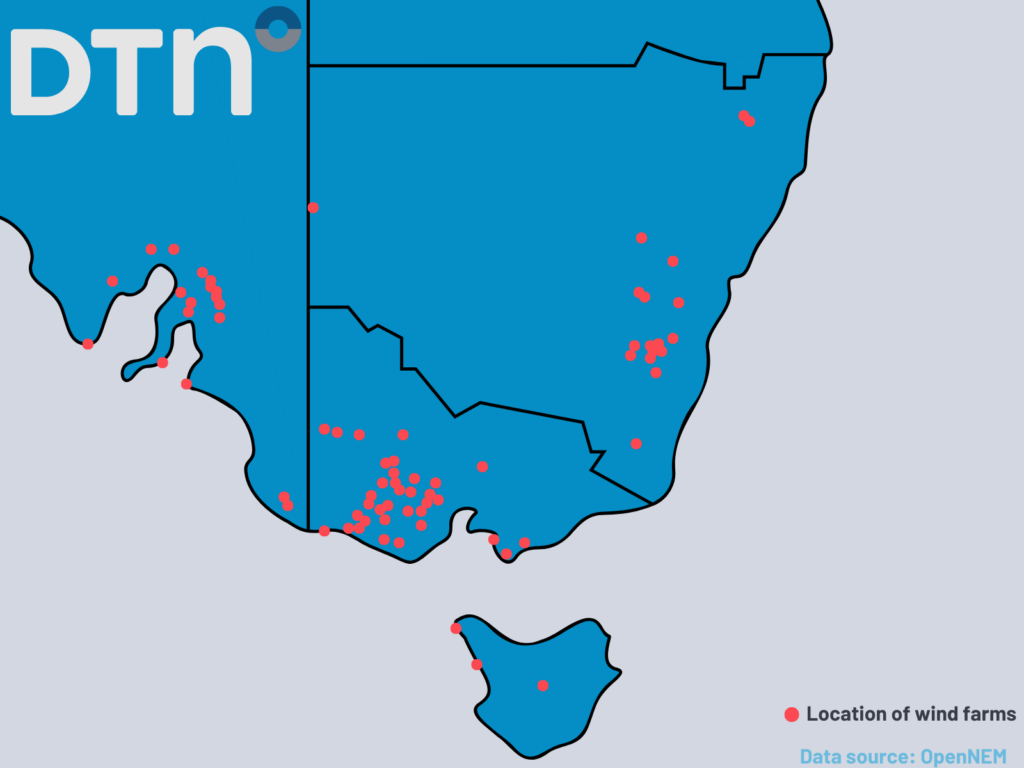
Image: wind farm locations across southeastern Australia.
Unfortunately, chilly conditions across the southeast with a cold airmass and these brisk winds will drive increased energy demand early this week as people look to stay warm.
Conditions will ease as high pressure strengthens over South Australia on Tuesday afternoon, and on Wednesday over Victoria, Tasmania and inland NSW, with gusty winds persisting into early Thursday for coastal NSW as the low moves east into the Tasman Sea.
How DTN APAC services Australia’s wind farms
DTN APAC delivers industry-leading weather and power generation forecasting and real-time alerting to inform your critical decision-making. Together we can keep your staff and assets safe, and efficiency high.
With lightning strikes, severe weather, flood and fire posing risk to wind farms across Australia, we have tailored solutions that can significantly improve your oversight and response.
Total Lightning Network comprises of regional and global sensors to detect intra-cloud (IC) and cloud-to-ground lightning (CG) strikes within your proximity thresholds. It provides unparalled detection accuracy (<200m) and real-time lightning alerts to any device across your operations team.
Your customizable Energyzone interface and Weatherguard app will provide access to the Total Lightning Network as well as centralized data from state and territory fire agencies, the Bureau of Meteorology, and over 30 national and international private and state organisations. This enables full situational awareness of weather conditions and fire risk, as well as severe weather alerting via text, email and phone call, so your staff can respond effectively when required.
Learn more about our large range of industry leading products and services or email us at sales.apac@dtn.com


