It has been a big week for NSW Ports. After a massive band of storms crossed the state on Wednesday, a low off the coast is now generating strong winds, rain and hazardous surf to coastal districts, especially from Sydney to the Qld border.
Numerous warnings are in place, including:
- A severe weather warning for damaging winds and heavy rainfall for the Mid North Coast and parts of the Hunter, Metropolitan, Northern Tablelands and North West Slopes and Plains forecast districts.
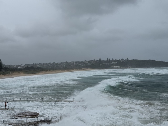
- A warning for damaging surf for Sydney Metropolitan, Hunter, Illawarra & Mid North Coast.
- Multiple warnings for gales and/or strong winds all the way along the NSW coast and extending to the Gold Coast and eastern Victoria.
The low pressure system causing the dangerous weather is currently sitting off the northern NSW coast. While its effects in terms of winds and hazardous surf extend well beyond that region, Friday’s rainfall will be heaviest in the general vicinity of the low in northern NSW.
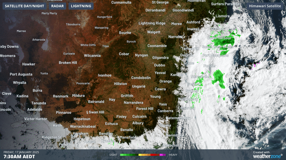
Image: Three-hour radar and satellite loop on Friday morning with swirling clouds indicating the approximate position of the low centred off northern NSW.
Heavy rainfall, possibly leading to flash flooding, is forecast for the northern Hunter and Mid North Coast forecast districts, particularly on Friday afternoon and evening. The BoM estimates that six-hourly rainfall totals between 70mm and 120mm are possible, with the heaviest falls likely on elevated terrain.
For Sydney, rainfall should be less intense than further north, but showers are expected to increase in the afternoon and evening period, meaning there could be weather disruptions to the Big Bash local derby between the Sydney Sixers and the Sydney Thunder at the SCG, starting at 7:15 pm.
Meanwhile dangerously strong wind gusts have already started to lash the Sydney region and parts of southern NSW as we approach lunchtime on Friday.
- 91 km/h gusts were recorded at both Sydney Airport and Kurnell (opposite the airport on the southern shore of Botany Bay) between 10am and 11am.
- Just after 11am, the Bellambi weather station in Wollongong recorded a 98 km/h gust.
- It’s also super windy in southern inland parts of the state – with gusts also topping 90 km/h at Cabramurra in the Snowy Mountains.
On this wild wet and windy Friday in coastal NSW and nearby areas, please check the latest on the Weatherzone warnings page for the latest updates. And for cricket fans seeking the latest info for weather in the vicinity of the SCG, our Sydney page has everything you need.
As demands on ports increase globally, relying on accurate weather data is key to optimising port and logistic operations. DTN APAC, delivers insightful, data-driven forecasts to port operators, allowing harbour masters, vessel transport services and pilotage to make informed, weather-influenced decisions.
DTN APAC users have access to extensive weather data through an integrated dashboard plus the support of experienced, on-call meteorologists. We also deliver a full suite of metocean services, including wave and current modelling, data analysis and consulting. For more information contact us at sales.apac@dtn.com


