Prosper in a dynamic world
Search

Record-warm oceans surrounded Australia in 2024

The Australian region set a new record for ocean temperatures in 2024, with sea surface temperatures close to 0.9°C above the long-term average.

Australia’s annual mean sea surface temperature during 2024 was 0.89°C above the 1961-1990 average. This was the highest annual sea surface temperature on record, beating the previous record anomaly of +0.80°C from 2022.

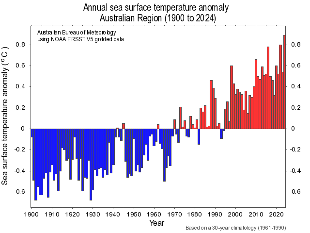
Image: Annual sea surface temperature anomalies in the Australian region between 1900 and 2024. Source: Bureau of Meteorology

January, February, October, November and December all set new records for their respective months. Every other month in 2024 ranked among the top three warmest on record for their respective months, based on data dating back to 1900.

The abnormally warm water surrounding Australia over the last 12 months was part of a larger story of record-breaking global oceanic heat in 2024.

According to data published by the Bureau of Meteorology, Earth’s global average annual sea surface temperature in 2024 was about 0.79°C above the 1960-1990 average. This is also a record, beating 0.74°C from 2023, despite the cooling influence of a La Niña-like pattern, which typically lowers the average global temperature.

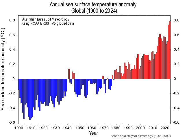
Image: Global annual sea surface temperature anomalies between 1900 and 2024. Source: Bureau of Meteorology

The graphs above reveal a clear warming trend in ocean temperatures. In the Australian region, sea surface temperatures have warmed by around 1.1°C since 1910 and warming has occurred around the entire country.

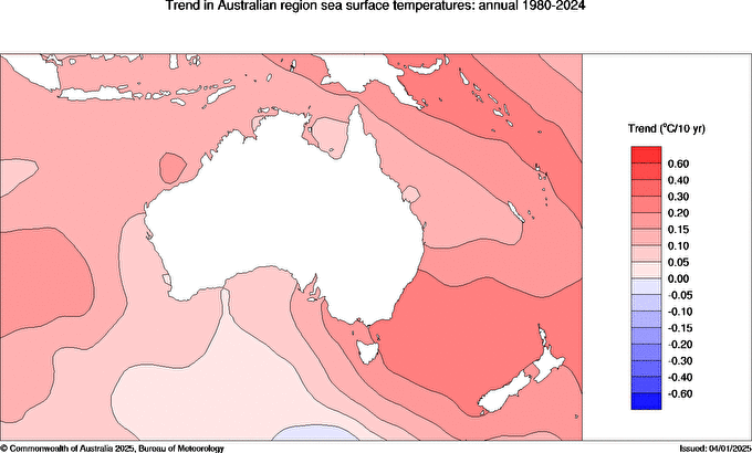
Image: Trend in sea surface temperatures near Australia between 1980 and 2024. Source: Bureau of Meteorology

The warm water surrounding Australia in 2024 was one of the reasons the country registered its second warmest year on record based on air temperature. It also helped make the air over Australia more humid than usual.

To find out more about how these SSTs could impact your business, please visit our website or email us at sales.apac@dtn.com.

Latest news

Satisfy your weather obsession with these news headlines from around the nation, and the world.

El Niño Is Here: What a Potential Record Event Means for Southeast Asia and Australia

  El Niño was officially declared in June 2026, raising the prospect of widespread impacts across Southeast Asia, from extreme heat and water shortages to higher energy demand and agricultural stress.   The World Meteorological Organization has warned countries to “prepare for it to be severe”, while several global forecast models suggest the event could rank among […]

How El Niño will shape Australian port operations in winter-spring 2026

Australian ports and marine pilots can expect a season of shifting wind and swell patterns through winter and spring 2026, as a developing El Niño brings the likelihood of drier conditions and more variable operating windows across the country’s coastline.  Will El Niño develop in 2026?  There are clear signs that an El Niño pattern is becoming […]

From Kimberley to northern NSW: Bushfire outlook flags risk for resources sector this winter

Bushfire risk doesn’t usually make headlines in June, but AFAC’s winter seasonal outlook is putting mining and resources operators on alert from the Kimberley to the NSW.  Australia’s official seasonal bushfire outlook for winter 2026 was released by AFAC on Thursday, May 28. The outlook predicts increased fire risk across the northern parts of the Great Sandy Desert and surrounds […]

The signal was there weeks earlier: forecasting one of the year’s biggest wind events

In mid-May 2026, DTN APAC meteorologists flagged a strengthening Southern Ocean pattern in model guidance, signalling an extended run of record-challenging wind conditions across the NEM.  Nearly three weeks later, NEM wind generation climbed from around 1.5GW to more than 9GW, supplying roughly one-third of the grid and coming within 1GW of the all-time generation record.  The event highlighted […]