A blocking-high pressure system will park itself directly over Tasmania this week, and is forecast to become so strong, it challenges an Australian record.
High pressure is crossing the Great Australian Bight after a cold front swept over southeastern Australia this weekend. While high pressure is common after a cold front, this particular high pressure system will stall, as it becomes a blocking-high over Tasmania from Tuesday morning.
You can see the high pressure system stall over the Apple Isle during the week below, with the centre (marked with a red ‘H’) remaining virtually stationary for nearly 7 days.
Video: Forecast MSLP from ECMWF.
Australia’s high pressure record
The record for the highest Mean Sea Level Pressure (MSLP) could be under threat this week. The all-time Australian record stands at 1044.3 hPa, recorded at Launceston on June 7, 1967.
The ECMWF model shows a forecast central pressure of 1045 hPa is expected on Saturday morning directly over Tasmania, meaning the record could be under threat. Other models show forecast central pressures of around 1042-1044 hPa in close proximity to Tasmania as well.
Due to its position and breadth of the highs’ ridges, it is possible that Melbourne (1041.2 hPa), Canberra (1042.9 hPa), and even Sydney (1040.0 hPa) could also see their pressure records under threat.
Why is this high locked in place?
This high will become a ‘blocking high’, locked in place by the jetstream. The jetstream is a fast-moving belt of westerly winds that circumnavigates the globe in both the northern and southern hemispheres. There are usually 2 jetstreams: one mid-latitude and one polar jet, although they can combine at times.
A ‘blocking-high’ occurs when the jetstream splits around a high pressure centre, locking it in place for days or even weeks at a time. A clear jetsream split can be seen over Australia this week.
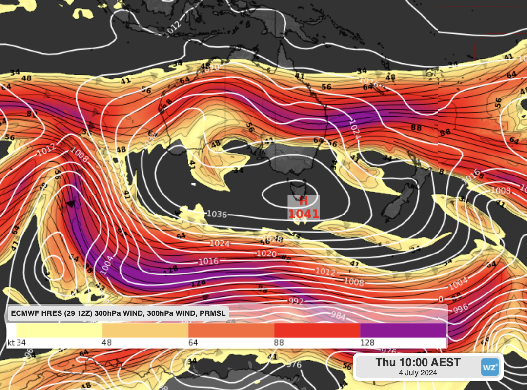
Image: MSLP and the jetstream on Thursday morning. The colours show the positioning of the jets that have split around the high pressure system.
Adding onto this, is the presence of a cut-off low pressure system over South Australia this week. In a process known as ‘anti-cyclonic intensification’ rising air near that low will be transported to the high over Tasmania, where it will slowly start to descend. Since air is much slower sinking than it is at rising, air builds up over the high, increasing its central pressure.
Extended-range forecasts from ECMWF show that Hobart is expected to have a combined weekly pressure anomaly of +22hPa above average. This is well above the 99% percentile mark of +14hPa, indicating it is quite likely to be the highest weekly average pressure for the city.
What weather will this bring across Australia?
High pressure is often associated with clear skies and light winds. So, for most of Tasmania, as well as large parts of Victoria and southern NSW, this high will bring a run of sunny days, but cold frosty nights. Launceston is forecast to fall below zero degrees for the next 7 or 8 mornings in a row.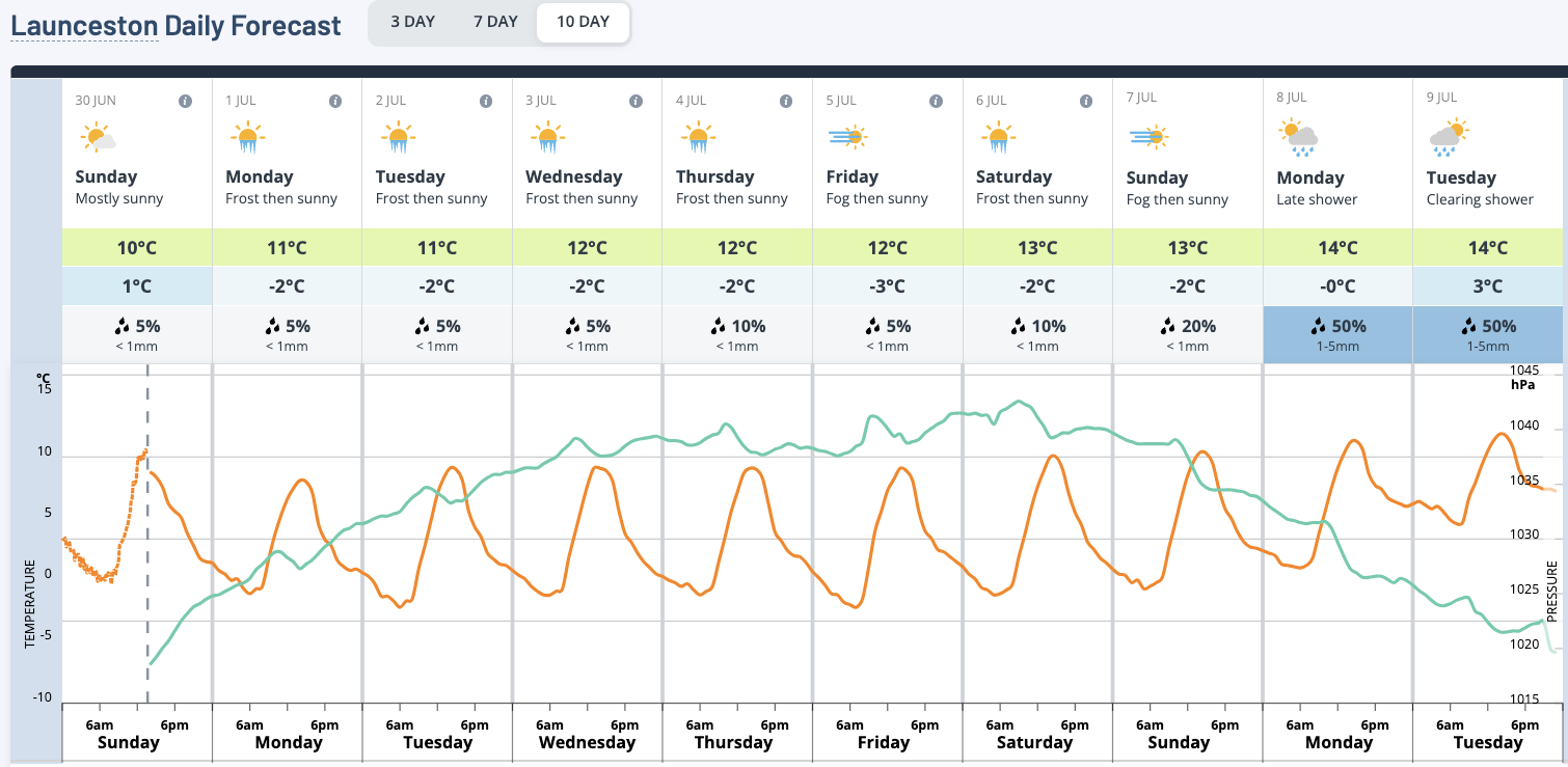
Image: Launceston 10-day forecast. Temperature is in orange (left axis) and MSLP in aqua (right axis).
In Queensland and northern NSW, the high pressure brings persistent southeastly winds to the coast, increasing the chance of showers each day, as well as established ocean swell.
For the remainder of northern Australia, the high to the south will increase winds, leading to warmer days. The increased winds also increase their fire danger, given it is now the start of the northern Australia bushfire season.
For parts of SA and WA, the high means the low pressure systems and cold fronts that are crossing those areas during the week are more likely to bring longer-lasting rain than normal. This is because those types of systems get ‘backed-up’ like being behind a slow car on the freeway, meaning they stick around for longer. SA may also see a rare boost of moisture coming in from Queensland, something that is very unusual to see during the winter months.
Such an intense and focal system is likely to impact weather for nearly every part of the country this week, so stay tuned to the Weatherzone News Feed for updates on all of those weather interactions.
Unfortunately, wind power generation will take a severe hit this week as a result, continuing this winters run of poor generation. Solar energy will increase somewhat, but given that the winter solstice was only last week, generation is typically low at this time of year.
DTN APAC synthesises data from dozens of the worlds leading forecast providers and uses artificial intelligence to provide detailed, local and industry-specific forecasts for your business. To find out more, please explore our website or email us at apac.sales@dtn.com.


