Parts of Western NSW, Qld and Vic have seen double their average May rainfall in the last 24 hours, with rainfall set to continue Friday before focusing on the east on the weekend.
The rain is being generated by an upper level trough which is sitting over the region, which is expected to move east over the weekend.
These are the largest falls recorded during the 24 hours to 9am on Friday, May 10;
- Noona in NSW observed 54mm, taking the monthly total to 89.8mm after 32mm fell during last week’s event.
- White Cliffs saw double the May monthly rainfall average in a day with 44m, the most daily rain in May in 43 years.
- Broken Hill, NSW and Thargomindah, Qld also saw more than a month’s worth of rain, with 23.8mm and 26.2mm falling respectively.
- Mangalore airport, Vic recorded 41.4mm, making it the wettest May day in 24 years.
- Wilcannia, NSW observed 39.8mm, its biggest daily May rainfall in 21 years
The opening nine days of May have been very wet for much of NSW and southeast Qld. Coastal NSW and far southeast Qld have picked up 100 to 200mm during May so far and inland areas of NSW have seen 25 to 100mm fall.
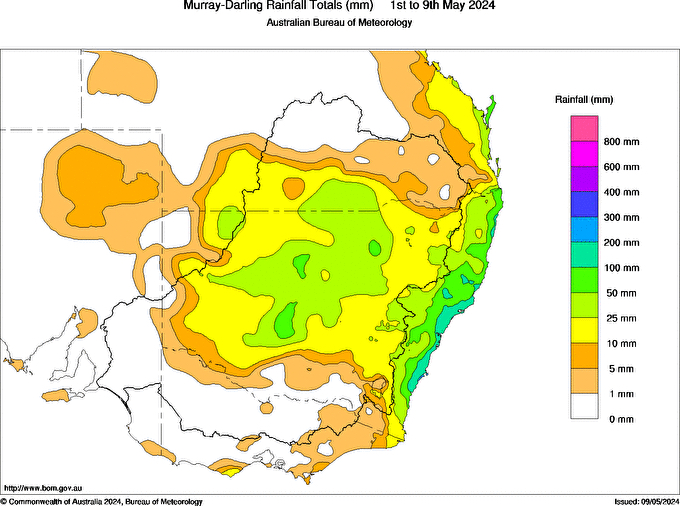
Image: Murray-Darling rainfall totals (mm) between the 1st and 9th of May 2024. Source: Bureau of Meteorology
The map below shows one model’s rain forecast over the next three days, with another round of wet weather forecast for several states and territories in the east. The highest totals and heaviest falls are forecast to occur in the Illawarra and South Coast regions over the weekend.
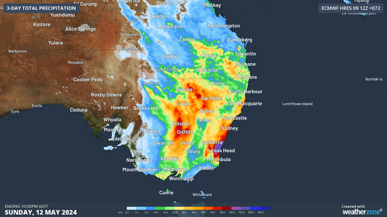
Image: Accumulated rainfall forecast for the 3 days leading up to 10pm AEST on Sunday, May 12, according to ECMWF.
The rain and thunderstorms will continue in south-central Qld, western NSW and north-central Vic on Friday, before shifting east on the weekend with the upper trough.
A low pressure system is expected to develop over the southeast coast on the weekend in response to the upper level trough moving eastward.
While large totals are expected along much of the coastal fringe in NSW and far southeast Qld, the heaviest falls are expected in the South Coast, Illawarra and the eastern Southern Tablelands. Daily rainfall totals of 70 to 100 mm are likely with isolated falls of 150 to 200 mm possible from Saturday into Sunday. The rainfall in these areas could be quite heavy, with six hourly totals of 70 to 90 mm, while some areas could pick up 120mm in six hours.
This rain will be falling on an already sodden landscape after last week’s rainfall, which could increase the risk of flooding.
Looking ahead, the rain should ease during Sunday afternoon as the low moves east into the Tasman Sea. During the middle of next week, there should finally be some sunshine for the east as winds tend to the west ahead of a cold front. Please keep an eye out for the latest severe weather warnings here.
DTN APAC, a DTN company, can assist during severe weather events such as this with our expert insights and daily briefings, helping to reduce the disruptive delays across the network.
We specialise in building customised weather monitoring and alerting solutions. These guide transport operators to plan and respond effectively. We tailor our data and analytics to your exact requirements. The following tools help the transport and rail sector daily.
- Total Lightning Network- Precise lightning detection which pinpoints where your personnel need to prepare and respond.
- Stormtracker- visualise adverse weather conditions impacting your network, with multiple weather and alert layers which animate over your infrastructure.
- Nowcasting, forecasting and severe weather alerting services to help coordinate your team, limiting downtime and scheduling maintenance in optimal weather windows.
We provide customised weather intelligence to keep your transport business moving, for more information, please contact us at apac.sales@dtn.com.


