
After a prolonged period of light winds, a surge of powerful winds and cool air will push through southeastern Australia during the next 48 hours.
As we wrote about last week the National Electricity Market (NEM) saw very low wind power generation during the seven days leading up to Thursday, April 18, with the daily wind generation having been under 41 GWh/day for this period.
Wind power has improved slightly during the past week, with wind power increasing for a few days over last weekend. The chart below shows that the winds across the NEM have already increased in response to a cold front approaching SA and Vic on Tuesday.
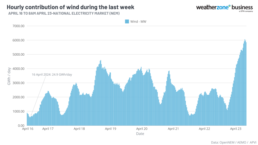
The increase in wind power is associated with a cold front sweeping across southeastern Australia, after a stubborn high-pressure system forced many cold fronts south for over a week.
The map below shows the cold front marching across the Bight, approaching SA on Tuesday morning. You can also see a broad area of speckled cloud in the Bight, which is a tell-tale sign that a large mass of cold polar air has broken away from the Antarctic region and is venturing into the relatively warm mid-latitudes.
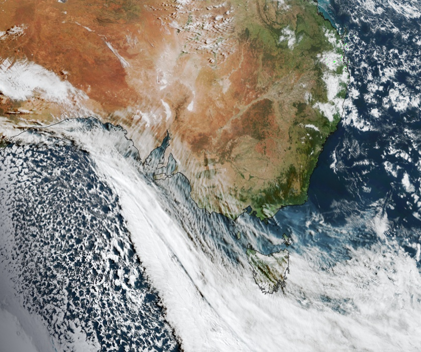
Image: Himawari-9 satellite image at 9:30am AEST on Tuesday, April 23.
Northwesterly winds will continue to strengthen ahead of the cold front on Tuesday in SA and Vic before a strong southwesterly change hits Adelaide on Tuesday afternoon and Melbourne in the evening.
The images below show the wind gust forecast for Tuesday and Wednesday afternoon.
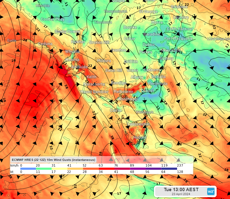
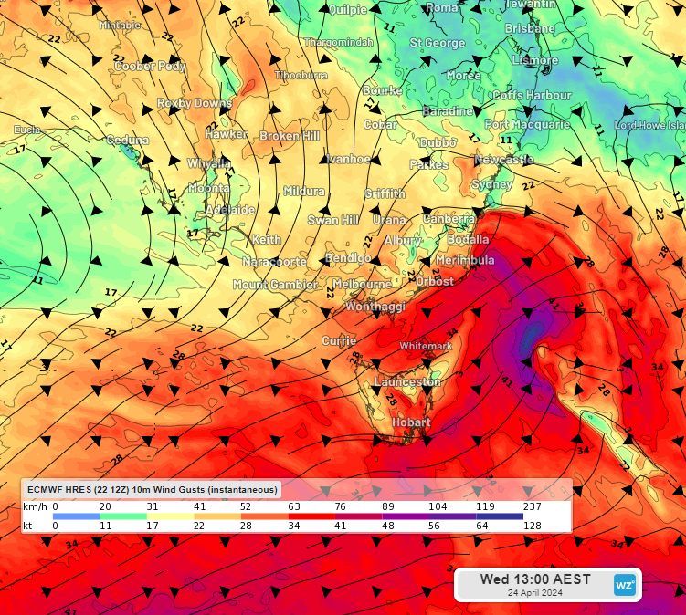
Image: Instantaneous wind gust forecast at 1pm AEST on Tuesday (top) (bottom)and Wednesday, April 23 and 24, according to ECMWF
While most of this wind should hit the wind power ‘sweet spot’, cut outs could occur at southeastern Vic and southern NSW wind farms late Tuesday into Wednesday. Generally, cut outs occur when wind speeds exceed 90km/h (25 m/s), which is when the wind turbines are turned off to prevent damage.
In the image above you can see the front and associated southerly change moving up the NSW coast on Wednesday, hitting Sydney on Wednesday afternoon.
Winds will then become light later this week as another high-pressure system moves into the Bight.
Cool change coming
Ahead of this change, much of southeastern Australia has experienced pleasant autumnal weather, with Sydney’s temperature for the next two days reaching 27°C. However, there will be a large temperature contrast ahead and behind the cold front in the next few days. The image below shows forecast air temperatures around 1.5km above sea level on Wednesday morning, showing the cool airmass moving over parts of SA, VIC, Tas.
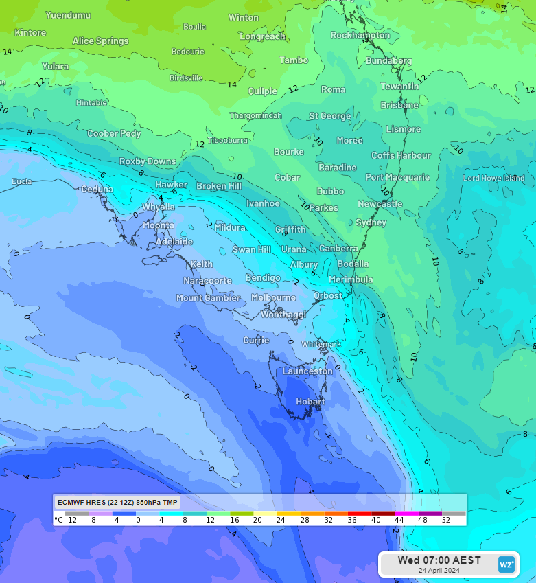
Behind the cold front strong southwesterly winds will cause temperatures to plummet to around 2-3°C below average across southern Australia;
- Melbourne and Adelaide’s temperature dropping to around 16-18°C for several days following the front.
- Hobart’s temperature will drop from 22°C on Tuesday to 15°C on Wednesday.
- Sydney’s temperature will go from 5°C above average on Wednesday to average on Thursday.
The coolest air will move over Tas, bringing snow to the alpine region there.
Looking ahead, temperatures will recover later this week ahead of another cold front and burst of wind power early next week.
DTN APAC delivers industry-leading weather and power generation forecasting and real-time alerting to inform your critical decision-making. Together we can keep your staff and assets safe, and efficiency high.
With lightning strikes, severe weather, flood and fire posing risk to wind farms across Australia, we have tailored solutions that can significantly improve your oversight and response.
Total Lightning Network comprises of regional and global sensors to detect intra-cloud (IC) and cloud-to-ground lightning (CG) strikes within your proximity thresholds. It provides unparalled detection accuracy (<200m) and real-time lightning alerts to any device across your operations team.
Your customizable Energyzone interface and Weatherguard app will provide access to the Total Lightning Network as well as centralized data from state and territory fire agencies, the Bureau of Meteorology, and over 30 national and international private and state organisations. This enables full situational awareness of weather conditions and fire risk, as well as severe weather alerting via text, email and phone call, so your staff can respond effectively when required. For more information, please contact us at apac.sales@dtn.com.


