Prosper in a dynamic world
Search

Sydney to soar to 40 on last day of summer

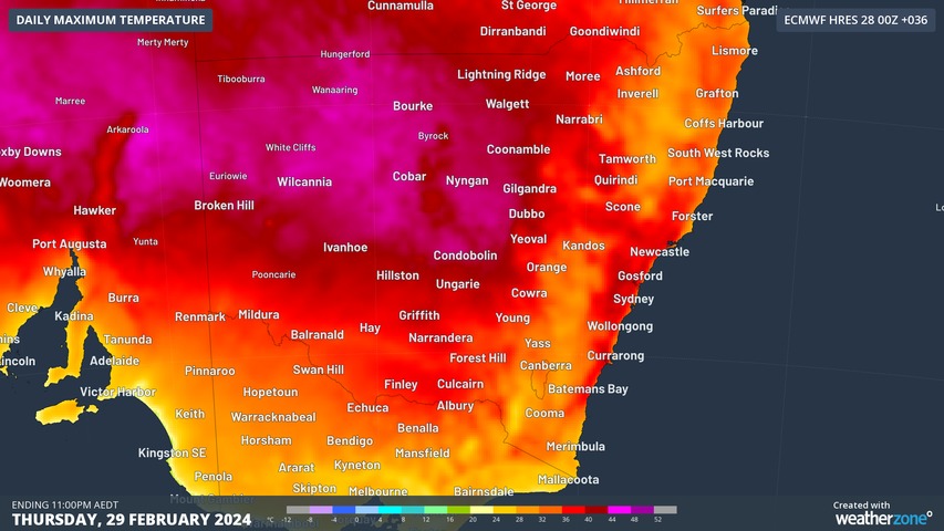
Sydney is set to soar to 40 on the last day of summer, with parts of the city’s west likely to reach 39°C or 40°C, while the city should reach 35°C before a late cool change arrives.

On Wednesday, temperatures topped 43°C in several spots in the Mallee region in Victoria’s northwest, while temps reached 44°C in at least two locations in far western New South Wales.

That heat has been tracking across southern Australia from west to east for several days, and it will finally reach the east coast on Thursday, with only Sydney’s coastal suburbs spared the worst of the heat.

Canberra is also in for a reasonably hot one with a top of 34°C expected, which will make Thursday one of the sweatiest days of the 2023/24 summer.

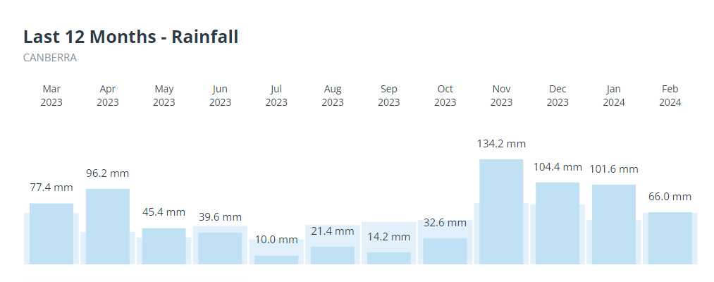
The national capital hasn’t had a particularly warm summer by its standards, with a hottest day to date of 34.8°C on December 9. Rain tends to keep a lid on extreme daytime temperatures, and as you can see on the graph below, Canberra has indeed had a wet summer.
As of Wednesday evening, the bushfire danger for Thursday is currently rated as high in about half of New South Wales, but it will pay to keep checking the latest info at the Rural Fire Service website.

Your business can benefit from the timely delivery of accurate weather information, allowing informed and effective decision-making. For more information, please contact us at apac.sales@dtn.com.

Latest news

Satisfy your weather obsession with these news headlines from around the nation, and the world.

Southern Hemisphere’s polar vortex is weakening – here’s what this means for Australian weather

Stratospheric warming high above Antarctica could cause the Southern Hemisphere’s polar vortex to weaken at an unusually fast pace over the coming weeks. This weakened polar vortex has the potential to affect weather patterns across Australia and other parts of the Southern Hemisphere. What is the polar vortex? The polar vortex is a large circulating […]

Severe thunderstorms, tornadoes and flooding rainfall lash out over NSW businesses and industries

Severe thunderstorms, tornadoes and flooding rainfall have disrupted transport, rail, aviation and many other industries across NSW as a low pressure system tracked over the state. Severe thunderstorms and tornadoes in western NSW A tornado was observed near the town of Young on the South West Slopes of New South Wales around 3:30pm on Wednesday […]

Wild night of rain, wind and surf coming for Sydney and surrounds disrupting port, transport and energy utility industries

Intense and disruptive thunderstorms, rain, strong winds and large surf will develop along eastern NSW later today, bringing localised areas of flooding and hazardous driving conditions. A cut-off low currently tracking over western NSW, is bringing heavy rain and thunderstorms to the region. This burst of early spring storms already marks the wettest September day […]

Widespread thunderstorms captured by DTN’s Oracle and TLN across remote Australian mining areas

Intense and severe thunderstorms across remote and hard to reach mining areas of Australia – typically outside of traditional radar coverage, were detected by DTN’s vast network of remote sensing products. Numerous outback locations in three states and the Northern Territory saw thunderstorms with heavy rainfall from Monday afternoon through to Tuesday morning. Notable 24-hour […]