An unprecedented May deluge has impacted businesses across eastern NSW this week, with some rain gauges eclipsing their previous monthly records in the space of just three days. So why is eastern NSW seeing so much rain this week?
In an average May, the NSW Mid North Coast and Hunter regions would see about 50 to 150 mm of rain. This week, some places have copped more than 500 mm in just three days and more than 300 mm in 24 hours.
The rain has been so intense these past few days that a few places even managed to beat their previous May monthly records within 72 hours.
Mount Seaview’s 614.2 mm during the 72 hours ending at 9am on Thursday was more than four times the site’s May monthly average. This three-day deluge also beat its previous May monthly record of 558.2 mm from 1980, with data available back to 1949.
More than 10 rain gauges in eastern NSW received more than 500 mm (half a metre) of rain between Monday morning and Thursday morning, including Taree Airport, Mount Barrington, Mooral Creek, Comboyne Public School and Mount Seaview. This is also Taree’s first May to eclipse 500 mm, with data stretching back to 1882.
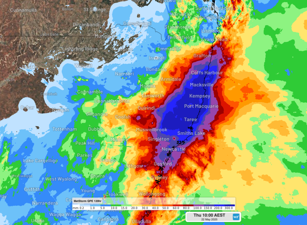
Image: DTN MetStorm QPE showing estimated observed rainfall over eastern NSW during the 120 hours ending at 10am AEST on Thursday, May 22, 2025. Source: Weatherzone / DTN
This week’s injection of water onto an already damp landscape has resulted in deadly and record-breaking flooding.
Tragically, a man’s body was found in a flood-impacted home on the lower Mid North Coast on Wednesday.
As of 10am AEST on Thursday, major flooding was impacting the Manning, Paterson, Hastings and Macleay Rivers. Numerous moderate to minor flood warnings are also in place in eastern NSW, extending from the Northern Rivers to west of Sydney.
Why has there been so much rain this week?
The main drivers behind this week’s heavy rainfall over eastern NSW were a near-stationary low pressure trough interacting with a stagnant pool of cold upper-level air and a relentless stream of moisture-laden winds.
However, there were a several unique characteristics about this weather event that resulted in colossal rainfall and devastating flooding:
- A broad pool of cold upper-level air has been lingering over NSW since the start of this week. This cold air aloft provided what meteorologists refer to as upper-level forcing, which deepened a low pressure trough near the surface and enhanced convection (clouds forming in rising air) over eastern NSW.
- The low pressure trough hardly moved over the space of four days, which caused heavy rain to remain focussed on the Hunter and Mid North Coast regions for a prolonged period.
- The onshore winds feeding the rain this week have extended through a deep layer of the atmosphere, which provided copious fuel for rain-bearing clouds.
- Above average sea surface temperatures in the Tasman Sea provided extra atmospheric moisture, increasing how much water was in the sky to fall as rain.
- The landscape across eastern NSW was already wet before this week’s rain arrived, which exacerbated the extent and severity of flooding.
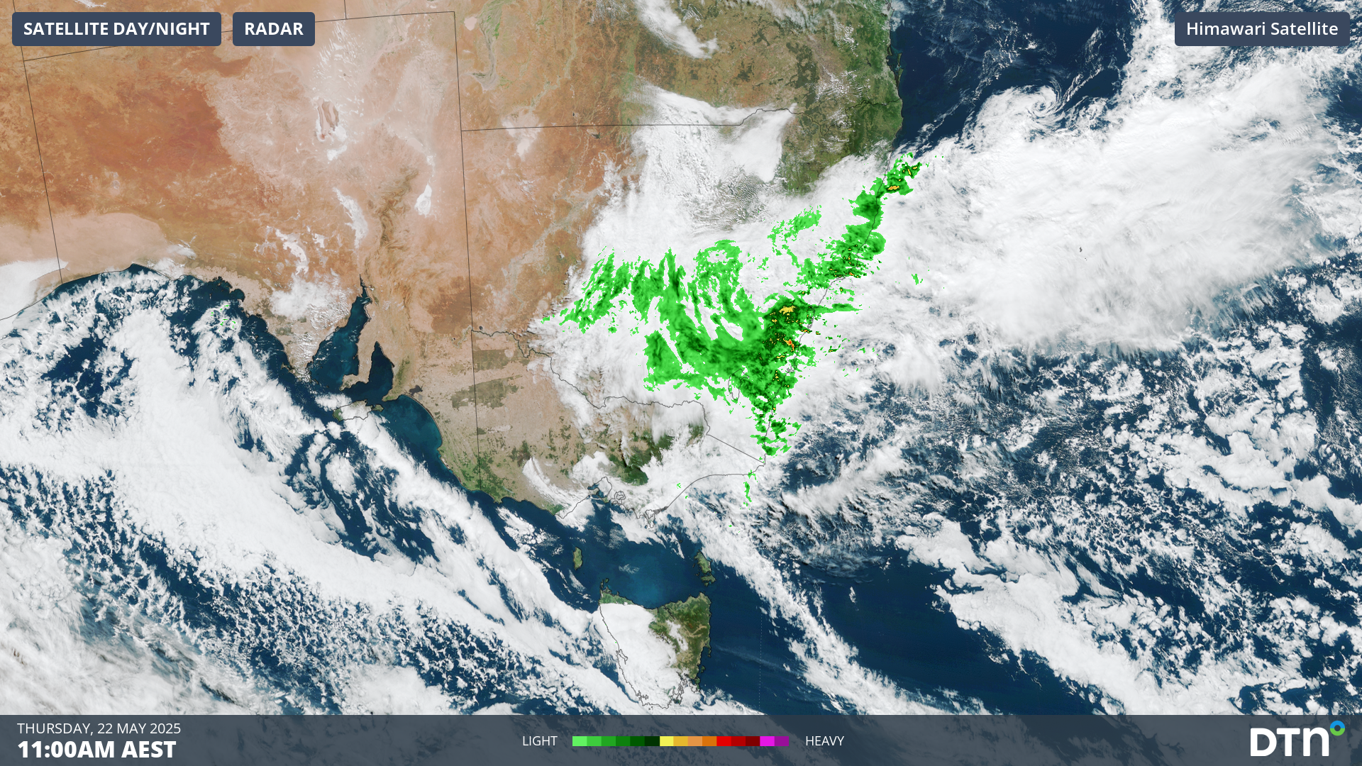
Image: Composite radar and satellite imagery showing cloud and rain streaming over NSW on Thursday morning.
When will the rain stop?
Rain will continue over flood-affected areas of eastern NSW on Thursday and has also become more widespread across the state. The wet weather will gradually contract towards southern NSW on Friday and clear from the state on Saturday.
The Mid North Coast and adjacent Northern Tablelands and Hunter regions could see another 50 to 100 mm of rain on Thursday, with isolated falls of 100 to 200 mm. This rain should ease into Friday morning, although flooding is likely to linger beyond the end of this week.
Further south, accumulated rainfall totals of 30 to 80 mm are likely over a broad area of eastern and southern NSW between Thursday and Friday. Some areas of the state’s central ranges could see about 60 to 130 mm over Thursday and Friday combined.
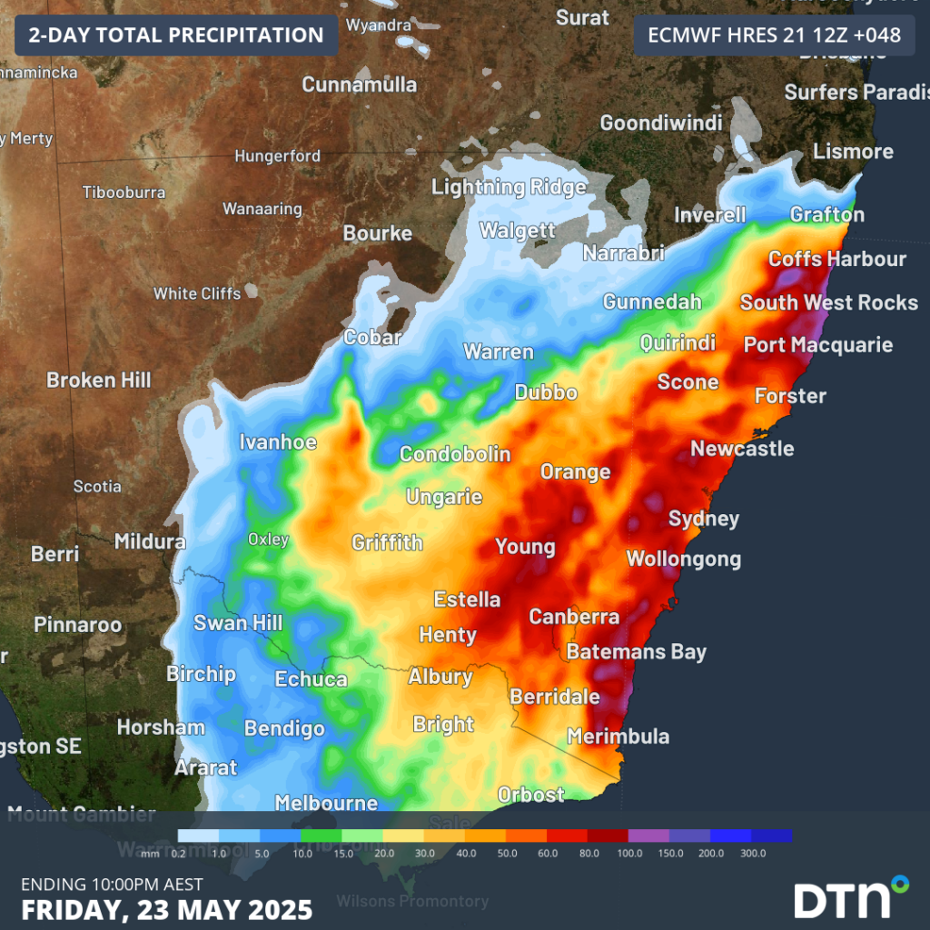
Image: Forecast accumulated rain during the 48 hours ending at 10pm AEST on Friday, May 23, 2025.
Numerous roads, rails, schools and businesses are closed across eastern NSW in response to this week’s rain and flooding. Be sure to check the latest warnings and road closures in your area and remember to never drive through floodwater.
How DTN APAC serves the emergency services
Working in severe conditions in the high-risk fields of emergency, our consolidated weather services can ensure full situational awareness for you and your team.
DTN APAC serves the forestry and emergency sectors, delivering trusted weather data and severe weather alerting to maintain safety, protect your assets and underpin your planning.
DTN APAC’s trusted nowcasting and forecasting system, OpticastTM, is independently proven to outperform other industry models, allowing you to respond rapidly to changing conditions. Opticast can ingest data from your on-site weather observation equipment, ensuring your forecast is customised to your local microclimate. From nowcasting and 14 day forecasting to seasonal outlooks, you have powerful, hyper-local weather alerting and intelligence, giving you decisive confidence when it’s most needed.
With lightning a prominent cause of forest fires throughout Australia, DTN APAC’s Total Lightning Network offers real-time detection and unsurpassed accuracy of lightning strikes to <200m. Based on a vast sensor network, both intra-cloud and cloud-to-ground strikes are located, ensuring you are alerted when severe weather is building and threatening your teams, assets and infrastructure. When volatile conditions increase the ferocity of fire it’s imperative you have lead-time to enact safety plans, keeping your people out of harm’s way.
DTN APAC delivers the Flood Risk System (FRS) to provide flood risk visibility. You can now easily visualise precipitation, and access rapid-update forecasting, across multiple sections of your site with the FRS geofenced alerting system. Gain a more precise determination with DTN APAC’s advanced geospatial technology creating hundreds of virtual ‘weather stations’ for each monitored section or culvert.
Rainfall is measured across each of your established catchments, with alerting calibrated to their individual thresholds. Alerts are raised when thresholds for any section are approaching or have been breached. This gives you targeted risk visibility to inform your assessment, operational response and emergency management.
Your weather intelligence is accessible across all devices in your network via our Weatherguard App, and your customisable interface, so you can provide your team with the most up-to-date information on whether conditions will ease, continue, or worsen.
We are there for you when you need us the most – 24/7, 365 days a year.
Learn more about our large range of industry leading products and services or email us at sales.apac@dtn.com


