While southeast Qld is bracing for dangerous weather from Tropical Cyclone Alfred, heavy rain that may cause flooding in the coming days will likely impact transport operations in the coming days across NSW.
The video below shows Alfred crossing the coast near or to the south of Brisbane and rapidly weakening over land to a tropical low as it moves west. The model suggests that the then Ex-Tropical Cyclone Alfred will move southeast towards the South Coast of NSW.
Video: Mean Sea Level Pressure and 6-hour rainfall between Wednesday, March 5 and Monday, March 10, according to ECMWF
Alfred could cause a phenomenon called the black nor’easters, which can bring heavy rainfall along the east coast of Australia. They typically cause a build-up of thick dark clouds, turning the daytime black (hence the name), that result in heavy rain and sometimes powerful northeasterly winds along the east coast of Australia.
The image below shows that strong northeasterly winds are forecast around 1.5km above the surface across the central and southern coasts and ranges on Sunday morning.
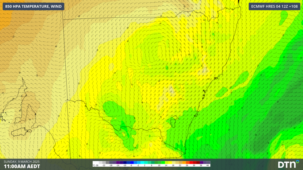
Image: 850 hPa wind and temperature at 11am AEDT on Sunday, March 9, according to ECMWF
The strong northeasterly winds will drag in abundant moisture from the unusually warm seas off the NSW coast which increases the risk of large rainfall accumulations and heavy rainfall in the region.
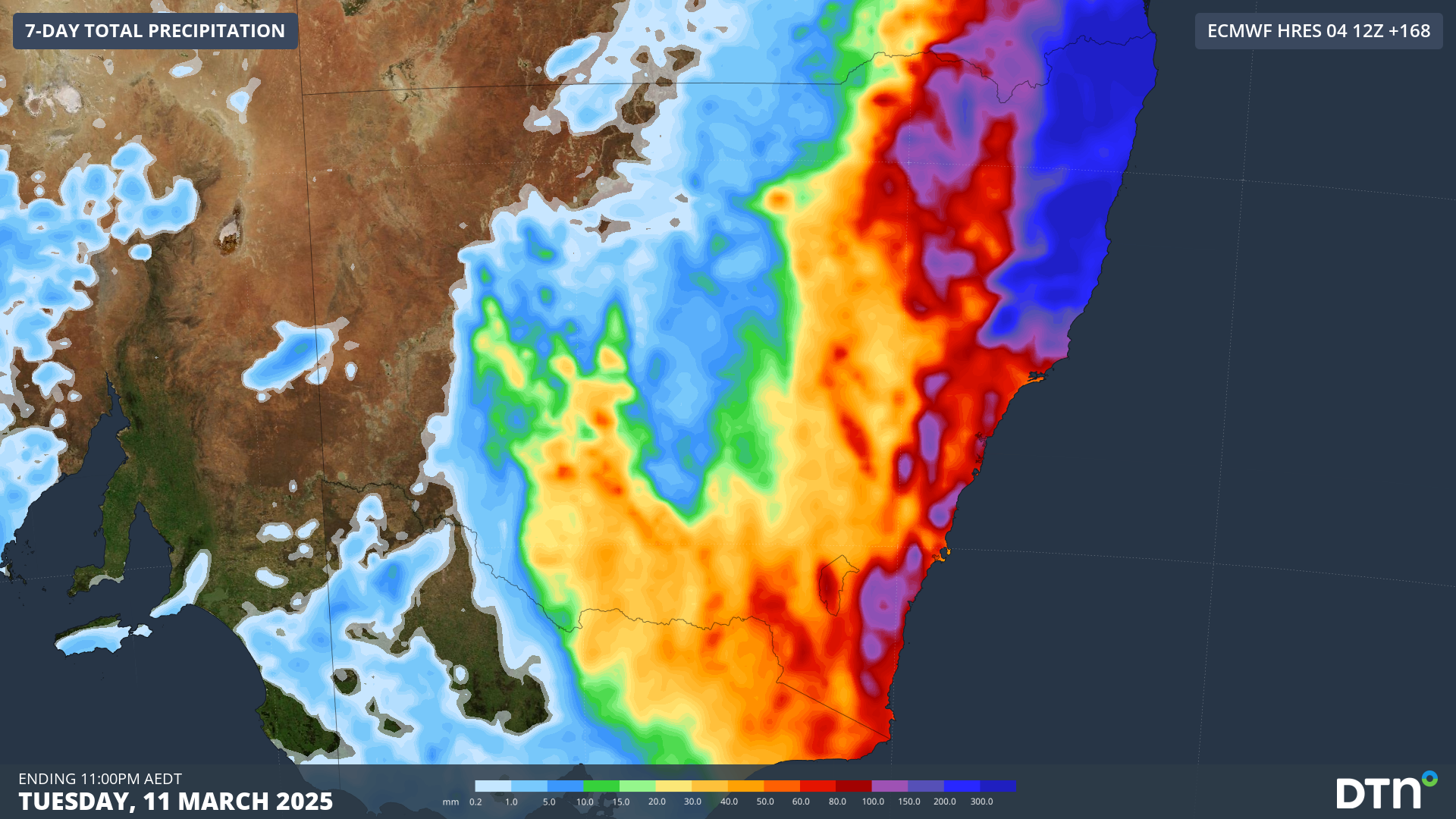
The map below shows that northeast NSW are forecast to see falls of 300mm or more in the next week, however elevated locations close to the coast could see 600 to 1000mm of rain.
You can also see that the model is suggesting 100mm could fall across pockets of central and southern NSW in the coming week, as Alfred moves towards the south coast. With abundant moisture available in the black nor’easters, these areas, including Sydney and the Illawarra, may see higher rainfall than models show, potentially closer to 80-150mm.
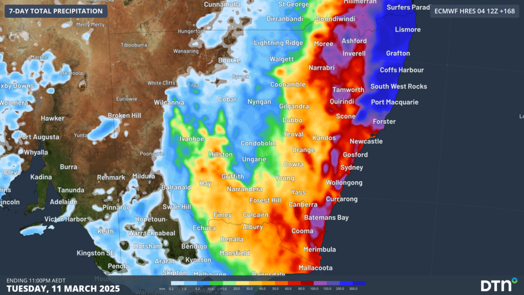
Image: Accumulated 7-day rainfall to 11pm AEDT on Tuesday, March 11, according to ECMWF
Scattered to widespread thunderstorms on Sunday and Monday should increase the likelihood of heavy rainfall that could lead to flash flooding in some areas.
There is still a lot of uncertainty regarding Tropical Cyclone Alfred’s extended track and the amount of rainfall that could fall in NSW over the coming week and our Risk Communications Meteorologists have been regularly updating our clients on the risks to their businesses.
DTN APAC, specialises in building tailored weather monitoring and alerting solutions. These provide heightened visibility, guiding you to plan and respond effectively when adverse weather threatens transport operations. Our weather insights, including flood and fire proximity alerts, warn you of potential and real-time hazardous weather affecting water, rail and road conditions.
Your control interface delivers centralised services, password protected for your personnel. It’s purpose-built to meet your unique specifications, delivering easy-to-visualise critical intelligence that is scalable. Industry-leading lightning detection, GIS storm tracking, nowcasting, forecasting and severe conditions alerting are the foundation of the weather API. You then have the option to layer additional premium solutions to meet your unique requirements.
Leverage our comprehensive weather data to inform your route planning, minimise delays where possible, and mitigate the disruptive effects of severe weather events. To find out more about large range of products and services contact us at sales.apac@dtn.com


