Flood records are being broken in parts of eastern NSW this week as relentless rainfall continues to dump water into already overflowing rivers and creeks, affecting businesses and industries through road and transport closures and disruptions due to flooding.
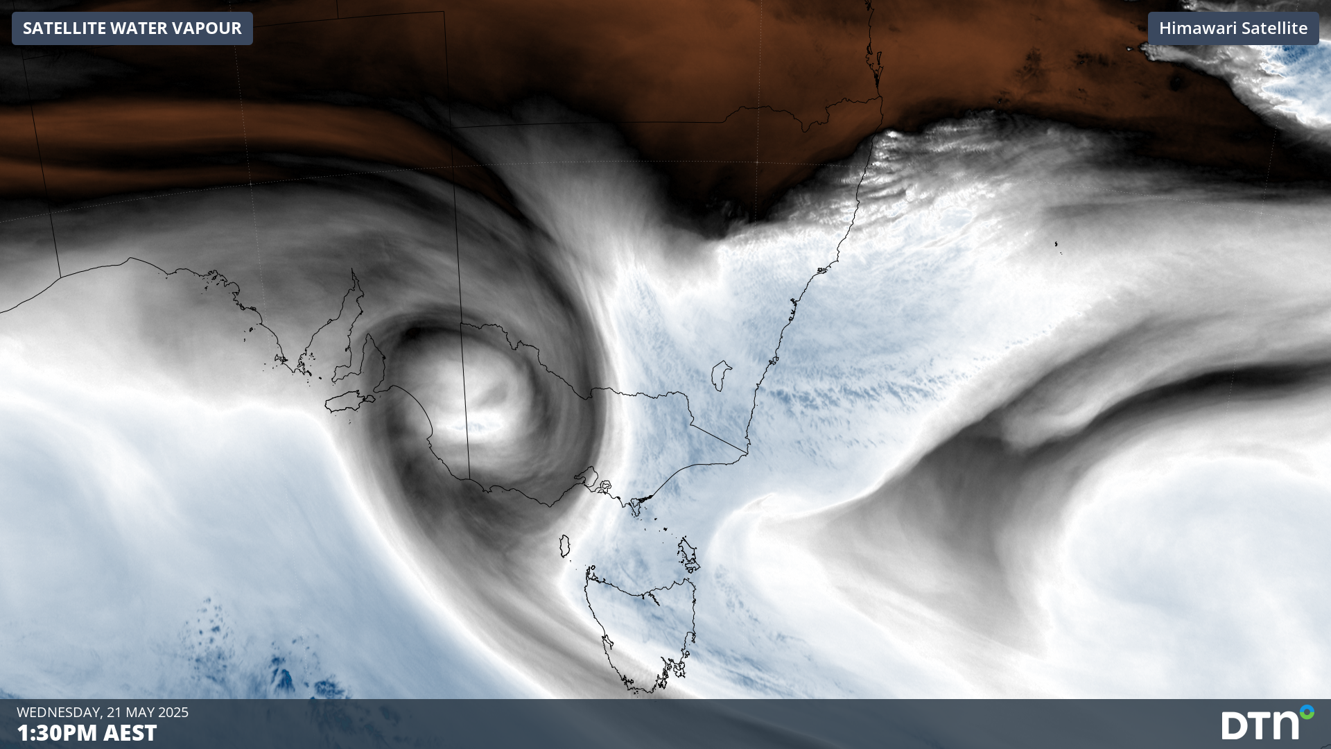
A steady stream of moisture-laden onshore winds has been causing persistent rain over eastern NSW since Sunday. This three-day soaking has been enhanced by a slow-moving low pressure trough near the surface and a pool of cold upper-level air, resulting in localised heavy falls.
Video: Radar animation showing rain streaming over eastern NSW between Sunday and Tuesday.
Some areas of eastern NSW received more than 400 mm of rain in the 48 hours ending at 9am AEST on Wednesday, including:
- 449 mm at Mooral Creek
- 436 mm at Moppy Lookout
- 430 mm at Mount Seaview, including 319 mm in 24 hours and 118 mm in 6 hours
- 427 mm at Careys Peak
- 425 mm at Mount Barrington
- 412 mm at Comboyne Public School
- 416 mm at Taree Airport, equivalent to 4-5 months’ rain at this time of year
Major flooding hits record levels
The heavy rain from the past few days has resulted in major flooding across several river systems in the Hunter and Mid North Coast, including the Paterson, Gloucester, Manning and Hastings Rivers.
The river height of Manning River at Taree climbed above 6 m shortly after 1am AEST on Wednesday and had reached 6.39 m by 11am. This is a new record for this site, beating 5.97 m from 1929. A flood of this magnitude is exceptionally rare at Taree, having less than a 0.2% probability of occurring in any given year, meaning it is rarer than a 1-in-500 year flood event.
More rain to come
Despite already enduring several days of unrelenting wet weather, large areas of NSW will continue to see rain in the next few days.
Persistent rain with locally heavy falls will continue to soak the Mid North Coast and Northern Rivers and the adjacent tablelands on Wednesday and Thursday, before finally clearing from Friday.
Rain will also spread further south and west across other areas of NSW from Wednesday night into Thursday, before contracting towards southern NSW on Friday and clearing on Saturday.
The map below shows the forecast accumulated rain between Wednesday and Friday.
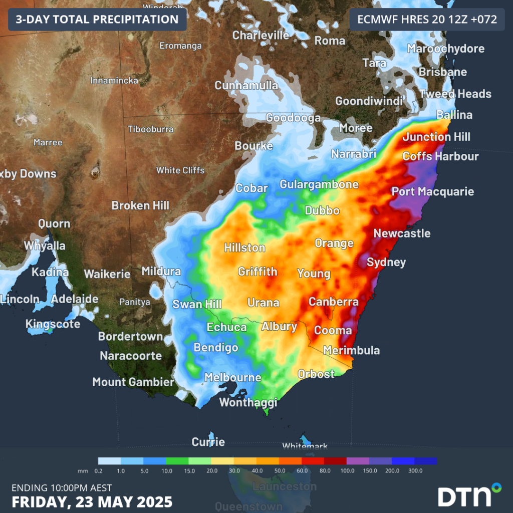
Image: Forecast accumulated rain during the 72 hours ending at 10pm AEST on Friday, May 23.
The magenta areas on the map above represent areas that could see more than 100mm over the next three days, although localised totals of around 200-300 mm are possible in the Mid North Coast.
The upcoming rain will be falling into already saturated river catchments, so flooding is a high risk. Be sure to check the latest flood warnings, weather warnings and road closures in your area over the next few days.
How DTN APAC can help
We help businesses in Australia and Asia Pacific prepare for severe weather and storms, across sectors including Roads and Transportation, Emergency Services, Mining, Insurance and Energy.
The DTN APAC Flood Risk System (FRS)
DTN APAC, delivers the Flood Risk System (FRS) to provide flood risk visibility. You can now easily visualise precipitation, and access rapid-update forecasting, across multiple sections of your site with the FRS geofenced alerting system. Gain a more precise determination with DTN APAC’s advanced geospatial technology creating hundreds of virtual ‘weather stations’ for each monitored section or culvert.
Rainfall is measured across each of your established catchments, with alerting calibrated to their individual thresholds. Alerts are raised when thresholds for any section are approaching or have been breached. This gives you targeted risk visibility to inform your assessment, operational response and emergency management.
The FRS can be integrated into your existing DTN APAC interface, or your own monitoring and control systems. Real-time monitoring of each catchment’s predefined thresholds is coupled with forecasting of rain, so you can provide your team with the most up-to-date information on whether conditions will ease, continue, or worsen.
DTN APAC’s risk communicators
The shifting climate is creating increasingly complex extreme weather risks, affecting businesses worldwide. We are here to help optimise your resilience.
Our Risk Communicators work closely with you to analyse how weather impacts your operations and communicate potential risks. We can then support your risk management planning, and provide situational awareness and post-event reporting when extreme weather events hit hard.
DTN APAC, is a diverse team, with global forecasting, product development and analytics expertise. Couple this with extensive industry experience spanning Aviation to Energy, and we are primed to assist you in strengthening your operational strategies when responding to weather disruption.
We consult with you to understand the nuances of your operations and your existing procedures and policies. We can then assist in creating communication structures, safety strategies and procedures to mitigate the risks that may impact your workforce, assets and uptime.
Rely on our insights to see you through complex situations, maximizing the safety of your staff and assets, and your uptime where possible.
DTN APAC’s Stormtracker
Embedded in DTN APAC’s industry interfaces, the system gives you a time advantage when monitoring conditions developing over your infrastructure and location.
Stormtracker is our Global Information System (GIS) tracking tool, providing multiple weather layers and zoom controls overlaid on a map of your location and infrastructure. You can choose a snapshot or full screen view, depending on your requirements. The maps allow you to monitor all weather, and specifically any systems likely to cause risk for your business. You also have the capacity to observe real time lightning and thunderstorm alerts, and official warnings for storm, wind and floods.
Stormtracker’s radar imagery updates every 10 minutes, so you are always able to respond rapidly to changing conditions. You can customise alerting to notify you when your staff or infrastructure are under threat. With increased situational awareness, your ability to make informed decisions quickly is optimised.
Learn more about our large range of industry leading products and services or email us at sales.apac@dtn.com


