A severe tropical cyclone could hit eastern Queensland later this week, bringing a risk of heavy rain, flooding, destructive winds and a dangerous storm tide.
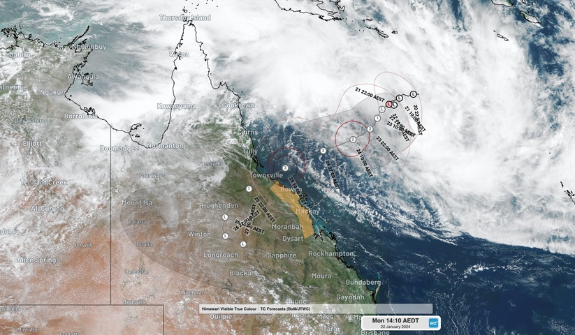
At 10am AEST on Monday, January 22, a tropical low was located over the central Coral Sea, roughly 860 km to the east northeast of Townsville.
Image: Visible true-colour satellite images of the Coral Sea tropical low on Monday.
The low is likely to track towards the southwest over the next few days, likely gaining strength as it draws energy from the warm surface water of the Coral Sea.
The tropical low is expected to become a tropical cyclone on Monday or Tuesday morning, to be named Kirrily, and may reach category three strength as it approaches eastern Qld later in the week.
Current forecast model guidance has Kirrily reaching the Queensland coast on Thursday, most likely as a category three severe tropical cyclone. A category three tropical cyclone on the Australian scale can produce maximum mean wind speed of 118 to 159 km/h and gusts of 165 to 224 km/h.
While the confidence around this system’s future track has improved markedly since last week, there is still some uncertainty regarding exactly when and where it will make landfall. At this stage, a coastal crossing is expected to occur somewhere between Innisfail and Airlie Beach at some stage between Thursday morning and Thursday night.
As Kirrily approaches and crosses the coast, it will cause heavy rain, damaging to destructive winds and a storm tide that may cause coastal inundation. As of 1pm AEST on Monday, a cyclone watch was in place for the coast and adjacent inland between Ayr and St Lawrence, including Mackay.
The timing of Kirrily’s landfall will be important for the severity of its storm tide. The worst-case storm tide would happen if the tropical cyclone crossed the coast near high astronomical tide. Thursday’s high tide will occur at around 9am and 9pm AEST in Townsville and 11am and 11pm in Mackay.
Tropical Cyclone Kirrily is likely to weaken after making landfall. However, its remnant low pressure system is predicted to carry heavy rain and blustery winds across a broad area of central, southern and southeast Qld, and possibly parts of northern NSW, from Friday into early next week.
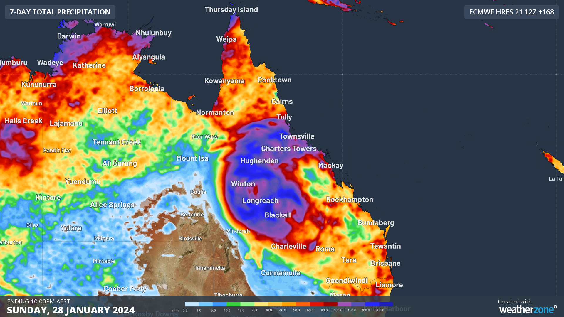
Image: Forecast accumulated rain during the 7 days ending on Sunday, January 28, 2024, according to the ECMWF-HRES model.
The inland rain from Ex-Tropical Cyclone Kirrily has the potential to cause flooding over a broad area of eastern Australia.
Anyone living in Qld should carefully monitor the latest forecasts and warnings around soon-to-be Tropical Cyclone Kirrily. DTN APAC, specialises in industry-leading forecast, alerting and threat analysis of tropical cyclones, offering you expert, customised solutions when the weather turns wild. For more information, please contact us at apac.sales@dtn.com.


