East Asia experienced significant drops in temperatures this weekend, which could lead to flooding rainfall over Indonesia and tropical cyclones in the Australian region. But how?
After reaching maximum temperatures of about 25°C during the day, Hong Kong experienced a cool change on Saturday evening as a cool and dry northerly wind reached the territory. Maximum temperatures struggled to reach 20°C on Sunday and are expected to remain in the low 20s over the first half of the week. A similar story occurred throughout the East Asian region, and this surge of cold air could trigger heavy rainfall and tropical cyclones near Australia and Indonesia over the next week and a half.
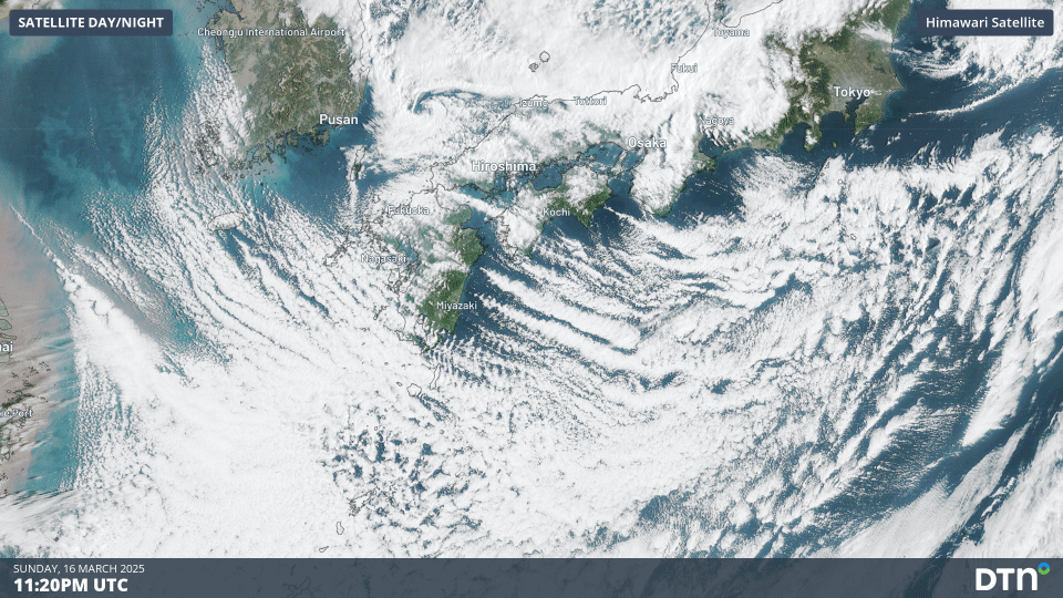
Image: Satellite loop of cloud streets streaming off Japan on Monday, March 17, 2025, as cold air moves over warmer waters.
This surge of cold air originated from deep over the Tibetan plateau, where very cold and dry air during the boreal winter descends into a dominant high pressure system. These cold and dry winds expand east and south into Japan and China, becoming the northeast monsoon as they travel into the South China Sea, picking up moisture over the increasingly warm oceans. The image below shows the cold air moving over China, the Korean Peninsula and Japan over the weekend.
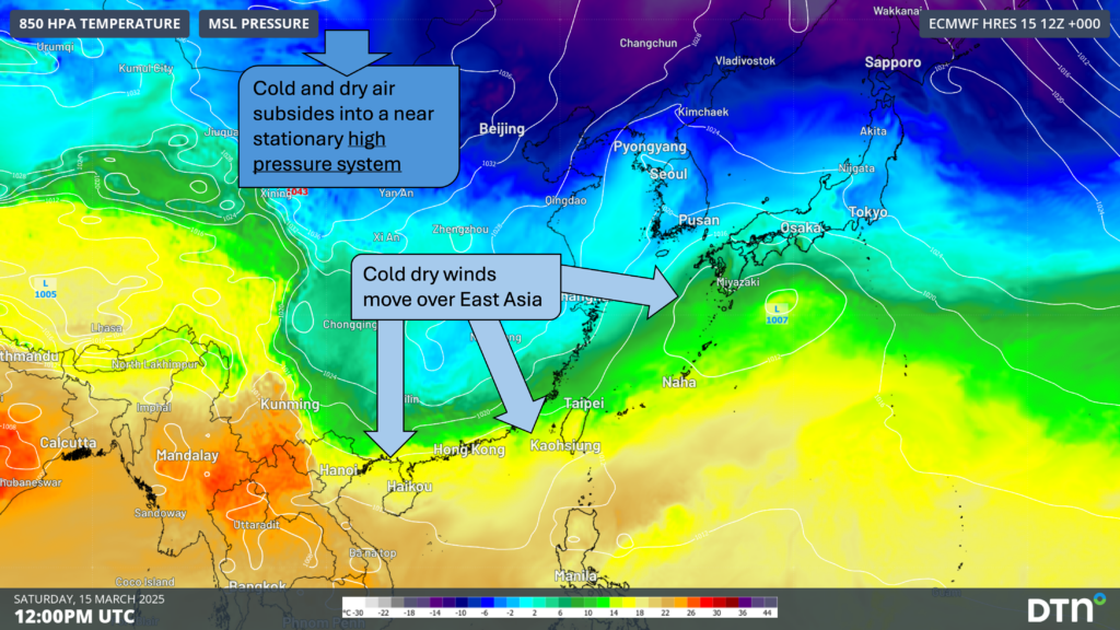
Image: 850hPa temperature over Asia on Saturday, March 15, showing cold dry winds from the interior of the continent moving into East Asia.
The northeast winds, now loaded with moisture, approach the equator, where they turn northerly and then northwesterly into the Southern Hemisphere due to the Coriolis Effect. This burst of moisture-laden northwesterly winds moving over Indonesia and northern Australia is the Australian Monsoon.
The loop below shows that northeasterly winds will remain active over the remainder of the coming week, surging during the mid-week period. Northwesterly winds will strengthen mid-week over Sumatra and western Java, before reaching into eastern Java and nearby the Australian mainland later in the week.
Image: Loop of weather modelled 950hPa winds over the coming week across southeast Asia, Indonesia and northwestern Australia. Source: Andrew Miskelly
Flooding over Singapore and Indonesia
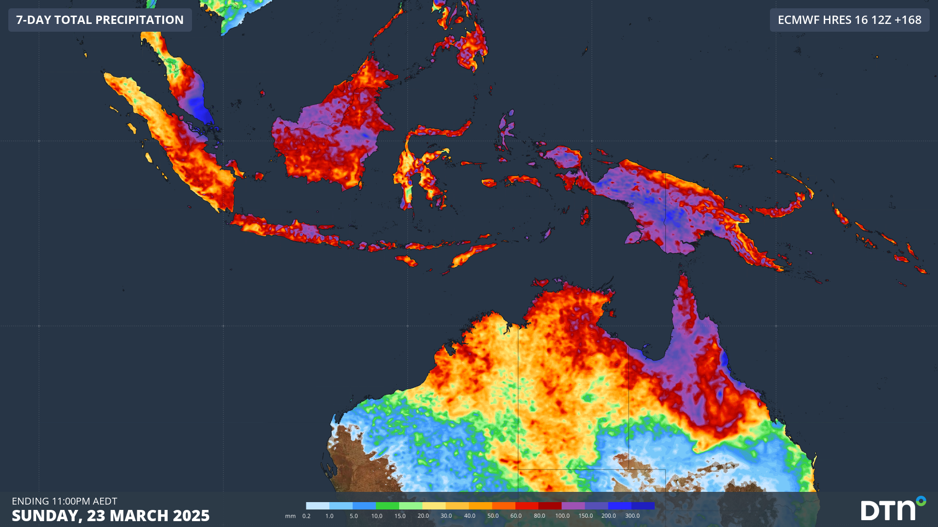
The surge of northeast monsoon winds will bring heavy rainfall leading to flooding over parts of the Malay Peninsula, Singapore and eastern Sumatra between Wednesday and Friday, before easing into the weekend. Weekly rainfall totals over the region should amount to 400-600mm, as seen in the image below. Totals of 100-200mm are also expected over other parts of Sumatra, Java and Kalimantan as the moist winds turn northwesterly over the region.
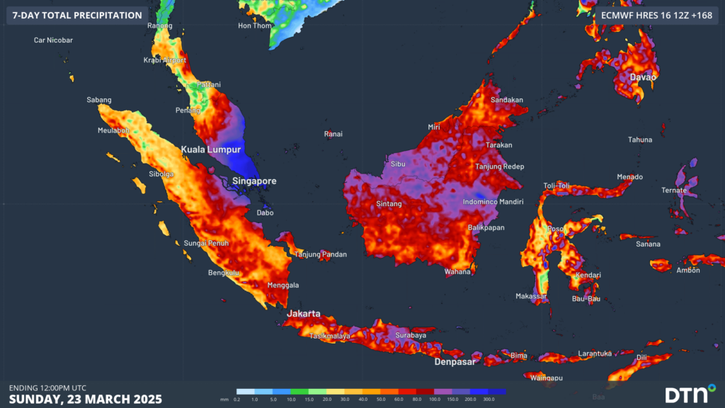
Image: forecast weekly rainfall across Indonesia and the Malay Peninsula according to ECMWF weather model.
Tropical Cyclone risk increases for Australia
The surge of northwesterly winds crossing the equator will combine this week with a burst of the Madden-Julian Oscillation (MJO). The MJO moves around the equator from west to east as a burst of westerly winds which bring enhanced convection and can lead to the formation of tropical cyclones. As is shown in the image below, the greatest risk of tropical cyclones is found to the northwest of Australia this week.
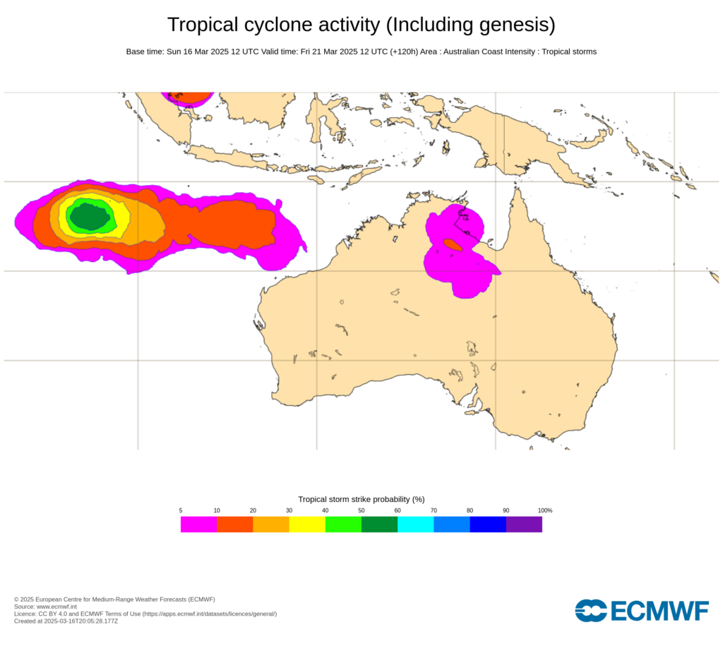
Image: ECMWF Tropical Cyclone probabilities on Friday, March 21, around Australia. Source: ECMWF
A tropical low (25U) near the Cocos (Keeling) Islands sees a moderate chance of becoming a tropical cyclone over the coming week, but will remain well away from the mainland. Another tropical low (27U) could form later in the week to the northwest of WA’s Pilbara with the surge of westerly winds moving east over Indonesia, with potential for this tropical low to move closer to the northwest of Australia next weekend and into next week. If one of these lows does intensify into a tropical cyclone in the Australian region, it will be named Courtney.
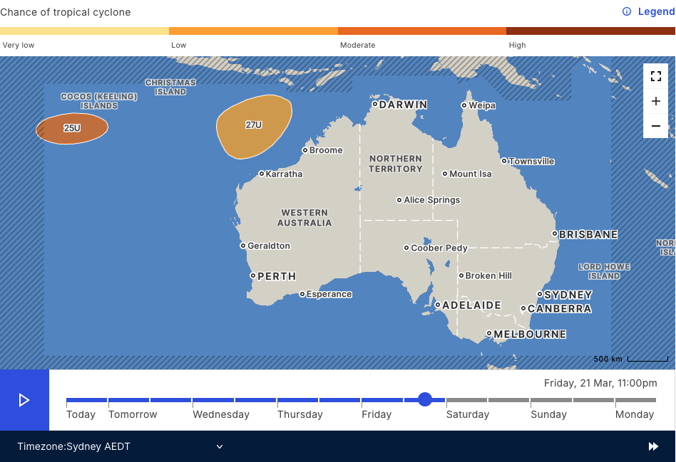
Image: The Bureau of Meteorology tropical cyclone forecast for Friday, March 21, showing a moderate chance of tropical low 25U being a tropical cyclone, and a low chance for tropical low 27U. Source: Bureau of Meteorology.
The next week and a half to two weeks should remain active across the Australian tropics as the surge of cross-equatorial winds subsides next week and the MJO moves over the region.
Return of the Monsoon in Darwin
After a relatively dry start to March in Darwin, with the running monthly rainfall at 100mm (the March average is 310mm), rain is set to increase over the Top End during the next week. A deep stream of northwesterly winds extending well into the atmosphere could mark the return of the Monsoon with its heavy rainfall and squally storms, although there is some model uncertainty as to whether the monsoon makes it to Darwin or remains further north.
How DTN APAC can help
Tropical Cyclone Services
As the climate delivers increasingly severe weather events, their potential to impact your business operations grows.
DTN APAC, specialises in industry-leading forecast, alerting and threat analysis of tropical cyclones, offering you expert, customised solutions when the weather turns wild.
Providing rapid-update forecast information, we alert you to any low-pressure system gaining power within your region and, unlike other providers, can track its development out to 7 days. This gives you the time to prepare and safeguard your staff, sites and assets.
You will have the most precise weather intelligence charting rainfall, wind speeds and potential storm surges to help you make critical decisions quickly. Whether it’s adjusting key work schedules, protecting your staff or securing your site, we have the alerting capability to keep you steps ahead of the storm.
We will support you, 24/7, keeping you informed and making your critical decisions easier.
Flood Risk System (FRS)
DTN APAC, delivers the Flood Risk System (FRS) to provide flood risk visibility. You can now easily visualise precipitation, and access rapid-update forecasting, across multiple sections of your site with the FRS geofenced alerting system. Gain a more precise determination with DTN APAC’s advanced geospatial technology creating hundreds of virtual ‘weather stations’ for each monitored section or culvert.
Rainfall is measured across each of your established catchments, with alerting calibrated to their individual thresholds. Alerts are raised when thresholds for any section are approaching or have been breached. This gives you targeted risk visibility to inform your assessment, operational response and emergency management.
The FRS can be integrated into your existing DTN APAC interface, or your own monitoring and control systems. Real-time monitoring of each catchment’s predefined thresholds is coupled with forecasting of rain, so you can provide your team with the most up-to-date information on whether conditions will ease, continue, or worsen.
To find out more about large range of products and services contact us at sales.apac@dtn.com


