An outbreak of severe thunderstorms and damaging winds will affect Australia during the next three days, impacting at least five states and territories.
A series of upper-level troughs interacting with an unstable atmosphere, copious moisture and numerous surface-based low pressure systems and troughs will provide an ideal environment for prolific storm activity across the southern half of Australia during the next 72 hours.
On Wednesday, showers and thunderstorms will develop over a broad area of southeastern and southwestern Australia.
The maps below show the forecast accumulated rainfall over southeastern and southwestern Australia on Wednesday, giving an indication of where the rain and storms will occur.
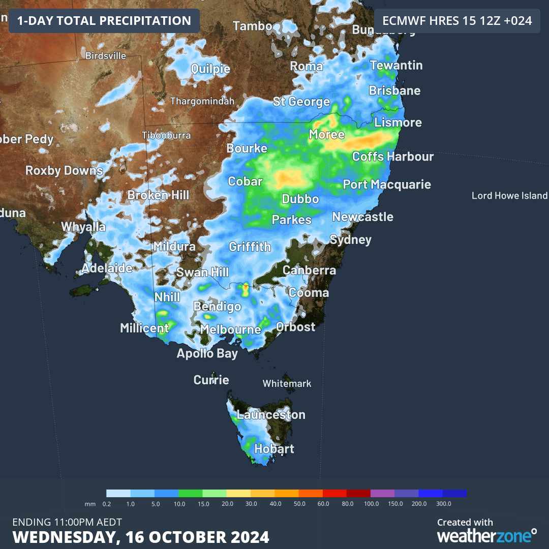
Image: Forecast accumulated rain during the 24 hours ending at 11pm AEDT on Wednesday.
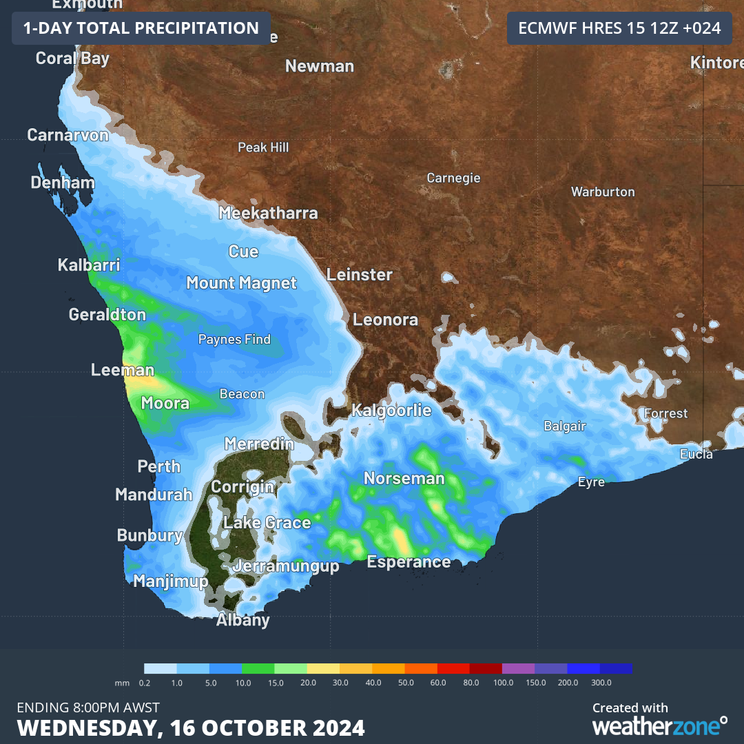
Image: Forecast accumulated rain during the 24 hours ending at 8pm AWST on Wednesday.
The storms in the southeast on Wednesday will affect parts of NSW, Vic, SA and southern Qld. Some of these storms may become severe, most likely over inland areas of northeast NSW and southeast Qld during the afternoon and early evening.
The storms in WA on Wednesday will target the west and south of the state. Severe storms are possible, with ample wind shear (a change in wind speed and direction with height) increasing the risk of damaging winds with any storms that develop. The system responsible for storms over WA on Wednesday will shift further east on Thursday, causing showers and dangerous thunderstorms to spread across SA and parts of Vic, NSW and the NT. This is likely to involve severe storms in multiple states, with damaging to destructive winds, large hail and bursts of heavy rain all a risk.
A surge of powerful winds will also sweep across SA on Thursday, with damaging winds likely to develop over the state’s north and west, where a severe weather warning has been issued.
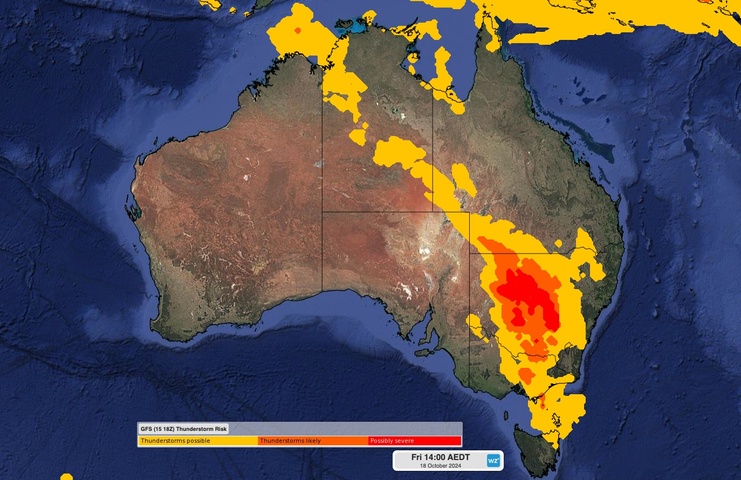
Rain and thunderstorms will continue to spread across southeastern and eastern Australia on Friday as the low pressure system and trough move further east. Parts of NSW, Vic, the ACT, Tas and Qld will be affected by wet and stormy weather on Friday, with severe storms likely in most of these states. The setup on Friday will be conducive to multi-cell thunderstorms and squall lines, and possibly supercells. These types of storms increase the risk of destructive winds and very large hail.

Image: Thunderstorm risk map for Friday afternoon.
Severe thunderstorm and severe weather warnings will be issued in multiple states over the next three days, so be sure to check the latest warnings for the most up-to-date information.
Title image credit: iStock / Philip Thurston
DTN APAC, a DTN company, offers precise weather intelligence and alerting to protect your utilities network when severe weather, floods and fires threaten.
Over 80% of Australian transmission and distribution networks already rely on our proven nowcasting and forecasting out to 15 days. You can rest assured yours is protected by market-leading analysis. With this foresight you can gain lead time to prepare for possible outages, reduce risk and protect your people and profits.
You will never be left in the dark when conditions suddenly worsen. We deliver reliable, up-to-the-minute weather forecasts and analytical tools that give you the power to enhance your operational management and response to weather risk. Our Total Lightning Network is a globally proven solution that accurately identifies and alerts you to lightning strikes within your defined thresholds, supporting the safety of your team.
Your customisable interface has GIS mapping, showing multiple weather layers over your utilities network and offering full situational awareness. You can quickly recognise any threat to your assets in real time. 24-hour asset monitoring allows you to track lightning, bushfires and other severe weather systems that approach your service territory.
Advanced and actionable analytics allow you to act decisively and improve your planning and outage response strategy. Keep the power on this season with Storm Impact Analytics;
- Understand potential outage risk
- Learn from past events and provide accurate restoration timelines for customers
- Restore power faster by managing response teams
- Gain powerful decision-making support
Utilities that have installed Storm Impact Analytics have reported a 39% increase in customer satisfaction. To find out more visit our contact page or email us at apac.sales@dtn.com.


