Blustery winds are impacting parts of southeastern Australia on Tuesday, bringing some of the strongest winds some locations have seen in a year.
Damaging winds lashed parts of Tas, NSW, Vic on Tuesday, July 16 at the following locations:
- Mount Hotham in Vic recorded a mean wind speed of 83 km/h and a 101 km/h wind gust at 8:30am
- Thredbo Top stations saw a mean wind speed of 83km/h and a 100km/h gust at 12:30am
- Larapunda in Tas recorded a mean wind speed of 72 km/h at 1:30pm
- Williamtown in NSW saw a mean wind of 65km/h at 12:22pm
- Cape Nelson lighthouse recorded a mean wind of 63km/h at 3am
- Grampians in Vic saw a 70km/h mean wind speed at 2am
While just below damaging strength, Williamtown and Albion Park in NSW recorded a 79.6km/h gust and an 87km/h gust respectively early Tuesday morning. Port Fairy in Vic recorded a 75.9km/h gust. These are the strongest gusts these locations have seen in a year.
The fierce winds impacting the region on Tuesday are being driven by a deep low-pressure system in the Tasman Sea and a tight pressure gradient between the low and a high-pressure system sitting in the Bight. This setup is bringing a prolonged period of strong southerly winds and cool temperatures to the region.
The video below shows the low and associated cloud spinning clockwise to the east of Tasmania and clouds moving from south to north in a strong south to westerly flow.
Video: Himawari-9 satellite image at 11:50am on Tuesday, July 16.
These winds caused wind power to peak at 7641MW early Tuesday morning, the most wind that the National Electricity Market (NEM) has seen this week.
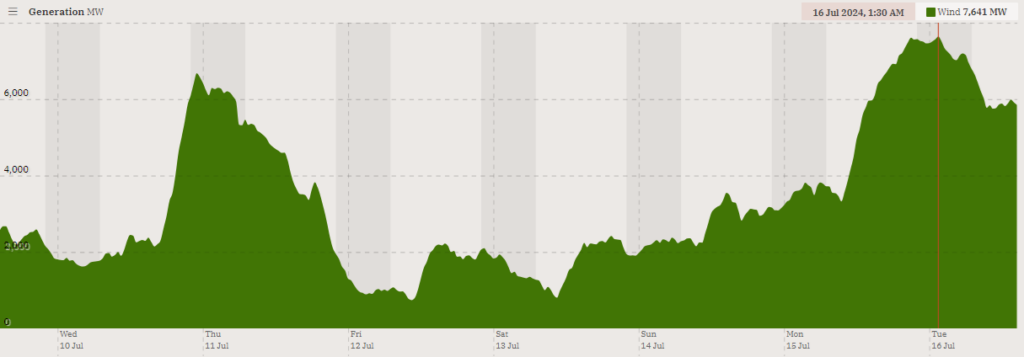
Image: NEM Wind contribution to generation for the last 7 days leading up to Tuesday afternoon, July 16. Source: OpenNEM
While winds have eased below damaging strength in the southeast Tuesday afternoon, strong winds will continue for the rest of Tuesday into Wednesday, as the low lingers off the NSW coast.
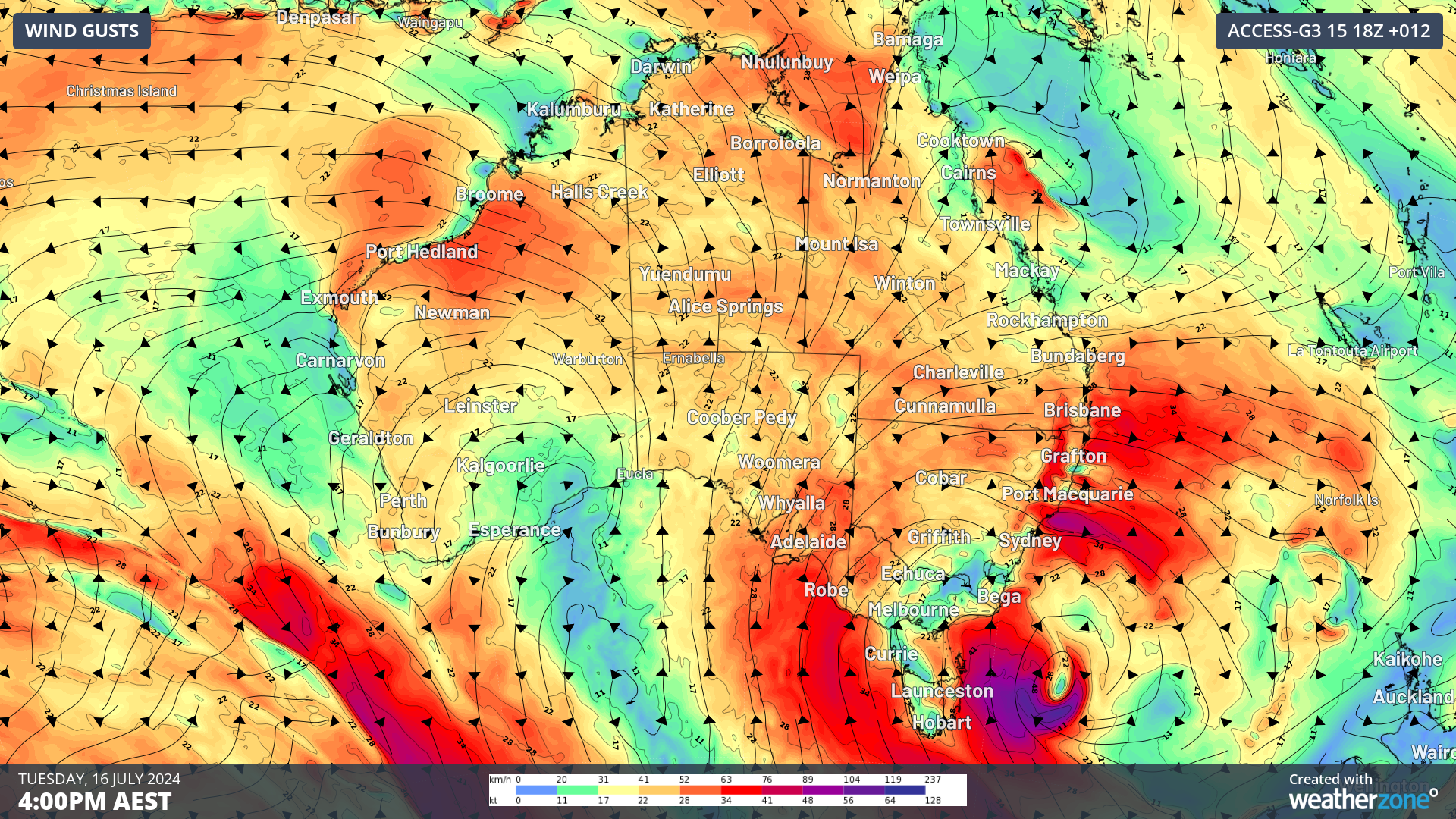
The image below shows the instantaneous wind gust forecast on Tuesday and Wednesday afternoon.
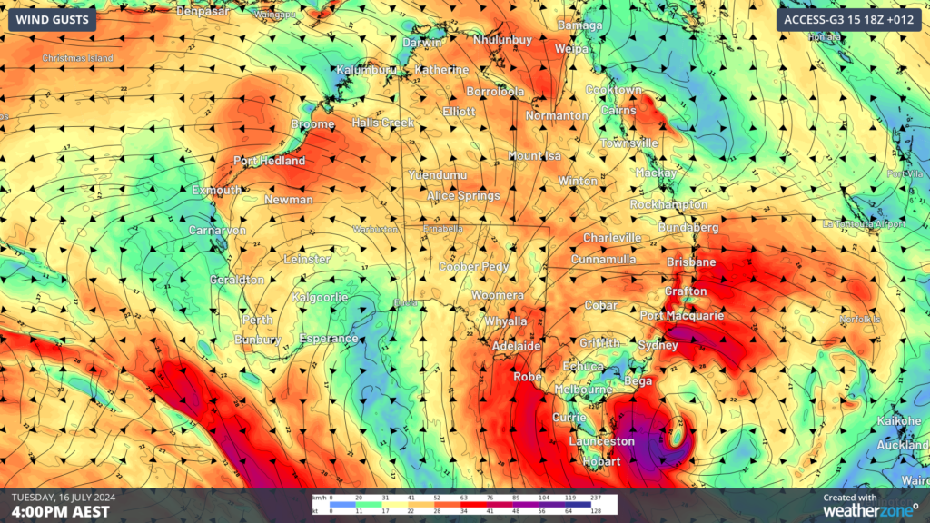
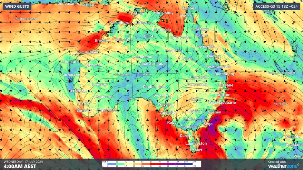
Image: Instantaneous wind gust forecast for 4pm on Tuesday, July 16 (top) and Wednesday (bottom), according to Access-G
Winds across the southeast should ease from Thursday briefly before a strong cold front sweeps across the region late this week, elevating wind again.
DTN APAC delivers industry-leading weather and power generation forecasting and real-time alerting to inform your critical decision-making. Together we can keep your staff and assets safe, and efficiency high.
With lightning strikes, severe weather, flood and fire posing risk to wind farms across Australia, we have tailored solutions that can significantly improve your oversight and response.
Total Lightning Network comprises of regional and global sensors to detect intra-cloud (IC) and cloud-to-ground lightning (CG) strikes within your proximity thresholds. It provides unparalled detection accuracy (<200m) and real-time lightning alerts to any device across your operations team.
Your customizable Energyzone interface and Weatherguard app will provide access to the Total Lightning Network as well as centralized data from state and territory fire agencies, the Bureau of Meteorology, and over 30 national and international private and state organisations. This enables full situational awareness of weather conditions and fire risk, as well as severe weather alerting via text, email and phone call, so your staff can respond effectively when required. To find out more, please visit our contact page or email us at apac.sales@dtn.com.


