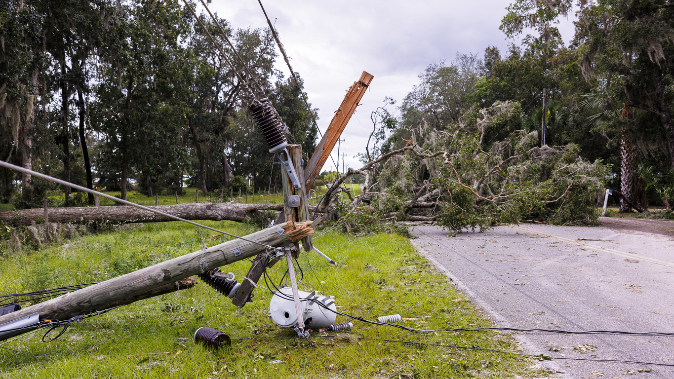
Ex-Tropical Cyclone Alfred brought intense rainfall and strong winds over the weekend, leaving about 450,000 homes across southeast Queensland and northeast NSW without power.
The video below shows heavy rainfall impacting southeast Queensland and northeast NSW on Sunday evening as the remnants of Tropical Cyclone Alfred moved inland.
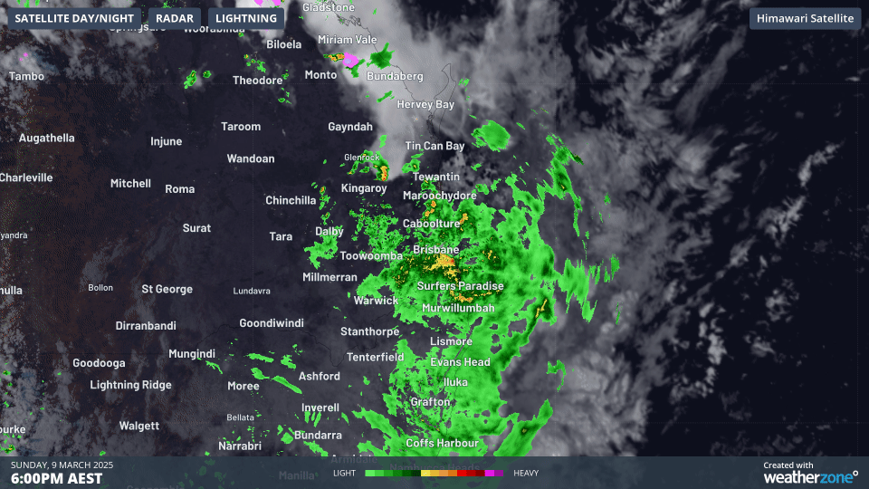
Image: Six-hour radar and satellite loop to midnight (AEST) showing a region of convergence in which Brisbane received 92mm of rain in the six hours period as bands of heavy rain (green and yellow on the radar) appeared to continually replenish themselves.
While Alfred’s strongest winds were found well offshore last week, the system still brought strong to gale-force winds to parts of the region as the system neared and crossed the coast. The fierce winds combined with the intense and heavy rainfall brought down trees over power lines, leading to widespread power outages across southeast Queensland and northeast NSW. Over 330,000 residents over the region were affected on Saturday, with over 200,000 remaining without power as of midday Monday.
Some of the strongest wind observations over the past few days include:
- A 120km/h gust at Cape Byron on Friday morning, with gusts of 100-105km/h and sustained winds of about 90km/h recorded each day from Wednesday to Saturday.
- Sustained 82km/h winds, gusting to 104km/h, at Redcliff in Brisbane’s northeast on Saturday evening.
- Mean wind speeds of 83km/h, gusting to 100km/h, at Gold Coast Seaway on Friday evening.
Some of these exposed locations experienced periods of gales within the range of a category 1 cyclone, which typically features sustained winds of 63 to 88km/h, and gusts up to 125km/h. It was however the combination of heavy and intense rainfall with these periods of gales, that lead to the widespread power outages. The heavy rainfall loosened the soil around trees, weakening the roots’ ability to withstand the strong winds, sending trees down onto power lines.
Some notable rainfall observations over the past days include:
- 275mm in the 24 hours to 9am for Brisbane, marking the wettest day since January 1974 (during the Brisbane River floods) and wettest March day since 1908.
- Over 1,100mm over the past five days at Springbrook, in the Gold Coast’s hinterland.
- 224mm in three hours at Hervey Bay early on Sunday morning.
The image below shows that widespread daily falls of 200 to 300mm across Brisbane and the Gold Coast were estimated by DTN’s MetStorm to 9am on Monday, March 10.
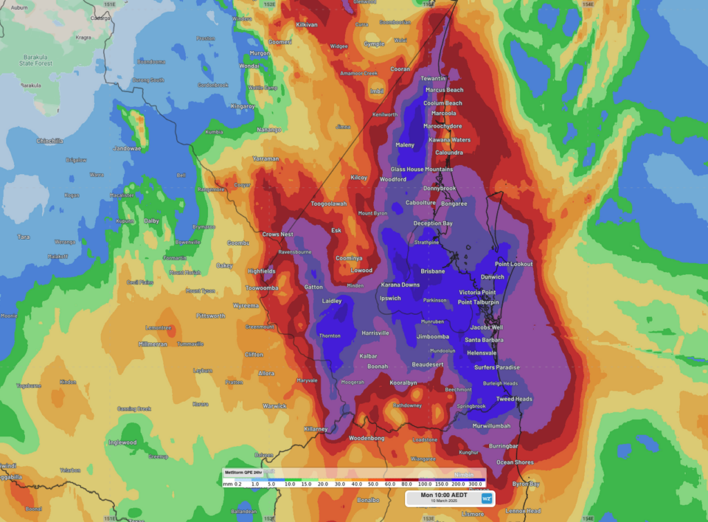
Picture: DTN’s MetStorm Quantitative Precipitation Estimate (QPE) showing estimated rainfall across southeast Queensland over the 24 hours to 9am AEST on Monday, March 10, with widespread falls of 200-300mm across Brisbane and the Gold Coast.
Flooding continues to affect broad parts of southeast Queensland and northeast NSW on Monday, with moderate to major flooding disrupting transport routes and blocking rescue efforts over the region.
Heavy rainfall over southeast Queensland and the NSW Northern Rivers is expected to ease this afternoon, with lighter showers persisting into the coming week, helping alleviate flooding effects and aiding the recovery effort. Heavy rainfall will persist over Tuesday and early Wednesday for parts of NSW’s North West Slopes and Plains, possibly extending into the Mid North Coast and northern Hunter, before clearing through the mid-week period.
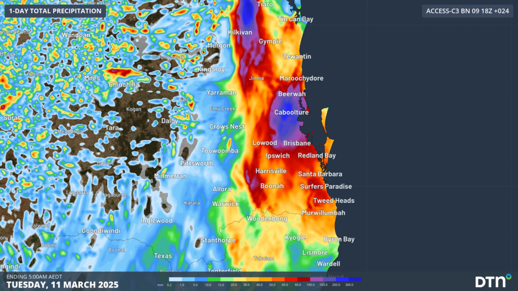
Picture: Rainfall accumulations across southeast Queensland in the 24 hours to 4am AEST on Tuesday.
How DTN APAC can help
Energy Power Networks and Utilities
DTN APAC, offers precise weather intelligence and alerting to protect your utilities network when severe weather, floods and fires threaten.
Over 80% of Australian transmission and distribution networks already rely on our proven nowcasting and forecasting out to 15 days. You can rest assured yours is protected by market-leading analysis. With this foresight you can gain lead time to prepare for possible outages, reduce risk and protect your people and profits.
We deliver reliable, up-to-the-minute weather forecasts and analytical tools that give you the power to enhance your operational management and response to weather risk. Our Total Lightning Network is a globally proven solution that accurately identifies and alerts you to lightning strikes within your defined thresholds, supporting the safety of your team.
Your customisable interface has GIS mapping, showing multiple weather layers over your utilities network and offering full situational awareness. You can quickly recognise any threat to your assets in real-time. 24-hour asset monitoring allows you to track lightning, bushfires and other severe weather systems that approach your service territory.
Advanced and actionable analytics allow you to act decisively and improve your planning and outage response strategy.
Transport Weather Solutions
DTN APAC specialises in building tailored weather monitoring and alerting solutions. These provide heightened visibility, guiding you to plan and respond effectively when adverse weather threatens transport operations. Our weather insights, including flood and fire proximity alerts, warn you of potential and real-time hazardous weather affecting water, rail and road conditions.
Your control interface delivers centralised services, password protected for your personnel. It’s purpose-built to meet your unique specifications, delivering easy-to-visualise critical intelligence that is scalable. Industry-leading lightning detection, GIS storm tracking, nowcasting, forecasting and severe conditions alerting are the foundation of the weather API. You then have the option to layer additional premium solutions to meet your unique requirements.
Leverage our comprehensive weather data to inform your route planning, minimise delays where possible, and mitigate the disruptive effects of severe weather events.
To find out more about our large range of products and services contact us at sales.apac@dtn.com
Thumbnail image: iStock/Alex Potemkin


