Australia’s alpine regions have seen a number of cold fronts during June and July delivering the best July snow depth in four years, maintaining steady levels of hydro electrical power.
The depth at Spencers Creek (elevation 1830m, roughly halfway between the NSW resorts of Perisher and Thredbo) was around 160cm late last week.
Here’s how that compares to the officially recorded peak depth at Spencers Creek in July over the last four years:
- 2024: 124.6cm on July 30 (also the season peak)
- 2023: 131cm on July 13 (also the season peak)
- 2022: 129.5cm on July 27 (the season kept improving with a late peak of 232cm on September 20)
- 2021: 183.6cm on July 29 (the season peak)
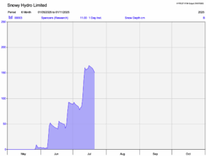
Image: Snowy Hydro uses two data sets. One is the average of a series of manual measurements. The second is a remote automated daily reading as shown above. Source: Snowy Hydro.
While the cold fronts in the past week has generally peaked too far south for significant mainland snow, it has been a different story in Tasmania.
Steady frontal passages have maintained ample hydro electrical power potential for Tasmania over the past week, with 155 GWh generated across Tasmania between July 14 and July 20. This accounted for 69.2% of the power generated by the state, and with 23.6% and 2% also generated by wind and solar power, respectively, only about 5% of Tasmania’s power came from non-renewable sources.
How DTN APAC services the hydropower industry
Using Opticast’s nowcasting and forecasting capabilities, you will have long-term outlook covering rainfall and extreme heat events out to 12 months. This can significantly improve your planning as you integrate the data with site-specific hydrological parameters.
DTN APAC’s Opticast is an ultra-local forecasting system, independently proven to be the best performing of its type in Australia. Providing an unprecedented level of accuracy and precision, Opticast rapidly updates every 10 minutes, intelligently adapting to local observations, and corrects forecasts based on historical evidence. Wherever you are based, we can provide you with the most accurate nowcasting and forecasting data out to 14 days so that you can mitigate operational and safety risks, and plan to make the most of severe weather windows.
With renewables making up more of Australia’s energy mix every year, we want to support your business to make informed critical decisions and improve your overall generation and safety.
Learn more about our large range of industry leading products and services or email us at sales.apac@dtn.com
Thumbnail image source: Erin McGrath (@ezzamcgrath on Instagram)


