
A frigid airmass will move across southeastern Australia late this week, dropping temperatures and some snow on the alpine peaks.
A strong cold front will sweep across the region on Sunday and Monday, leaving a cool airmass in its wake.
The image below shows forecast air temperatures around 1.5km above sea level on Sunday morning, showing the cool airmass moving over parts of SA, VIC, Tas and the ACT.
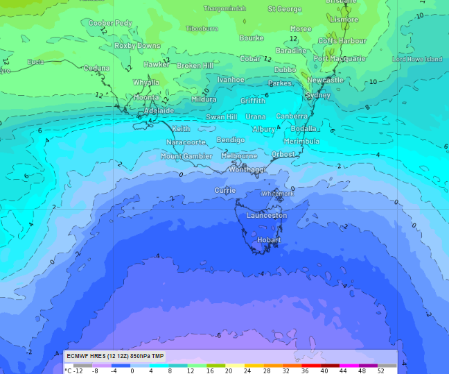
Image: 850hpa temperature at 2am Sunday, October 13.
Some of the notable temperatures across the southeast are;
- Melbourne’s temperature will fail to reach above 15-16°C, which is 4-5°C below average.
- Canberra’s minimum temperature will drop to 2°C on Monday night, about 4°C above average.
- Hobart’s daytime temperature will only reach 14°C on Monday
- Hobart will also see a run of cool nights with temperatures cooling to 5-6°C from Saturday night to Tuesday.
- Thredbo and Mount Hotham will have a freezing night Monday, with temperatures dropping to -4°C Monday night.
These temperatures are cool enough that snow should fall on the alpine peaks on Sunday and Monday. Snow could fall to 1300 metres in the Snowy Mountains on Monday as the coolest air moves over the mountains.
Fierce winds will also accompany this cold front, which could make the temperature feel much cooler.
While this weather isn’t unusual for October, this cold spell could feel particularly cool after parts of Vic, the ACT and NSW saw the warmest September on record.
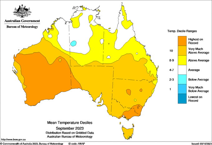
Image: Mean temperature deciles for September 2023 showing part
Fortunately, temperatures will warm up again mid-week as warm northwesterly winds return to the region ahead of a cold front.
As this event unfolds over the weekend, keep an eye out for the latest warnings here.
When your renewables energy operations are affected by weather extremes, we offer solutions to keep your productivity and profits high.
Weatherzone Business, a DTN company, supplies precise weather intelligence to over 75% of the National Energy Market (NEM) participants and is the trusted provider for Australia’s Market Operator.
We offer weather data and analytics to support all aspects of your renewables business, with a wide range of specialised services covering energy generation and weather forecasting, to site-specific severe weather alerting and historical reporting. For more information, please contact us at apac.sales@dtn.com.


