Halfway through autumn, Adelaide continues to endure an early-year dry spell the likes of which it has not seen since the famously barren decade of the 1980s.
- Just 14.4mm of rain has been recorded at the city’s main weather station from January 1 to April 15, 2025.
- That makes it the South Australian capital’s 4th-driest period on record from the start of the year to the mid-point of autumn.
- The only drier years from January 1 to April 15 were 1986 (11.4mm), 1989 (11.2mm) and 1980 (5.8mm).
- So Adelaide has not been this dry to start the year since 1989, 36 years ago.
As you’d expect with so little total rainfall, Adelaide has had just seven rain days (days with measurable rain of 0.2mm or more). This is the city’s equal-lowest number of rain days to this stage of the year, matching the seven days in 1986.
Reservoirs in the Mount Lofty catchment area in the Adelaide Hills are now at just 37%. This reflects not just the dry start to 2025, but the city’s long-running rainfall deficit.

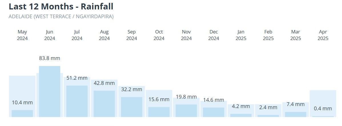
Image: The rainfall graph for Adelaide for the last 12 months (April is current to 9am, April 15) reveals that just one of the past 12 months has seen above-average rainfall.
Indeed, rainfall was the lowest on record in the 14-month period from February 1, 2024, to March 31, 2025, in most of the Eyre, Yorke and Fleurieu Peninsulas, as well as parts of SA’s Murraylands and Upper South East forecast districts.
Kangaroo Island and parts of western Victoria were also in record territory for rainfall deficiencies over that 14-month period.
READ MORE: The island that rain forgot
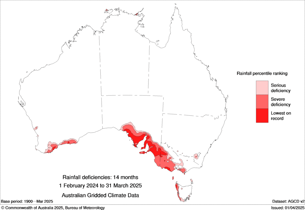
Image: Rainfall deficiencies in Australia from February 1 2024 to 31 March 2025. Source: BoM.
Ironically, parts of outback South Australia are now awash, as floodwaters surge towards the normally dry Kati Thanda-Lake Eyre from over the border after Queensland’s intense outback rainfall in March.
READ MORE: Watch desert floodwaters gushing towards Lake Eyre
In a further cruel irony for Adelaideans, parts of outback SA have seen more rain than the capital this year. Indeed, the famous opal mining town of Coober Pedy has received more than triple Adelaide’s rain to date in 2025, thanks to 47mm (across eight rain days) in March.
As an additional insult, Adelaide is currently sweating through a prolonged spell of very warm weather for mid-April, which is already the city’s second-hottest on record for April.
Tomorrow (Wednesday, April 16) should see the fifth day in a row where maximum temps have topped 32°C – and bear in mind that Adelaide’s average maximum in April is just 22.2°C.
The good news is that wet weather is coming with a low pressure system towards the end of this week. We won’t see drought-breaking rain, but southern parts of SA will likely see at least a few millimetres, in what is hopefully a taste of what’s to come as the winter wet season approaches.
Why has Adelaide and southern South Australia been so dry?
The image below shows the Mean Sea Level Pressure (MSLP) anomaly for the first three months of 2025. A strong high pressure signal over the lower Tasman Sea, extending over Tasmania and to the south of Australia is the area responsible for this prolonged dry spell. Anti-clockwise flow around the high (with clockwise flow around the low pressure) sends hot and dry inland air into South Australia.
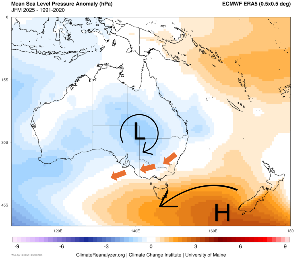
Image: Annotated mean sea level pressure anomaly for the first three months of 2025. Source: ClimateReanalyzer
Along with this, the persistent high pressure to the south of Australia has prevented cold fronts from making significant intrusions into southeastern Australia.
Dry conditions to extend into winter
The image below shows the forecast MSLP anomaly for June 2025. High pressure is expected to remain a dominant feature over southeastern Australia, keeping dry winds blowing from the interior into South Australia and southeast Australia.
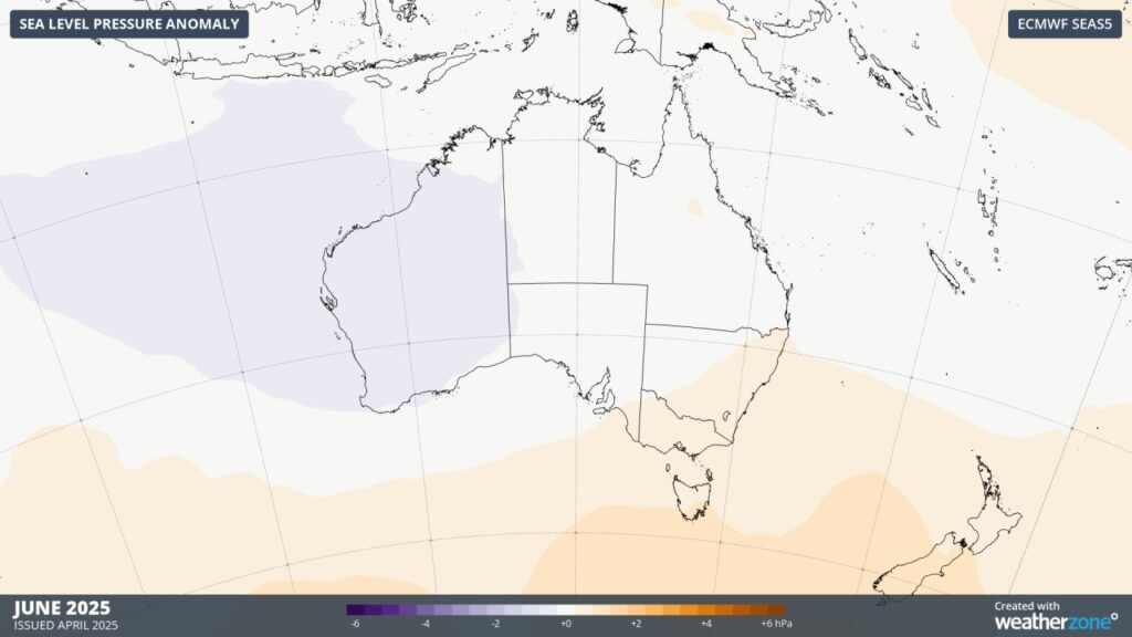
Image: Sea level pressure anomaly forecasted for June 2025.
This does not mean that southeastern Australia will be barren of rain bearing cold fronts. On average, blocking high pressure systems will likely lead to significant dry spells into the winter months, with a few frontal passages in between.
How DTN APAC can help
The shifting climate is bringing increased complexity and greater risks to businesses worldwide. We are here for you, delivering trusted weather solutions to optimize your operations and profitability.
DTN APAC is a diverse team, with global forecasting, product development and analytics expertise. Couple this with extensive industry experience spanning Aviation to Energy, and we are primed to assist you in strengthening your response to weather impact.
We work hard to identify your operational pressures and tailor our services and products to meet your needs. Concise communication, giving you full situational awareness exactly when you need it, is our focus. We want to reduce weather risk in your operations, every day.
We deliver clear and comprehensive weather data, personalised risk assessments and briefings to you and your team, so that your critical decisions can be made with confidence.
We are available 365 days a year, so you always have the timely guidance you require, especially when severe conditions hit.
You have our insights to rely on to see you through complex situations, minimising potential loss of profit and maximising the safety of your staff and assets. To find out more about large range of products and services contact us at sales.apac@dtn.com


