Early last month, we said that May would be a make-or-break month for the positive Indian Ocean Dipole (IOD) that could be forming this year. Turns out, it has most likely broken.
A positive IOD occurs when the trade winds along the equator blow to the west instead of the east, causing an upwelling of cold water near Indonesia, and warm waters to congregate near Africa. When the pattern is established, Australia tends to see far less rainfall move from the northwest of the country to the southeast in the form of cloudbands.
Back in early May, there were strong signs that a second consecutive positive IOD could develop. The main pieces that were starting to fit together were:
- Strong southeasterly winds across the southern Indian Ocean
- Upwelling occurring off the Indonesian island of Java
- Near record warm oceans near the Horn of Africa
- Warm waters in the Bay of Bengal
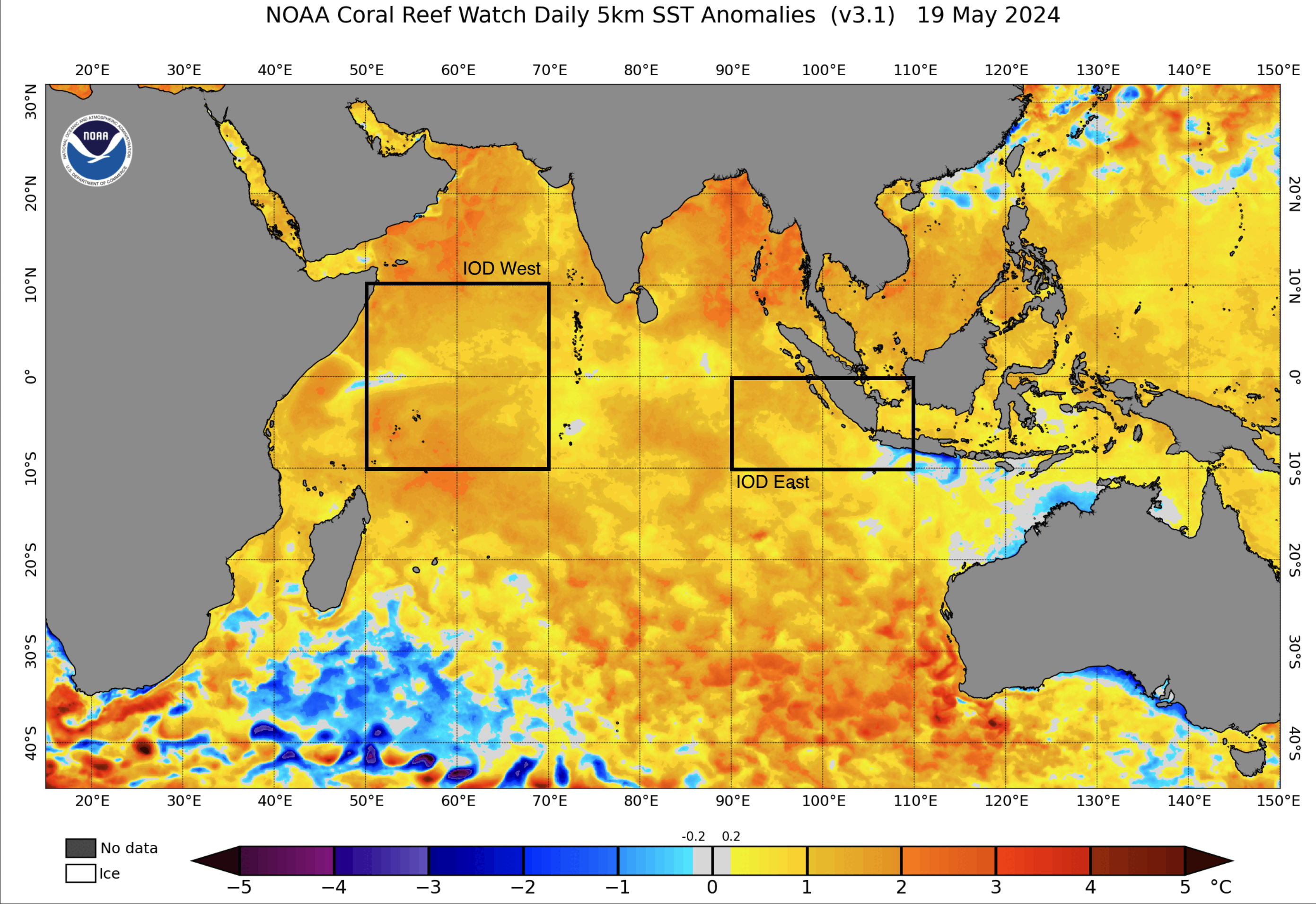
Image: Sea Surface Temperature anomalies on May 19, 2024. Cool waters in the IOD East and warm waters in IOD West indicate a positive IOD pattern developing.
However, there was a big caveat to that May forecast: tropical activity during the month had the potential to help or hinder the formation of the positive IOD this year. It can do this by changing atmospheric patterns, and causing cold water to upwell beneath stronger systems, like tropical cyclones.
During May, there were three significant tropical cyclones in the Indian Ocean, each upwelling cool waters in locations that set back the formation of a positive Indian Ocean Dipole.
Two out-of-season tropical cyclones formed quite close to the equator near Africa, being named Tropical Cyclone Hidaya and Tropical Cyclone Ialy. Both of these systems were Category 2 strength on the Australian scale, with winds peaking at 140km/h and 120km/h respectively, and brought heavy rainfall to Tanzania and Kenya.
Together, these tropical cyclones cooled waters in and near the ‘IOD West’ region by up to 4 degrees. Furthermore, they altered the overall pattern of winds, allowing coastal upwelling of cold water to start near the Horn of Africa. Since winds generally move from cooler locations to warmer ones (like with a sea breeze), westerly winds have started to increase in the western Indian Ocean.
Over in the Bay of Bengal, Severe Cyclonic Storm Remal also reached the equivalent of a Category 2 system on the Australian scale, with winds up to 140km/h before making landfall over northeastern India and Bangladesh. Upwelling of water in the Bay of Bengal reduced ocean temperatures by 3-4 degrees but did so over a very large area.
While tropical cyclones in the Bay of Bengal during April and May have been known to kick off a positive Indian Ocean Dipole, this cyclone essentially hit the ‘reset’ switch, in that the conditions to create a positive IOD now have to start from scratch.
Finally, the strong pulse of tropical activity changed the wind patterns in the Indian Ocean. Westerly winds were much stronger than normal in the centre of the Basin, and southeasterly winds eased off near Indonesia. Since coastal upwelling there relies on constant southeasterly winds, the disturbance in May was enough to stop the upwelling and warm up the surrounding waters.
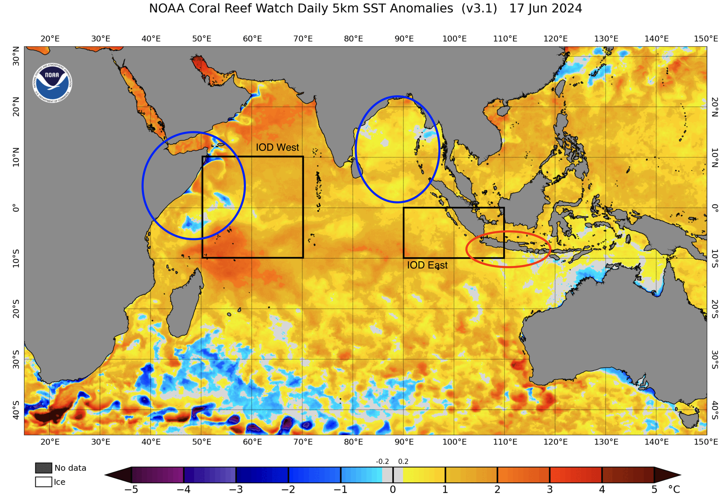
Image: Sea Surface Temperature anomalies on June 17, 2024. Areas of cooling are circled in blue, and areas of warming are circled in red.
Now that most of the conditions that were building the positive IOD have been disrupted, the IOD index has returned to near-zero. This means that is it now much less likely that a positive IOD will develop this year, and the IOD will most likely remain neutral. With a neutral IOD, northwest cloudbands can bring rainfall to the southeast of Australia, much to the relief of South Australia in particular which had its 2nd driest autumn on record.
Read more: What is a Northwest Cloudband?
These changes mean that all major climate drivers affecting Australia are expected to be neutral in winter and early spring. Consequently, most of Australia is forecast to see average rainfall over the coming months.
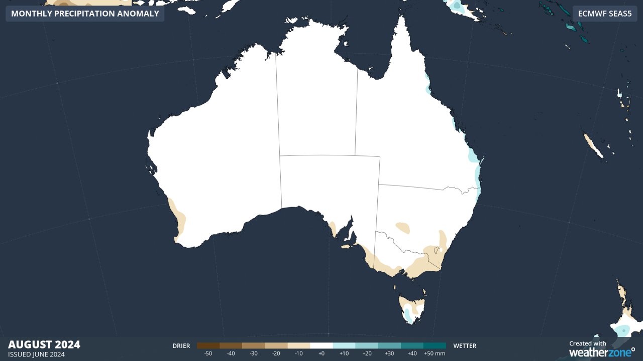
Image: Forecast rainfall anomalies for August. Areas in white are expected to be near average. See more at the Climate Page on Weatherzone.
The changes that occurred in the Indian Ocean during May are a perfect illustration of the ‘Autumn Predictability Barrier’. During autumn, accuracy of climate forecasts reduces, because tropical cyclones and disturbances can disrupt the developing climate drivers. Therefore, climate forecasts produced during those months should be considered more cautiously than those produced during winter and spring.
DTN APAC can provide tailored climate briefings by our climate experts to your business to alert you of the most likely weather conditions and hazards to look out for during the upcoming season. Now is a good time to get a good look at the forecast for winter, spring, and an early look into summer. To find out more or to book a presentation, please email apac.sales@dtn.com.


