Over 75,000 customers across southeast Queensland remain without power on Tuesday, after a peak of around 161,000 following the relatively brief, but intense severe thunderstorms complex that crossed the region on Monday afternoon. Damage to power utility networks and rescue efforts for residents was worse than those inflicted by Cyclone Alfred in March for some areas.
An outbreak of thunderstorms formed over far northeastern New South Wales on Monday and rapidly crossed the border, impacting densely populated areas along the coast and nearby hinterland and ranges from the Gold Coast to Bundaberg, including the Brisbane Metropolitan and Sunshine Coast regions.
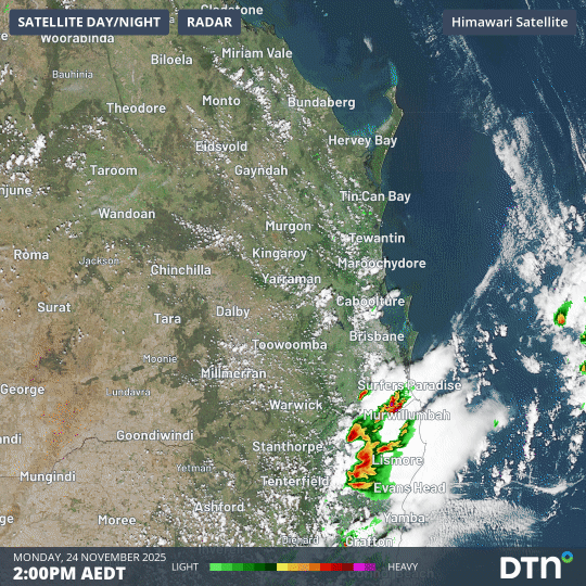
Image: Eight-hour loop showing radar and satellite imagery from 2pm to 10pm AEST in southeast Queensland and far northeast NSW on Monday, 24 November, 2025.
Some of the largest hailstones observed included:
- 14cm hailstones near Chandler around 3:00pm
- 11cm hailstones at Manly, Ferny Hills and Alexandra Hills around 3:30pm
- 9cm hailstones at Bunya around 3.24pm
- 9cm hailstones at Coombabah, Gold Coast, at 2:10pm
Some of the noteworthy rainfall totals (all of which fell in a brief period of around an hour or less) included:
- 79mm at Moreton Island
- 69mm at Upper Rous River/Hopkins Creek (on the NSW side of the border, just south of Lamington NP)
- 56mm at Hervey Bay
- 40.6mm at Maryborough
- 34.8mm at Tewantin
- 31.6mm at Brisbane Airport
- 29.4mm at Brisbane
Wind gusts exceeding 100 km/h were also reported during the storms in southeast Queensland, including at Brisbane Airport and on the Sunshine Coast.
The DTN Total Lightning Network reported over a million lightning strikes detected within 400 km of Brisbane on Monday, November 24, 2025, nearly 200,000 of which were ground strikes.
Flying tree branches, roofs and debris from these intense thunderstorms downed over 600 powerlines, resulting in over 161,000 energy customers without power on Monday. Power utility companies and contractors are hard at work on the recovery effort, but power restoration and clean up could still take days to be completed.
How did the storms form?
The three main ingredients for thunderstorms are:
- Instability
- Moisture
- Trigger
Atmospheric instability was abundant over southeast Queensland and northeast NSW on Monday due to warm air near the surface and much cooler, drier air aloft. This instability provided the lift required to build large thunderstorm clouds stretching thousands of metres into the sky.
There was also plenty of moisture available in the lower and middle levels of the atmosphere, providing ample fuel for storm clouds to become loaded with rain and hail.
Two significant triggers for storms were also present on Monday. The first being a ‘dry line’ sitting over southeast Queensland and northeast NSW, which is a zone where moisture-laden air to the east clashes with drier air to the west. The second trigger for storms was a southeasterly wind change moving towards the north throughout the afternoon and evening.
One additional ingredient that helped make Monday’s storms particularly dangerous was wind shear, which refers to the change in wind speed and direction with height. Strong wind shear over southeast Queensland and northeast NSW helped create rotation in thunderstorms, increasing the likelihood of supercells, which are the most violent and dangerous type of thunderstorm.
Why was the hail so large?
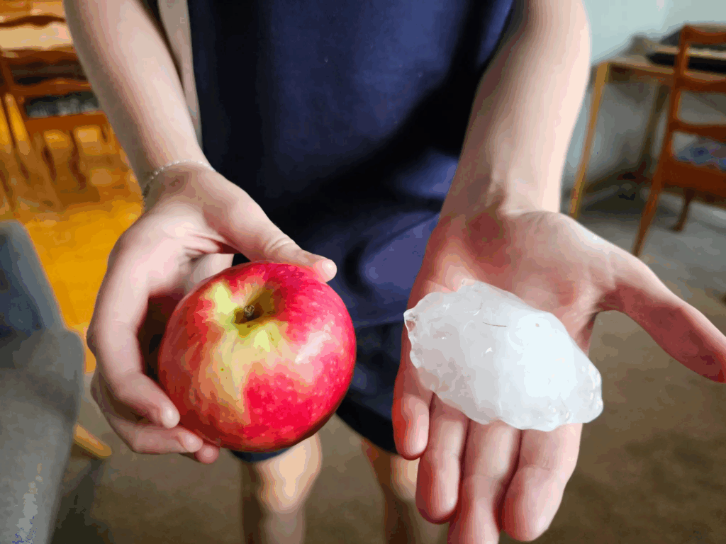
Image: Hailstones the size of apples fell in The Gap, Brisbane, on November 24, 2025. Source: Nick Gilpin (@nickgilpin) on Threads.
Hail forms when raindrops are carried high into the sky by a thunderstorm’s updraft. The hail grows larger when it collides with supercooled water droplets high in the storm cloud, which freeze onto the surface of the hailstone and make it grow.
Stronger thunderstorms have powerful updrafts that cause hailstones to rise and fall over and over, accumulating new layers of ice each time they lift into the cold upper-levels of the storm (that’s why you often see layers on a large hailstone resembling the rings inside an onion).
As mentioned above, all of the elements were in place for the development of severe thunderstorms, which meant the atmosphere was like a natural laboratory for the creation of giant hailstones.
What next for Brisbane and Southeast Queensland weather?
Afternoon or evening showers and thunderstorms are possible over the next three days from this Tuesday through to Thursday. The storms may be severe.
Days will be hot, sticky and uncomfortable right across southeast Queensland, with maximums in the low-to-mid thirties across the region. Inland temperatures will be a few degrees higher than those along the coast.
How DTN APAC is helping remote mining, transport, fire services and agricultural industries with advanced weather intelligence, remote sensing and now-casting solutions during the severe weather season
Australia is a vast country with densely populated coastal areas across the south and east, and millions of square kilometres of sparsely populated and rich in resources elsewhere. Typical radar coverage extends to a radius of about 200km, however mountains, trees and towers can restrict this optimal coverage range. Even with over 60 radar sites operating across Australia, vast expanses of the outback and WA remain outside of this traditional radar coverage, as seen in the left image below.
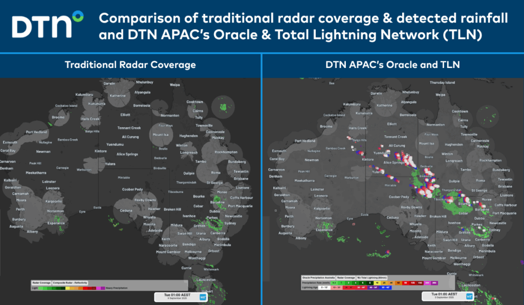
Image: Comparison of traditional radar coverage and detected rainfall (left), and DTN’s Oracle and TLN (right), across Australia at 1am AEST on Tuesday, September 9, 2025.
The image on the right shows DTN’s Oracle rainfall and Total Lightning Network detecting a vast area of rain and thunderstorms that would have been missed by traditional detection methods.
DTN Oracle
High-Resolution Modelling
Oracle is a satellite-derived, gridded nowcasting system. It forecasts out to 3 hours at a 1-2km resolution, and rapid updates every 5 minutes. With this enhanced forecasting detail, Oracle has the upper hand over 9-12km resolution models when capturing temperature, lightning, cloud cover, wind and rainfall. This ensures that no matter where you are in Australia, you will have access to precision nowcasting and forecasting that can rapidly inform your critical business decisions.
Greater Situational Awareness
Working in conjunction with DTN APAC’s Stormtracker GIS system, Oracle provides full situational awareness of any severe weather event that presents risk to your business. Short-term forecasting and severe weather alerts enable you to foresee the intensity and duration of events, so you can prioritise the safety and preparation of your staff and assets.
Whatever the weather, we provide the insights to help keep you and your team safe, productive and profitable.
DTN Total Lightning Network
Our Total Lightning Network is the intelligent lightning solution that goes above and beyond to alert lightning and increase your lead time before the storm hits.
We utilise a vast global sensor network, created with our partner Earth Networks. Over 1200 sensors in 40+ countries provide a worldwide view of both intra-cloud (IC) and cloud-to-ground (CG) lightning strikes, enabling businesses to plan and respond with the most precise insight available. Our system can detect and calculate strike locations with incredible accuracy, offering real-time lightning mapping for a comprehensive view of storm activity.
Offering unsurpassed accuracy, with real-time sensing to <200m, we integrate with your existing systems to keep your enterprise operating within your defined severe weather thresholds. Our technology also helps monitor radiation from electrical discharges and ensures every lightning flash is accounted for.
Leave nothing to chance. Be confident working outdoors with the most sophisticated lightning alerting system, delivering intelligence to any device across your business network. Whether you need a personal lightning alerting tool for individual safety or enterprise-wide monitoring, our solution is designed to emit timely alerts and protect your operations.
Learn more about our large range of industry leading products and services or email us at sales.apac@dtn.com
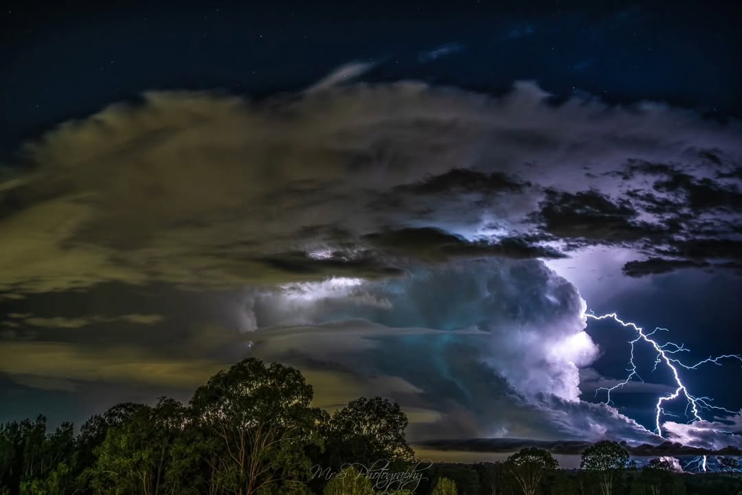
Thumbnail image source: @mr_s_photos via Instagram


