The National Energy Market (NEM) recorded its highest solar energy generation over the past summer as high pressure dominated southeastern Australia.
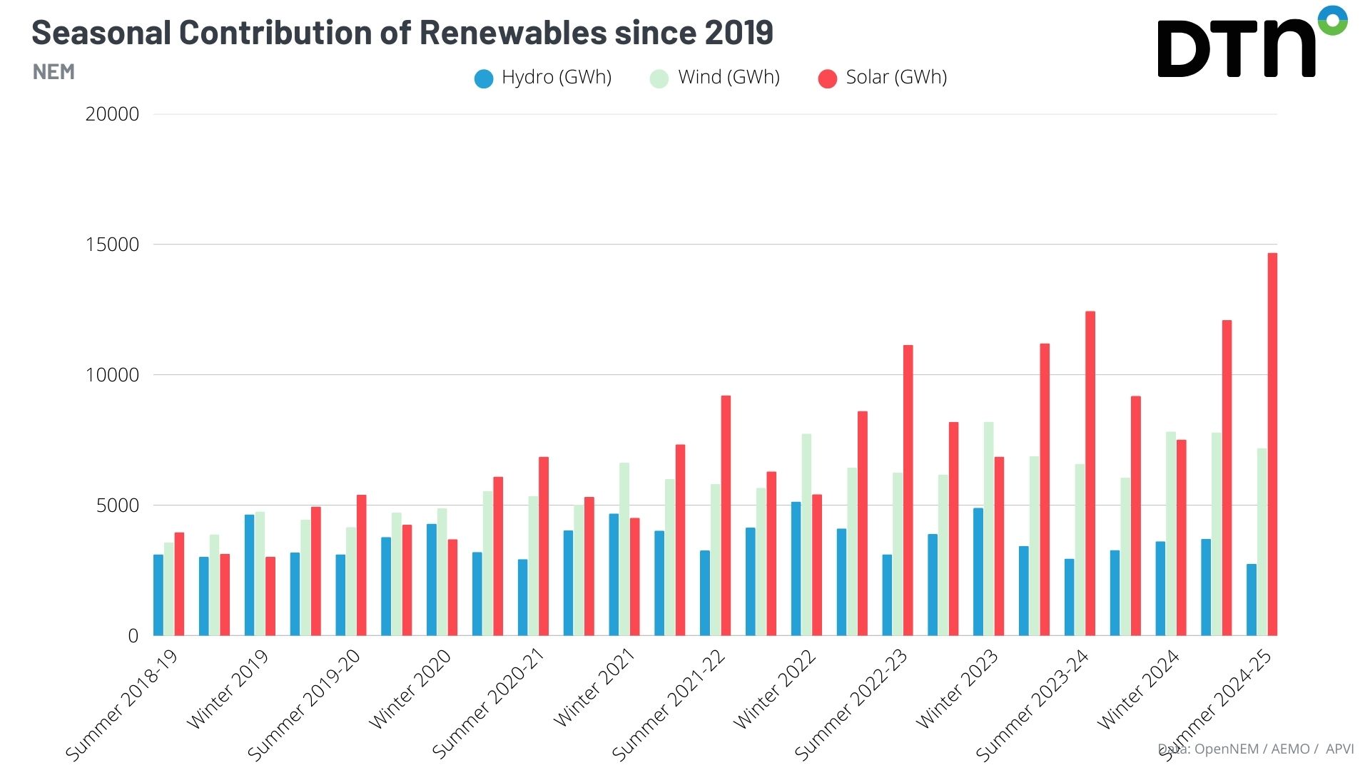
Australia’s NEM has continued to implement more and more renewable energy sources into its network. Combined with favourable weather, both the summer of 2024-25 and the last quarter (January to March 2025) saw record solar generation production, as seen in the image below.

Image: Seasonal contributions of renewables across the NEM since 2019. Source: OpenNEM.
As seen in the image below, high pressure has remained a steady feature across most of southeast Australia has kept cold fronts and moisture away from the solar generation zones of South Australia, Victoria and Tasmania – with ample solar radiation powering the NEM. As a result, solar energy dominated the renewable energy supply.
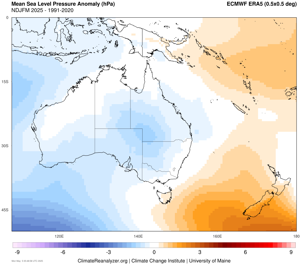
Image: Mean sea level pressure anomalies between November 2024 and March 2025. Source: ClimateReanalyzer
Wind energy generation
While fronts have been less active across southeastern Australia, the wind energy generation has remained steady with the increasing production capacity. The image below shows near or below average wind speeds across southern and eastern wind generation zones between November 2024 and March 2025.
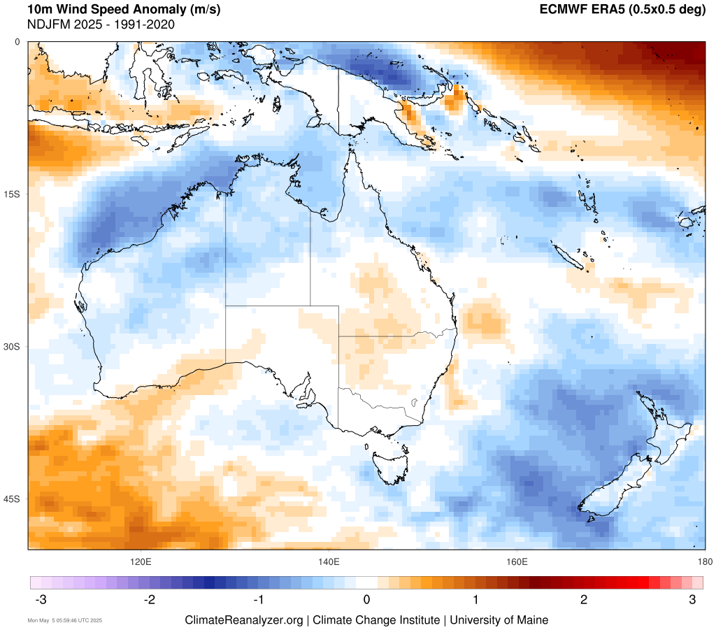
Image: 10 metre wind speed anomalies between November 2024 and March 2025. Source: ClimateReanalyzer
While strong enough winds are needed to get wind farms producing, excessively strong winds can damage the turbines. Propellers are typically stopped at a cut off wind speed of about 25m/s (equivalent to wind gusts exceeding 90km/h). Powerful cold fronts can easily exceed these speeds, so the lack of strong cold fronts has been beneficial for steady wind energy generation.
The broadening of renewables across all states has also decreased the NEM’s reliance on non-renewable energy sources. Summer is usually Queensland’s calmest month for wind, but increasing uptake in wind generation has led to a 66% increase this summer compared to the summer of 2021-22, and over four and a half times of the energy produced in the summer of 2019-20.
Hydro energy generation
Hydro generation has, however, seen a steady decline, with intense rainfall deficiencies plaguing parts of southeast Australia over the past two years. As a result, hydro generation throughout the summer season was at its lowest since 2014. With water supply becoming a growing concern, the NEM has been able to compensate with ample solar generation and steady wind supply.
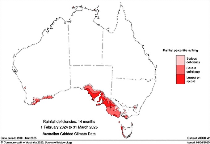
Image: Rainfall deficiencies in Australia from February 1 2024 to 31 March 2025. Source: BoM.
Outlook for the next few months
Higher than average pressure over Australia’s southeast is expected to persist through May and the start of winter, as shown by the image below. This should extend the ongoing streak of decreased cloud cover and cold fronts over southeastern Australia, promoting increased solar energy production. However, the lack of rain-bearing cold fronts will also prolong the rainfall deficiencies plaguing southern Australia during what are usually the wettest months of the year – a bad sign for water supply and hydroelectric generation.
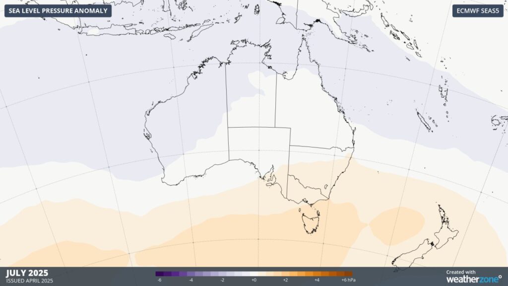
Image: Sea Level Pressure anomalies for July 2025.
Energy demand may also be lower due to warmer temperatures, especially across southern Australia, with fewer powerful cold fronts and ample warming sunshine. Spells of cold mornings are still possible, with high pressure leading to increased radiative cooling. However, on average, the coming months should see warmer-than-average temperatures over much of Australia, as seen in the image below.
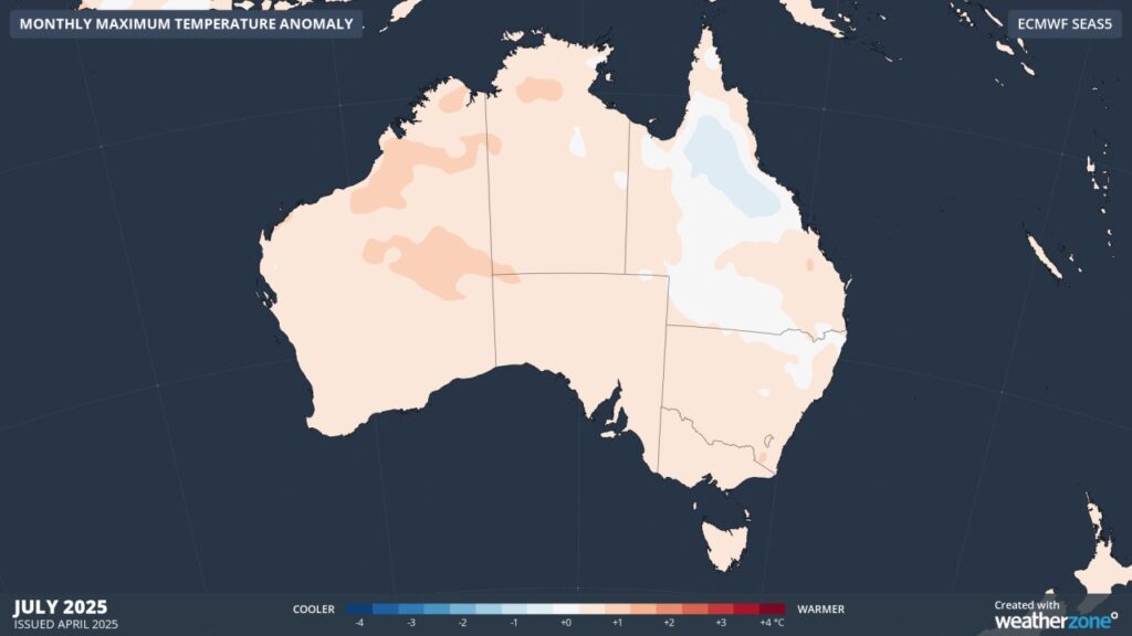
Image: Monthly maximum temperature anomalies for July 2025.
For an in-depth look, please read our winter outlook at:
Positive SAM and warm oceans dominate Australia’s winter outlook
How DTN APAC services the renewable energy sector
When your renewables energy operations are affected by weather extremes, we offer solutions to keep your productivity and profits high.
DTN APAC, supplies precise weather intelligence to over 75% of the National Energy Market (NEM) participants and is the trusted provider for Australia’s Market Operator.
We offer weather data and analytics to support all aspects of your renewables business, with a wide range of specialised services covering energy generation and weather forecasting, to site-specific severe weather alerting and historical reporting.
OpticastTM
DTN APAC operates Opticast, an ultra-local forecasting system, independently proven to be the best performing of its type in Australia. Providing an unprecedented level of accuracy and precision, Opticast rapidly updates every 10 minutes, intelligently adapting to local observations, and corrects forecasts based on historical evidence. Wherever you are based, we can provide you with the most accurate nowcasting and forecasting data out to 14 days so that you can mitigate operational and safety risks, and plan to make the most of severe weather windows.
Solar Forecasting and Generation
DTN APAC partners with Solcast, a DNV company – the world leader in real-time actuals and rapid-update solar forecasts.
Utilising Solcast’s satellite fleet, sky-imagers and the SCADA data collected from your solar farm, you will acquire not only forecasting capability, but a precise picture of your actual yield and PR. Specifically built to ensure you meet the requirements of the AEMO and reduce your exposure to costly penalties.
Wind
Utilising Opticast’s data, we provide wind power generation, operational and severe weather forecasting to improve your planning and protect your valuable staff and assets. Utilise generation forecasts for individual wind farms, state level and the NEM at daily and hourly resolution.
DTN APAC’s Total Lightning Network ensures your wind farm is protected from severe storms by an alerting system that can be configured to your exact requirements, aligning with local site needs, procedures and legislation.
Hydropower
Using Opticast’s nowcasting and forecasting capabilities, you will have long-term outlook covering rainfall and extreme heat events out to 12 months. This can significantly improve your planning as you integrate the data with site-specific hydrological parameters.
With renewables making up more of Australia’s energy mix every year, we want to support your business to make informed critical decisions and improve your overall generation and safety. For more information please visit our website or email us at sales.apac@dtn.com


