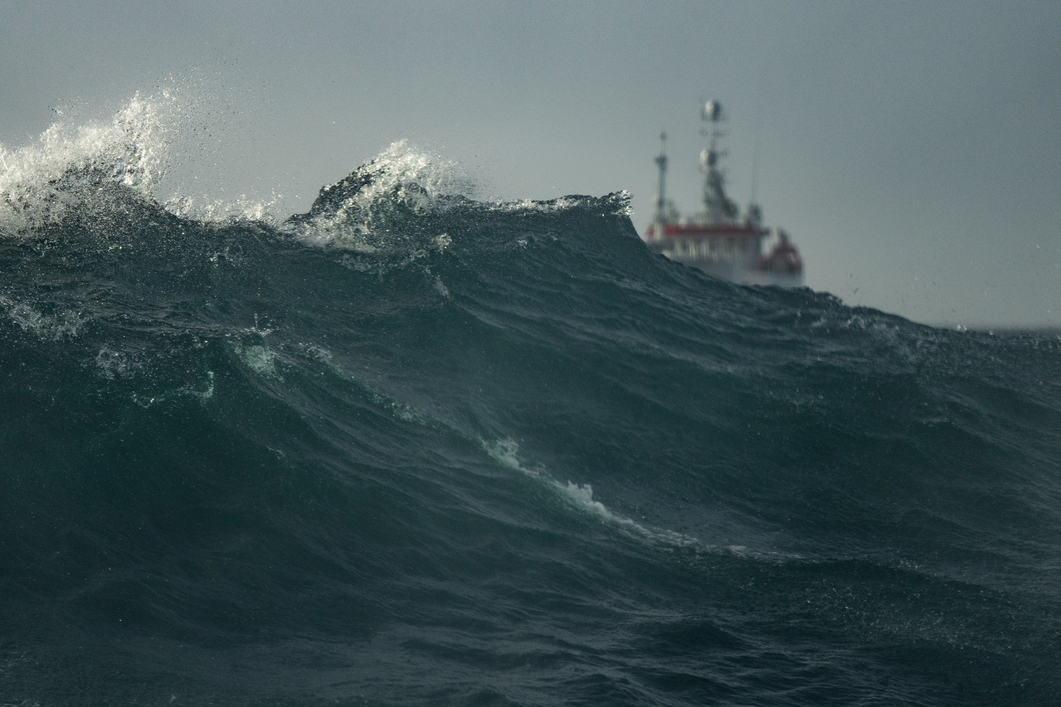
Ports across NSW and Qld are on high alert as Tropical Cyclone Alfred is set to produce damaging winds, large and powerful surf and coastal erosion in the coming days.
Tropical Cyclone Alfred is currently sitting around 600km off Brisbane and is travelling southeast but is expected to make a right turn towards southeast Qld later on Tuesday. Alfred is now expected to make landfall between the Sunshine Coast and the Gold Coast late Thursday into Friday.
The strong winds near Alfreds centre are reaching around 95km/h and with gusts up to 130km/h and are whipping up large waves in the region.
A massive wave 9.59 metres high was observed offshore Brisbane on Monday evening, with other buoys in southeast Qld seeing wave heights rising gradually over the past 48 hours.
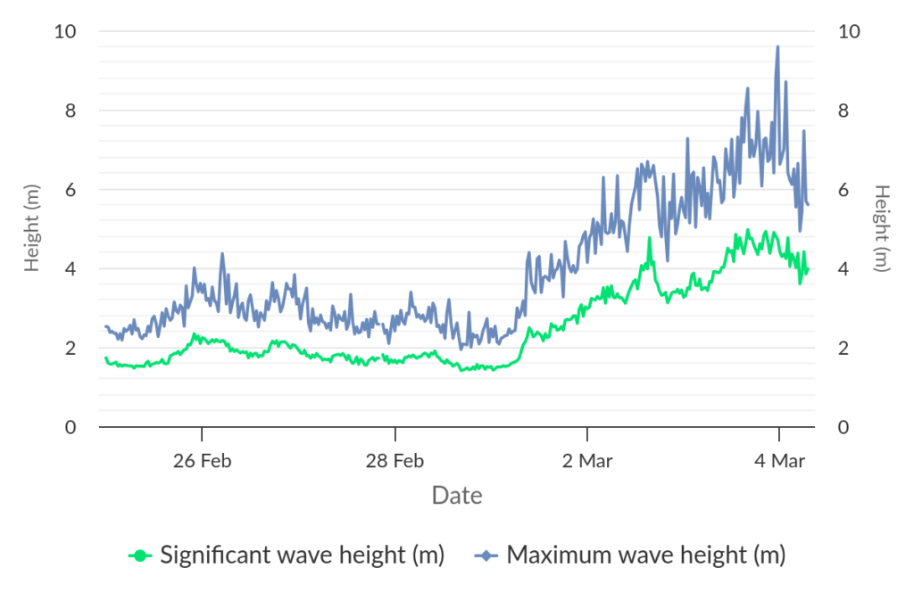
Image: Brisbane offshore wave monitoring showing the significant (green) and maximum wave heights (blue) increasing over the past few days. Source: The State of Queensland 2025
The significant wave height is the average height of the highest one-third of waves in an area, while a maximum wave is the highest individual wave.
These waves are expected to increase overnight Tuesday into Wednesday, with significant wave heights reaching 6 to 8 metres across some parts of Southeast Qld and northeast NSW, with waves offshore possibly reaching 9 to 10 metres. The large waves will also extend into central parts of NSW, with Newcastle’s waves reaching around 3 to 4 metres of Wednesday. Maximum wave heights in the region could reach 14 to 16 metres in the coming days.

Image: DTN’s OneFX significant wave height at 10am AEDT on Wednesday, March 5
These waves will combine with abnormally high tides and water levels could exceed the highest tide of the year this evening.
The combination of the high tides and waves will likely cause significant coastal erosion over the coming days between Sandy Cape and Yamba.
Looking ahead, waves should reduce on Friday after the cyclone crosses however significant wave heights of 3 to 4 metres could continue into the weekend for northeast NSW and southeast Qld.
Damaging wind gusts will also develop between Tewantin and Coffs Harbour coasts on Wednesday as the cyclone approaches. The strength of these winds will depend on the cyclones category as it nears and crosses. At this stage Alfred will either be a category one or two cyclone when it crosses with gusts reaching 120 to 160 km/h possible near the point of landfall.
The image below shows one model’s wind gust forecast for Thursday afternoon, with the purple and navy-blue shades showing damaging wind gusts impacting the coast as Alfred nears.
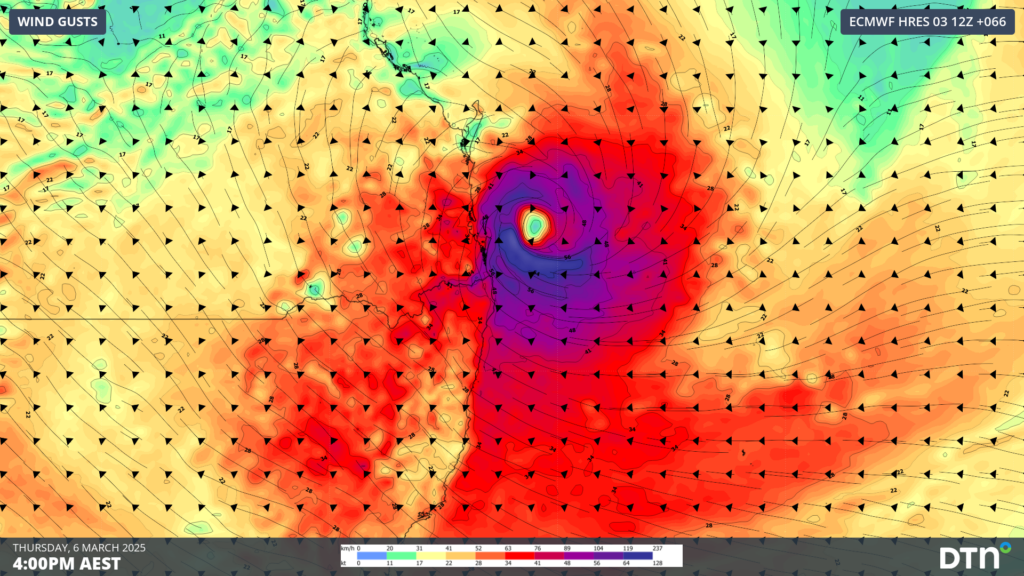
Image: Instantaneous wind gusts at 4pm AEST on Thursday, March 6, according to ECMWF
The damaging winds should ease Friday into Saturday as the system moves inland and weakens below cyclone strength. Heavy rainfall will also impact port operations in the coming days, particularly those near and to the south of the cyclone with onshore winds bringing an influx of moisture to the region.
The conditions over the coming days will challenge port operations across southeast Qld and northeast NSW as Alfred etches towards the region and our meteorologists are providing daily personalised briefings to our clients.
DTN APAC offers a comprehensive suite of services, refined through years of collaboration with the marine, ports and offshore industries, to optimise the safety and efficiency of your operations.
We work with you to understand your intrinsic operational challenges and customise high-precision forecasting, metocean and aviation services to your exact location and operational scope.
When working offshore, our solutions can underpin planning and safe execution for offshore oil and gas enterprises and wind farms. Our data can support your exploration, development, rig moving, shuttle tanker operations, and production and decommissioning phases. Whether your crews are on-site, being transported to shore, or diving to perform maintenance, we deliver tailored weather risk briefings to ensure you choose the optimal time to proceed.
DTN APAC’s trusted nowcasting and forecasting system, OpticastTM, allows you to rapidly respond to changing conditions offshore, en route and in port. We take your port topography and berth orientation into account, ensuring site-specific forecasts. For offshore oil & gas, wind farms, ports and logistics, we have your weather situational awareness covered, no matter where you are. We deliver real-time severe weather and lightning alerts to your team via your integrated dashboard: Portzone, and our Weatherguard app.
DTN APAC’s Total Lightning Network (TLN) ensures you avoid hours of unnecessary downtime by providing the most accurate technology in lightning detection and alerting. Safeguard your teams and assets with lighting and Dangerous Thunderstorm Alerts (DTAs), customised to your existing parameters and delivered in real-time across all devices in your network. You gain full spatial awareness of developing severe weather systems, allowing you to plan ahead and, where needed, execute your shutdown and evacuation procedures.
With extreme conditions slowing production and affecting infrastructure, safety and transport, trust us to deliver Australia’s most precise weather data and tailored insight, giving you decisive confidence when it’s most needed.
To find out more about large range of products and services contact us at sales.apac@dtn.com
Thumbnail image: Istock/piola666


