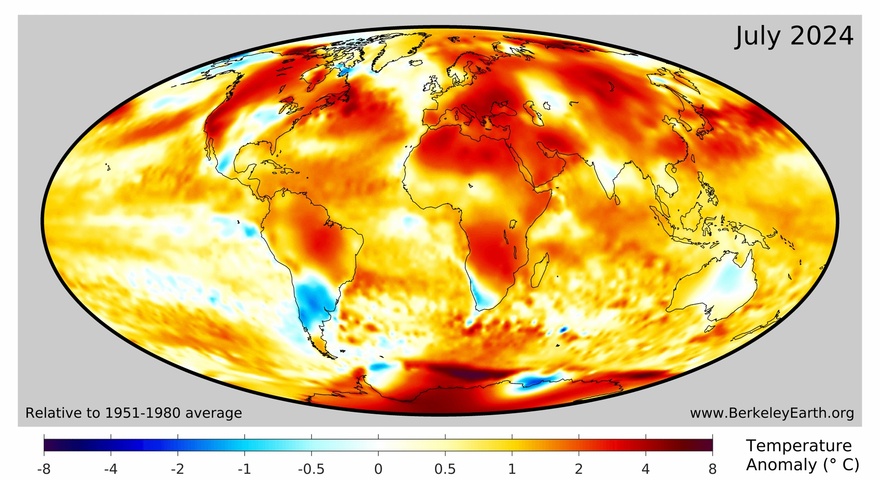
New data from Berkeley Earth reveals that Earth’s hottest July on record makes it virtually certain that 2024 will become our planet’s hottest year in recorded history.
According to the data from Berkeley Earth, the global average temperature in July 2024 was 1.58°C above the 1850 to 1900 average. This is on par with the temperature anomaly from July 2023, which makes the last two Julys our planet’s equal warmest calendar months on record.
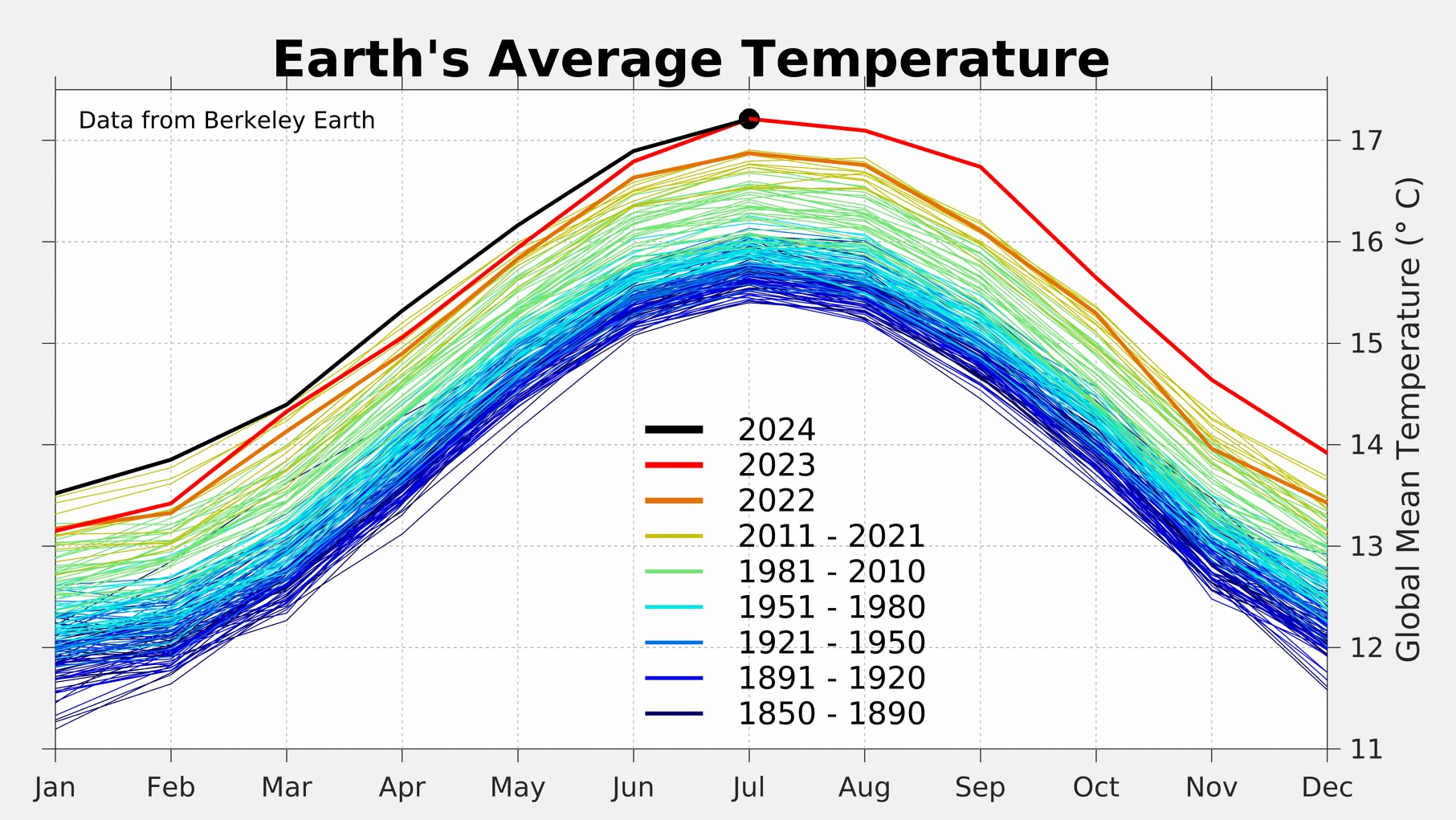
Image: Global mean monthly temperatures from 1850 to 2024. Earth’s seasonal temperature cycle peaks during the Northern Hemisphere summer because of the higher land-to-ocean ratio in the Northern Hemisphere compared to the Southern Hemisphere. Source: Berkeley Earth
July 2024 also capped off an exceptionally warm 12-month period for Earth’s climate. The global mean temperature during the 12 months ending in July 2024 was 1.67°C above the 1850 to 1900 average.
According to statistical modelling from Berkeley Earth, 2024 now has a 96% likelihood of beating 2023 as Earth’s warmest year on record. While a La Niña-like pattern in the Pacific Ocean is likely to make the last few months of 2024 comparatively cooler than the final months of 2023 on a global scale, this cooling influence shouldn’t be strong enough to prevent 2024 from setting a new annual record for Earth’s global mean temperature.
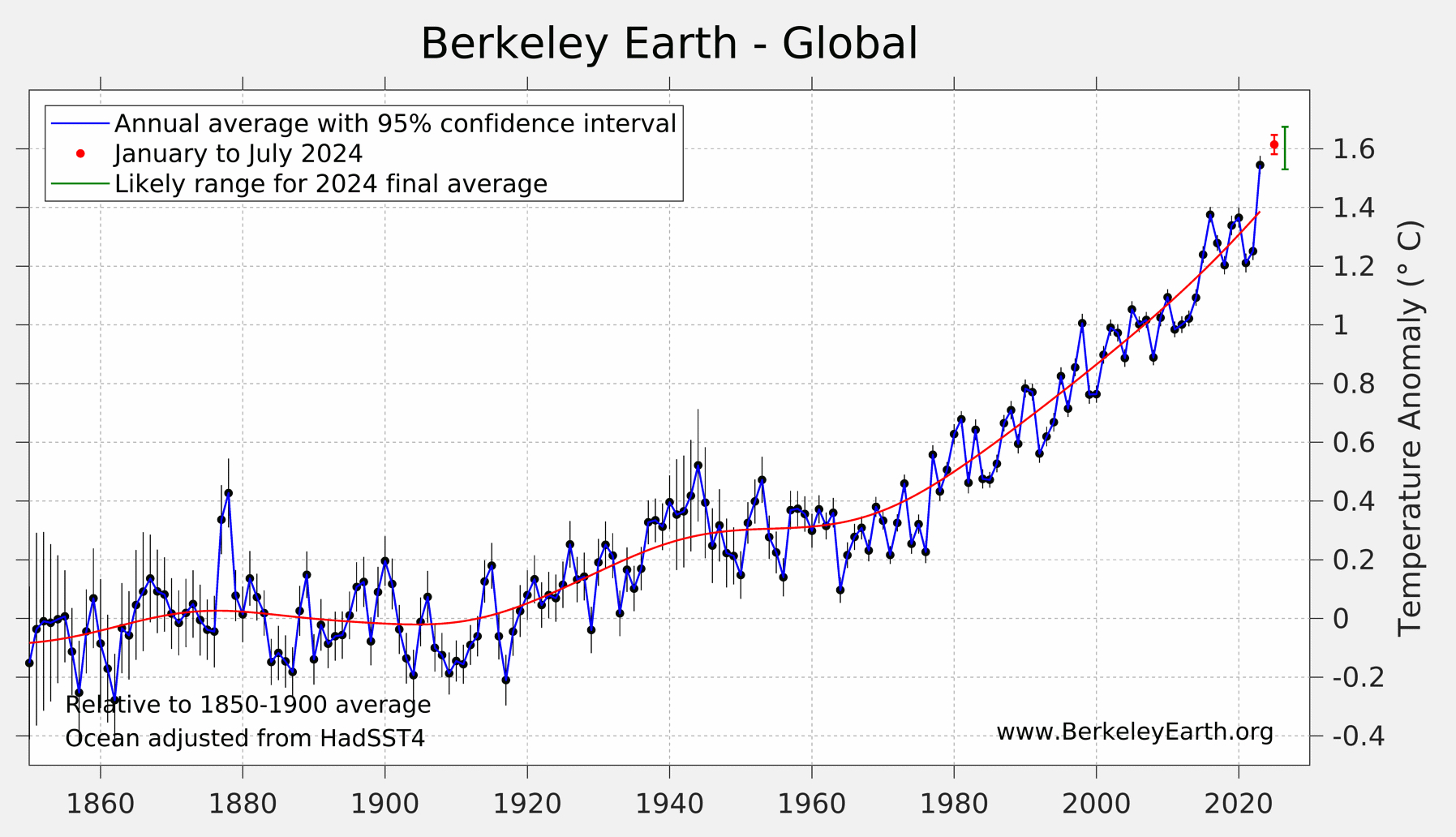
Image: Annual global average temperature anomalies relative to the 1850 to 1900 climate. In the top right-hand corner of this graph, the red dot shows the year-to-date average for 2024, while the green bar next to it represents the likely range that the final 2024 annual average will land in. Source: Berkeley Earth
This year’s record-breaking warmth is due to a mix of natural and man-made factors, including:
- The background warming influence of climate change
- Warming from El Niño early in the year
- Enhanced warming in the North Atlantic Ocean, which Berkeley Earth say is “due to new marine shipping regulations that abruptly reduced maritime sulfur aerosol pollution by ~85%”
While climate change has had the biggest influence on the long-term global temperature trend during the industrial era, natural variability (e.g. the influence from El Niño) has a stronger impact on temperature fluctuations from year to year.
The shifting climate is bringing increased complexity and greater risks to businesses worldwide. We are here for you, delivering trusted weather solutions to optimize your operations and profitability.
DTN APAC is a diverse team, with global forecasting, product development and analytics expertise. Couple this with extensive industry experience spanning Aviation to Energy, and we are primed to assist you in strengthening your response to weather
impact.
We work hard to identify your operational pressures and tailor our services and products to meet your needs. Concise communication, giving you full situational awareness exactly when you need it, is our focus. We want to reduce weather risk in your operations, every day. To find out more visit our contact page or email us at apac.sales@dtn.com.


