
A wet spring could be on the cards for large parts of Australia, with several models suggesting a negative Indian Ocean Dipole could develop in the Indian Ocean.
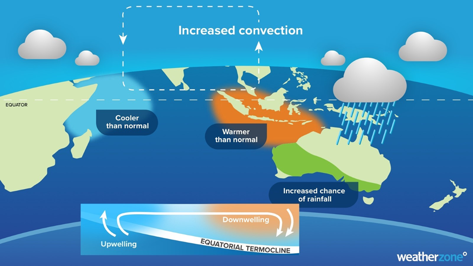
A negative Indian Ocean Dipole (IOD) refers to a pattern of sea surface temperatures in the tropical Indian Ocean that causes more moisture-laden air to flow towards Australia.
These negative IOD events, which occur on average once every five years, typically enhance northwest cloudbands over Australia and produce above-average rain over large areas of the country’s south and southeast during winter and spring.
The Bureau of Meteorology declared yesterday that there is an increased chance of a negative IOD in spring. This declaration comes after four out of five climate models are now predicting a negative IOD event to emerge in spring, before returning to neutral during the beginning of summer. Interestingly, the Bureaus’ model is erring on the positive side during spring.
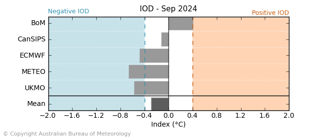
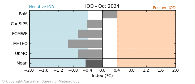
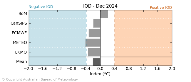
Images: Global climate model IOD forecasts (top to bottom) for September, October and December.
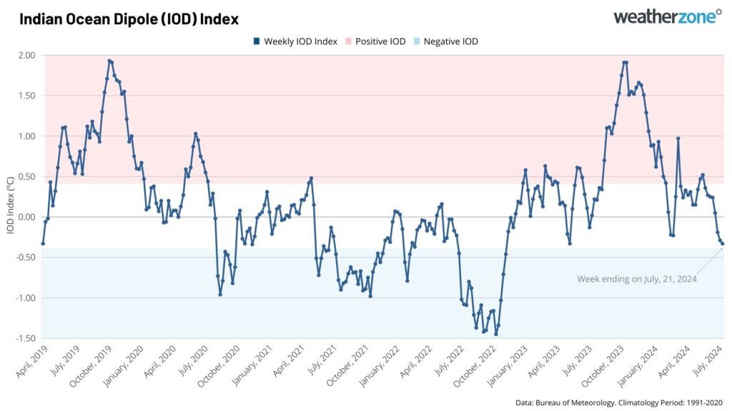
Phases of the IOD have impacted Australia’s weather during the last three years, with negative events occurring during 2021 and 2022, while in 2023 we saw a strong positive IOD. As such, 2021-2023 is tied with 1996-1998 as the longest stretch in which the IOD was observed to be in a non-neutral state.
If we were to see a negative IOD develop in 2024, this would become the longest stretch we have seen the IOD in a non-neutral state since reliable records of the IOD began in 1960. As you can see in the graph below the IOD is currently in a neutral state, which means it’s not impacting Australia’s weather this winter.
For a negative IOD to be declared, the Bureau requires sea surface temperatures in the Indian Ocean to have remained near or exceeded the negative IOD threshold of -0.4°C (blue in image above) for the last eight weeks.
For a negative IOD to develop, the ocean and atmosphere need to be ‘coupled’, which means that the difference in sea surface temperatures in the western (cooler) and eastern (warmer) Indian Ocean is sustained by an atmospheric circulation. This requires winds to be more westerly and northerly than usual over northern Australia, allowing warmer than normal water to be dragged towards Australia’s northwest coast.
There are signs that the atmosphere is mirroring the oceans, like the winds being more northerly than normal near Indonesia, but there is a long way to go yet.
Impacts of a negative IOD
A negative IOD can have a significant impact on Australia’s weather during winter and spring.
The pattern of sea surface temperatures during negative IOD events typically cause more atmospheric moisture to flow over Australia from the northwest.
This moisture can fuel vast northwest cloudbands, which can cause:
- Widespread rain
- Increased thunderstorm activity
- Flooding
- An increase in snow, particularly in winter and early spring
- Reduced solar output
The map below shows how negative IOD events typically affect Australia’s winter-spring rainfall.
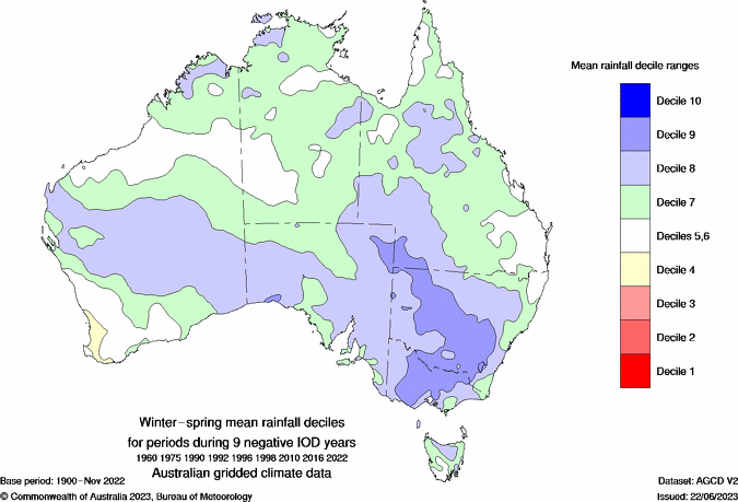
Image: This map shows the impact a negative IOD would typically have on Australia’s rainfall during winter and spring. Source: Bureau of Meteorology
The increased cloud cover and associated rain caused by negative IOD episodes can cause:
- Below average daytime temperatures across large areas of the country.
- A reduced risk of early season extreme heat
- Warmer than average nights, with cloud trapping the heat in overnight.
- Increased humidity across large parts of the country.
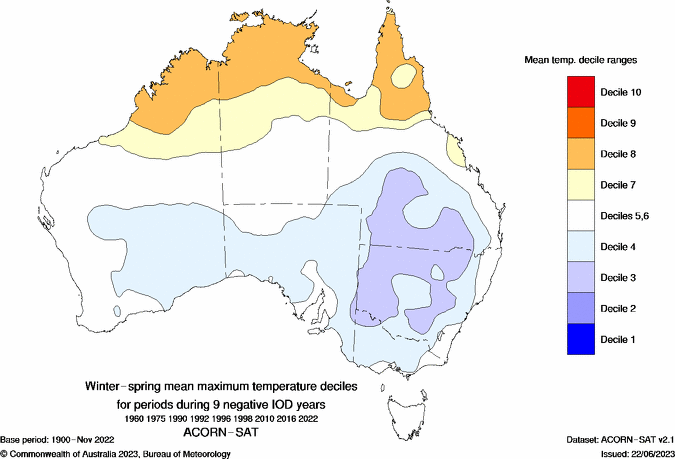
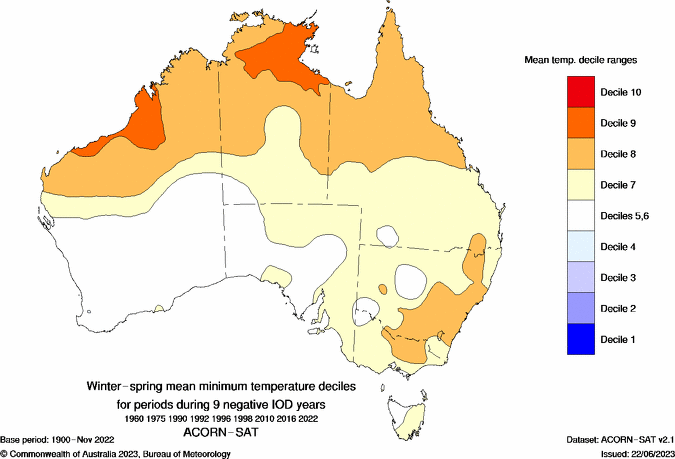
Images: These maps show the impact a negative IOD would typically have on Australia’s maximum (top) and minimum (bottom) temperatures during winter and spring. Source: Bureau of Meteorology
We will continue to watch the Indian Ocean closely in the coming months and update you. To find out more on how this could impact your business in the coming months, please visit our contact page or email us at apac.sales@dtn.com.


