
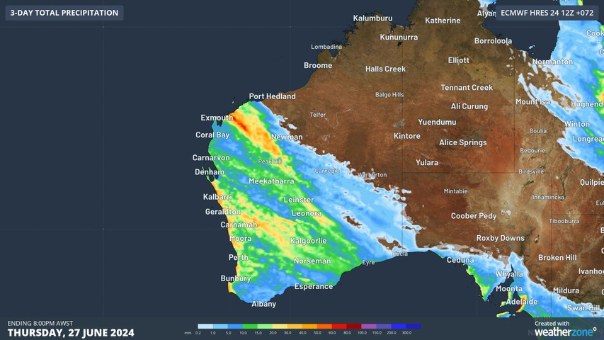
A large swathe of Western Australia is in for a decent drop of rain in coming days, with showers potentially penetrating further north and east than you’d typically see with a winter cold front.
The image at the top of this story shows the predicted rainfall accumulations to 8 pm Thursday, after which the atmosphere will slowly begin to dry out across most of the shaded areas.
And the image below shows why the coming rain is so desperately needed. It’s the rainfall graph for Perth over the last 12 months, and it’s representative of the situation right across southwestern WA.
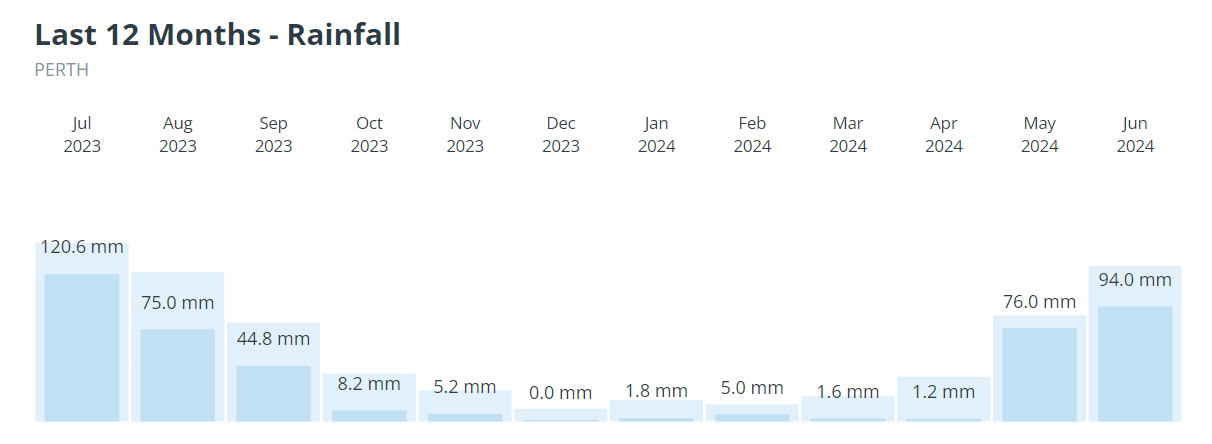
- As you can see, Perth has had below-average rainfall for each of the last 12 months.
- So even though winter started with good falls and the city has recorded 97 mm in June 2024 to date, it still needs another 33.3 mm to reach the monthly average.
- The good news is that totals in that vicinity are possible, with 10 to 20 mm expected on both Wednesday and Thursday as the low crosses the coastline and moves inland.
The system will arrive with gusty northerly winds during Tuesday night and Wednesday morning ahead of the first cold front and trough crossing mid-morning on Wednesday. The majority of the rain will fall with the front and there is the chance of thunderstorms.
During Thursday and Friday morning, the core of the cold air, and the low pressure centre will start to cross the region and develop into a cut-off low.
Cut-off lows are low pressure systems which are cut-off from the band of westerly winds which circulate the globe south of Australia. As the cut-off low ushers in the coldest air, scattered thunderstorms could occur across the southwest, while small hail is likely and there’s even the chance of some brief cold-season tornados.
Bitterly cold temperatures made worse by the wind chill can also be expected, and there’s the chance of light snow on the Stirling Range, which rises to an elevation of 1099m not far north of Albany. Friday morning is the most likely time for a brief snow flurry.
Are you safeguarding your utilities assets and personnel from the threat of increasingly volatile weather?
DTN APAC, a DTN company, offers precise weather intelligence and alerting to protect your utilities network when severe weather, floods and fires threaten.
Over 80% of Australian transmission and distribution networks already rely on our proven nowcasting and forecasting out to 15 days. You can rest assured yours is protected by market-leading analysis. With this foresight you can gain lead time to prepare for possible outages, reduce risk and protect your people and profits.
You will never be left in the dark when conditions suddenly worsen. We deliver reliable, up-to-the-minute weather forecasts and analytical tools that give you the power to enhance your operational management and response to weather risk. Our Total Lightning Network is a globally proven solution that accurately identifies and alerts you to lightning strikes within your defined thresholds, supporting the safety of your team.
Your customisable interface has GIS mapping, showing multiple weather layers over your utilities network and offering full situational awareness. You can quickly recognise any threat to your assets in real time. 24-hour asset monitoring allows you to track lightning, bushfires and other severe weather systems that approach your service territory.
Advanced and actionable analytics allow you to act decisively and improve your planning and outage response strategy. Keep the power on this season with Storm Impact Analytics;
- Understand potential outage risk
- Learn from past events and provide accurate restoration timelines for customers
- Restore power faster by managing response teams
- Gain powerful decision-making support
Utilities that have installed Storm Impact Analytics have reported a 39% increase in customer satisfaction. To find out more, please contact us at apac.sales@dtn.com.




